South Okanagan Trail Directory – 100+ Hiking & Mountain Biking Trails
Trail conditions change frequently. Always verify access, seasonal closures, and current fire restrictions before heading out. This trail directory is for reference only and does not replace on-the-ground assessment.
Desert canyon rims, vineyard-draped benchlands, alpine wildflower bowls – the South Okanagan packs more trail diversity into a single valley than anywhere else in British Columbia. This directory covers every major hiking and mountain biking trail network between Kelowna and the US border: 100+ routes, organized by region, with difficulty ratings, distances, seasonal windows, and trailhead parking links. Pick a section, find your trail, go ride.
What’s Inside
- About the South Okanagan Trail Network
- Penticton Area Trails
- Naramata & Hidden Canyon
- Summerland Area Trails
- Apex Mountain & Resort Trails
- Okanagan Falls & South
- Kelowna & West Kelowna Trails
- Okanagan Mountain Provincial Park
- Yellow Lake, White Lake & Mahoney Lake Area
- Spion Kop, China Ridge & Other High-Country Trails
- Trail Safety, Flora & Wildlife
- Getting There: Maps & Trailhead Directions
About the South Okanagan Trail Network
The South Okanagan sits in the driest and warmest corner of Canada. Between Kelowna to the north and Osoyoos at the US border, a strip of sagebrush desert, vineyard-covered benchlands, and forested mountains contains one of British Columbia’s richest concentrations of multi-use trails.
Elevation range | 280 m (lake level)-2,312 m (Baldy summit) |
Trail season | March-November (valley); July-September (alpine) |
Climate | Semi-arid, 300+ sunny days/year |
Trail types | Hiking, mountain biking, rock climbing, rail trails |
Key towns | Kelowna, Penticton, Summerland, Oliver, Osoyoos |
The terrain spans everything from flat, paved waterfront paths along Okanagan Lake to technical singletrack that threads through sub-alpine meadows above 2,000 metres. The region’s low annual precipitation means trails dry early in spring and remain rideable well into late October – a significantly longer season than most of BC. That said, higher-elevation routes above treeline (Apex, Baldy, Mount Kobau) typically remain snow-covered until late June.
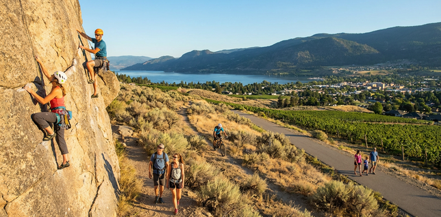
Trail types vary widely. Casual walkers will find family-friendly loops in virtually every community, while dedicated hikers can tackle multi-hour ridge traverses with dramatic exposure above dry canyon walls. Mountain bikers have some of the best cross-country networks in the province, with purpose-built singletrack in areas like Three Blind Mice, Smith Creek, and the Apex summer trail system. Rock climbers flock to the granite walls at Skaha Bluffs Provincial Park, one of the top sport climbing destinations in western Canada.
Most of the land falls under a patchwork of jurisdictions: BC Parks manages provincial parks and protected areas, the Regional District of Okanagan-Similkameen (RDOS) oversees regional parks and trails around Penticton and Oliver, and the Regional District of Central Okanagan administers parks in the Kelowna area. Individual municipalities maintain their own urban trail systems as well. Understanding who manages a trail matters because each agency has its own rules around dogs, bikes, camping, and fire bans.
Important: Wiltsey Highlands Trail Closure
As of April 2024, trails in the Wiltsey Highlands area have been closed by landowners. Access is no longer permitted. Please do not attempt to enter this area. Respect private property boundaries and check current trail status on Trailforks before your trip.
Penticton Area Trails
Penticton occupies the narrow bench of land between Okanagan Lake and Skaha Lake, and the dry hills that rise on every side of town are laced with trails. The variety of Penticton trails is remarkable – whether you’re looking for a quick after-work hike or a full day of mountain biking, the Penticton area delivers surprisingly diverse terrain within a short drive of downtown.
Ellis Creek Reservoir & Dam
Type: Hiking / Trail Running | Difficulty: Easy to Moderate | Distance: ~6 km loop | Season: April-November
The Ellis Creek reservoir sits in a broad valley south of downtown Penticton. A well-maintained trail loops around the Ellis Creek dam and follows the creek corridor through open grassland dotted with Ponderosa pine. It’s a popular spot for dog walkers and joggers, with gentle gradients and wide sightlines. The area can be very hot in midsummer, so early morning or evening outings are advisable.
Campbell Mountain
Type: Hiking / Mountain Biking | Difficulty: Moderate | Elevation: ~400 m gain | Season: March-November
Campbell Mountain rises east of Penticton and offers a network of interconnected trails through dry forest and grassland. The summit provides sweeping views of Okanagan Lake, Skaha Lake, and the surrounding benchlands. Several route options exist, from gentle fire road climbs to steeper singletrack. Mountain bikers share many of these trails with hikers, so stay alert at blind corners.
Three Blind Mice
Type: Mountain Biking / Hiking | Difficulty: Moderate to Difficult | Distance: Network, many loop options | Season: April-October
Named for the three rounded summits visible from Naramata Road, Three Blind Mice is Penticton’s most talked-about mountain biking destination – search Three Blind Mice Penticton and you’ll find hundreds of glowing trail reviews. The trail network sprawls across the hillside above the north shore of the city and features purpose-built singletrack ranging from flowy cross-country routes to more technical descents. Hikers also use the area, though the trails were primarily designed with bikes in mind. Parking is available at the base trailhead off Naramata Road.
Manitou Park & Pump Track
Type: Mountain Biking (Pump Track / Skills Park) | Difficulty: Beginner-Friendly | Season: Year-round (weather permitting)
Manitou Park in Penticton includes a dedicated bike pump track and skills area, making it an excellent option for families and riders looking to practise technique. The pump track features sculpted berms and rollers that reward smooth, rhythmic riding. It’s free to use and located within easy reach of central Penticton.
City of Penticton Surfaced Trails
Type: Walking / Cycling (Paved) | Difficulty: Easy-Fully Accessible | Distance: ~12 km combined | Season: Year-round
Penticton maintains a network of paved multi-use paths that connect the two lake beaches. The Okanagan Lake waterfront path and the channel parkway trail are suitable for strollers, wheelchairs, and casual cyclists. These paths pass through parks, playgrounds, and public art installations, and connect to the broader KVR (Kettle Valley Railway) rail trail system.
Skaha Bluffs Provincial Park
Type: Rock Climbing / Hiking | Difficulty: Varies widely | Season: March-November
Skaha Bluffs is a BC Provincial Park located on the granite cliffs above the east shore of Skaha Lake. It is one of Canada’s top sport climbing destinations, with hundreds of bolted routes across a wide range of grades. Even non-climbers can enjoy the approach trails, which wind through open pine forest with views down to the lake. The Skaha north parking area provides the main access point. Leashed dogs are allowed on trails, but avoid peak climbing areas during busy weekends.
Bordin & WARD Trails
Type: Hiking / Mountain Biking | Difficulty: Moderate | Season: April-October
The Bordin and WARD trail network sits south of Penticton and is popular with both hikers and mountain bikers. The rolling terrain of dry grassland and scattered pine provides good sightlines and a mix of singletrack and wider doubletrack. It connects to other trail systems in the area, making longer loop rides possible.
Quick Reference – Penticton Area
Trail / Area | Type | Difficulty | Best For |
|---|---|---|---|
Ellis Creek Reservoir | Hike / Run | Easy-Mod | Families, dog walks |
Campbell Mountain | Hike / Bike | Moderate | Summit views |
Three Blind Mice | Bike / Hike | Mod-Hard | XC mountain biking |
Manitou Park Pump Track | Bike | Beginner | Kids, skills practice |
Surfaced Trails | Walk / Cycle | Easy | Accessible, casual |
Skaha Bluffs | Climb / Hike | Varies | Rock climbing |
Bordin & WARD | Hike / Bike | Moderate | Loop rides |
Naramata & Hidden Canyon
The Naramata bench east of Penticton is best known for its wineries, but the steep forested terrain above the vineyard belt hides some of the region’s most dramatic scenery. Creek canyons, waterfalls, and high ridgelines reward those willing to climb.
Hidden Canyon Falls (Naramata Falls)
Type: Hiking | Difficulty: Moderate | Distance: ~5 km return | Elevation: ~200 m gain | Season: May-October
Often referred to simply as Naramata Falls, this trail follows a creek through a narrow, moss-lined canyon to a tiered waterfall. It’s a scenic and somewhat rugged hike with a few creek crossings that may require sure footing. The falls are most impressive in late spring during snowmelt. The trail can be slippery in wet conditions, and proper footwear is recommended. Access is off Naramata’s upper roads – check local maps for current trailhead directions.
Rock Oven Trail
Type: Hiking | Difficulty: Easy | Distance: ~3 km return | Season: March-November
A short interpretive trail that visits a historic stone oven built by early settlers, nestled in a creekside forest near Naramata. The flat terrain and short distance make it suitable for all ages and fitness levels. Interpretive signage provides context about the area’s history. It pairs well with a visit to the nearby wineries for a relaxing half-day outing.
Arawana (Beer Run)
Type: Mountain Biking / Hiking | Difficulty: Moderate | Season: April-October
Arawana is a singletrack trail linking the Naramata bench area with other trail networks. Popular among mountain bikers, it winds through mixed forest on terrain that blends flowing sections with moderate technical features. The humorous local name reflects the Okanagan riding community’s laid-back culture.
Smith Creek Trail System (The Holy Pail)
Type: Mountain Biking / Hiking | Difficulty: Moderate to Difficult | Distance: Multi-trail network | Season: May-October
The Smith Creek trail system is one of the South Okanagan’s most celebrated mountain biking areas. Located above the east side of Penticton, the network includes a variety of hand-built singletrack trails through dense forest and across rocky ridges. “The Holy Pail” is one of the signature trails – a technical descent that has earned a loyal following among experienced riders. Expect steep grades, rock features, and tight switchbacks on the more advanced routes. The area also includes mellower options for intermediate riders.
Little White Mountain
Type: Hiking / Mountain Biking | Difficulty: Difficult | Elevation: ~800 m gain | Season: June-October
Little White Mountain offers a significant climb to a high-elevation summit with panoramic views stretching across the Okanagan Valley. The trail ascends through dry forest into sub-alpine zones with exposed rock and open meadows. It’s a full-day hike or a challenging ride, and the upper sections can hold snow into early summer. Water sources are sparse – carry everything you’ll need.
Quick Reference – Naramata & Hidden Canyon
Trail / Area | Type | Difficulty | Best For |
|---|---|---|---|
Hidden Canyon Falls | Hike | Moderate | Waterfall, canyon scenery |
Rock Oven Trail | Hike | Easy | History, families |
Arawana (Beer Run) | Bike / Hike | Moderate | Singletrack riding |
Smith Creek (Holy Pail) | Bike / Hike | Mod-Hard | Technical MTB |
Little White Mountain | Hike / Bike | Difficult | Summit, big views |
Summerland Area Trails
Summerland sits on a series of benches above the western shore of Okanagan Lake, midway between Penticton and Kelowna. The town’s compact geography means you can walk from the lakeshore to the base of a rugged mountain trail in minutes.
Giant’s Head Mountain Park
Type: Hiking | Difficulty: Moderate | Distance: ~3 km to summit | Elevation: ~275 m gain | Season: Year-round (lower); April-November (summit)
Giant’s Head is Summerland’s most iconic landmark – a volcanic remnant that rises sharply above town. A paved road leads partway up, and hiking trails wind to the summit where a full 360-degree panorama reveals Okanagan Lake, the valley floor, and distant peaks. The climb is steady but manageable for most fitness levels. It’s especially popular at sunrise and sunset. Mountain bikes are not permitted on the upper trails.
Trout Creek Trestle & Stroll
Type: Walking / Cycling (Rail Trail) | Difficulty: Easy | Season: Year-round
The Trout Creek trestle is one of the engineering highlights of the historic Kettle Valley Railway. The towering timber bridge spans the Trout Creek canyon and is now part of the KVR multi-use trail. Walking across the trestle offers vertigo-inducing views of the deep canyon below. The surrounding rail trail sections are flat and well-maintained gravel, suitable for strollers and casual cyclists. A shorter interpretive stroll along Trout Creek itself follows the creek bed through a riparian area near the lakeshore.
Peach Cliff
Type: Hiking | Difficulty: Moderate | Elevation: ~300 m gain | Season: April-November
Peach Cliff offers a scenic viewpoint hike above Summerland and the Okanagan Lake shoreline. The Peach Cliff hike climbs through open terrain with sage and bunchgrass before reaching rocky outcrops that serve as natural lookout points. Views extend across the lake to the eastern hills. It’s a rewarding half-day hike without the commitment of a full summit push.
Summerland Centennial Trail
Type: Hiking / Walking | Difficulty: Easy to Moderate | Season: Year-round
This community trail connects several Summerland neighbourhoods through parkland and semi-rural terrain. It’s a pleasant urban walk with some hill sections and access to local parks. A good option for stretching your legs on a rest day between more ambitious outings.
Quick Reference – Summerland Area
Trail / Area | Type | Difficulty | Best For |
|---|---|---|---|
Giant’s Head Mountain | Hike | Moderate | 360° panorama, sunrise |
Trout Creek Trestle | Walk / Cycle | Easy | Rail trail, families |
Peach Cliff | Hike | Moderate | Lake viewpoint |
Centennial Trail | Walk / Hike | Easy-Mod | Urban walk, rest day |
Apex Mountain & Resort Trails
Apex Mountain Resort sits at roughly 1,700 metres elevation in the highlands west of Penticton. Known primarily as a ski hill in winter – locals simply call it the Apex ski hill – Apex transforms into a mountain biking and hiking hub during the summer months. The high elevation means cooler temperatures and access to sub-alpine and alpine terrain that is unavailable elsewhere in the immediate South Okanagan.
Apex Mountain Summer Trails
Type: Mountain Biking / Hiking | Difficulty: Moderate to Difficult | Elevation: Resort base ~1,700 m; summit ~2,100+ m | Season: Late June-October
When the snow melts, the ski runs and surrounding forest become a trail playground. The resort area has a growing network of marked mountain bike trails, from smooth cross-country routes through wildflower meadows to steeper, more technical descents. Hikers can follow ridgeline paths to viewpoints overlooking the Okanagan Valley and the distant Cascade Range. The drive up from Penticton takes about 30 minutes and gains over 1,000 metres, so bring a layer even in August.
Apex Winter Trails
Type: Cross-Country Skiing / Snowshoeing | Difficulty: Varies | Season: December-March
In winter, the Apex area supports a network of cross-country ski trails maintained by local clubs, in addition to the resort’s alpine skiing and snowboarding. Snowshoers also use several routes through the surrounding forest. Check with the Apex Mountain ski resort and local Nordic clubs for current grooming conditions and trail maps.
West Apex Trail Network
Type: Mountain Biking / Hiking | Difficulty: Moderate | Season: June-October
The West Apex network extends through the forest to the west of the ski resort. These trails tend to be quieter than those immediately around the resort village and offer a more backcountry feel. The forest is a mix of spruce, fir, and pine at elevation, with some wet meadow crossings in early season. Route-finding can be less obvious than on the main resort trails, so carry a map or GPS device.
Apex Bowls & Orange Trail
Type: Hiking | Difficulty: Moderate to Difficult | Season: July-September
Above the ski runs, the open alpine bowls are among the most scenic destinations on Apex Mountain. Wildflower blooms in late July and August carpet the upper slopes. The Orange Trail is a marked route that climbs through these bowls and offers some of the best views in the area. The exposed terrain means weather can change quickly – carry rain gear and check the forecast.
Nickel Plate Lake & Apex Lowlands
Type: Hiking / Fishing | Difficulty: Easy to Moderate | Season: June-October
Nickel Plate Lake is a small alpine lake near the Apex area that once served the historic Nickel Plate Mine. A gentle trail reaches the lake, which is stocked with trout and popular with fly fishers. The lowland trails around the lake pass through meadows and open forest, providing a relaxed complement to the steeper alpine routes higher up. The historic mining legacy of the area adds an interpretive layer to the hike.
Apex Mountain Tip
The summit area of Apex is above 2,100 m. Even on warm valley days, temperatures at the top can be 10–15°C cooler with wind. Carry layers, sun protection, and sufficient water. An Apex Mountain map is available from the resort and on Trailforks – download it before you go, as cell coverage is limited at elevation.
Quick Reference – Apex Mountain & Resort
Trail / Area | Type | Difficulty | Best For |
|---|---|---|---|
Summer Trails | Bike / Hike | Mod-Hard | Alpine riding & views |
Winter Trails | XC Ski / Snowshoe | Varies | Nordic skiing |
West Apex Network | Bike / Hike | Moderate | Backcountry feel |
Bowls & Orange Trail | Hike | Mod-Hard | Wildflowers, alpine |
Nickel Plate Lake | Hike / Fish | Easy-Mod | Lake, fishing, history |
Okanagan Falls & South
South of Penticton the valley narrows and the landscape shifts toward true semi-arid desert – sagebrush, antelope-brush, and exposed rock bluffs. The trails in this area offer a distinct character: long ridge walks above dry canyons, historic routes used by cattle drives and fur traders, and surprisingly remote-feeling terrain despite being close to Highway 97.
McIntyre Bluff
Type: Hiking | Difficulty: Moderate to Difficult | Elevation: ~500 m gain | Season: April-November
McIntyre Bluff is a dramatic cliff face rising above the valley between Okanagan Falls and Oliver. The trail ascends the back side of the bluff through grassland and sparse forest to a high point with outstanding views of Vaseux Lake and the entire southern valley. The site holds cultural significance for the Syilx (Okanagan) Nation. Rattlesnakes are present in this habitat – stay on the trail and watch where you step, especially in warm weather.
McDougall Rim Hiking Trail
Type: Hiking / Mountain Biking | Difficulty: Moderate | Distance: ~12 km one-way | Season: April–November
The McDougall Rim trail follows the rim of the benchland west of Oliver, offering sustained views down to the vineyards and orchards on the valley floor. It can be hiked as a point-to-point with a vehicle shuttle or as an out-and-back. The terrain is exposed with minimal shade, so early starts are advisable in summer. The trail sees moderate use and provides a genuine sense of space and solitude.
Mount Kobau
Type: Hiking | Difficulty: Easy (from road end) to Moderate | Elevation: Summit at 1,874 m | Season: June-October
Mount Kobau (often shortened to Mt Kobau on local maps) sits west of Osoyoos and was once the proposed site of a national observatory. An access road climbs much of the elevation, and the final walk to the summit is relatively gentle. The reward is one of the finest viewpoints in the South Okanagan: a full panorama that stretches from the Cascade Mountains to the Monashees, with the Okanagan and Similkameen valleys laid out below. The summit meadows are known for wildflower displays in July. Mount Kobau is also a popular stargazing destination due to its elevation and clear, dark skies.
Oliver Hike & Bike Path
Type: Walking / Cycling (Paved) | Difficulty: Easy | Season: Year-round
The town of Oliver maintains a paved path network that follows the Okanagan River channel and connects to local parks and the International Hike & Bike Trail extending toward Osoyoos. The flat terrain and smooth surface make it ideal for families, inline skating, and easy cycling. Wineries and farm stands are accessible from the path.
Sage & Sparrow Protected Area
Type: Hiking / Nature Observation | Difficulty: Easy | Season: March-November
This protected area near Oliver preserves one of the last remaining tracts of antelope-brush and sagebrush steppe in Canada – an endangered ecosystem. Short interpretive trails allow visitors to observe the desert landscape and its specialist species, including Brewer’s sparrow and several rare reptiles. The area is managed for ecological conservation; stay on designated paths to protect fragile habitat.
Quick Reference – Okanagan Falls & South
Trail / Area | Type | Difficulty | Best For |
|---|---|---|---|
McIntyre Bluff | Hike | Mod-Hard | Cliff views, Vaseux Lake |
McDougall Rim | Hike / Bike | Moderate | Ridge walk, solitude |
Mount Kobau | Hike | Easy-Mod | Panorama, stargazing |
Oliver Hike & Bike Path | Walk / Cycle | Easy | Families, wineries |
Sage & Sparrow | Hike / Nature | Easy | Desert ecology |
Kelowna & West Kelowna Trails
The Kelowna area sits at the northern end of the South Okanagan corridor and boasts the region’s highest concentration of urban parkland and accessible trail networks. From Knox Mountain Park in Kelowna, the city’s most visited natural area, to the ridge of Mount Boucherie across the lake in West Kelowna, there’s enough terrain to keep hikers and bikers busy for weeks.
Knox Mountain Park
Type: Hiking / Trail Running | Difficulty: Easy to Moderate | Elevation: ~300 m gain to summit | Season: Year-round (lower); March-November (summit)
Knox Mountain Park – Kelowna’s flagship urban park – rises directly from the north shore of Okanagan Lake. A network of trails and a seasonal road wind up the mountainside through Ponderosa pine and grassland to two main viewpoints – Apex Point and the Paul Tomb summit area. The lower trails are heavily used by dog walkers and joggers year-round, while the upper routes provide increasingly dramatic lake views. The park is managed by the City of Kelowna, and mountain bikes are restricted to certain trails.
Bear Creek Provincial Park
Type: Hiking / Camping | Difficulty: Easy to Moderate | Season: Year-round (day use); campground seasonal
Bear Creek Provincial Park occupies a canyon on the west side of Okanagan Lake. Frequently searched as Bear Creek BC, the park ranks among the valley’s best lakeside camping destinations. The park features a popular campground and several trails that follow Bear Creek upstream through a dramatic narrow canyon with seasonal waterfalls (the Bear Creek waterfall is most impressive during spring runoff). Short, well-marked loops through the canyon are suitable for families. The park also provides lakeside beach access. Managed by BC Parks; camping reservations are recommended in summer.
Kalamoir Regional Park
Type: Hiking / Lakeshore Walking | Difficulty: Easy | Season: Year-round
Kalamoir Regional Park in West Kelowna offers a gentle shoreline trail along Okanagan Lake with access to several small beaches. The open landscape of grassland and scattered trees provides wide views across the lake to Kelowna. It’s a peaceful spot for easy walks, bird watching, and lakeside picnics. The park is managed by the Regional District of Central Okanagan.
Rose Valley Regional Park & Lake
Type: Hiking / Swimming | Difficulty: Easy to Moderate | Distance: ~5 km loop around lake | Season: Year-round
Rose Valley Lake sits in the hills above West Kelowna and is a popular local swimming and walking destination. A trail loops around the small lake, and additional paths climb into the surrounding hills for expanded views. The lake is warm enough for swimming by mid-June and remains one of the more family-friendly options in the area. Parking can be limited on hot summer weekends.
Goats Peak Regional Park
Type: Hiking | Difficulty: Moderate to Difficult | Elevation: ~450 m gain | Season: March-November
Goats Peak (also listed as Goats Peak Regional Park in some maps) provides a steep climb above the west side of Okanagan Lake to a rocky summit with one of the best lake panoramas in the region. The trail ascends through dry grassland and rocky outcrops. Expect steep sections and some exposure near the top. Rattlesnakes inhabit the lower slopes in warmer months.
Mount Boucherie
Type: Hiking | Difficulty: Moderate | Elevation: ~250 m gain | Season: Year-round
Mount Boucherie is a volcanic remnant in West Kelowna with multiple trail access points. The short but rewarding climb leads to a summit with views over Okanagan Lake and the surrounding wine country. The Boucherie trails parking lot on the west side is the most popular starting point. Several route variations allow loops of different lengths. The dry grassland habitat is ecologically sensitive – stay on designated trails.
Powers Creek Trail
Type: Hiking / Trail Running | Difficulty: Easy to Moderate | Season: Year-round
The Powers Creek trail follows its namesake waterway through a forested corridor in West Kelowna. It’s a shaded, creek-side walk that provides a cool escape on hot summer days. The relatively flat terrain makes it popular with joggers and families. The trail connects to other West Kelowna routes, allowing longer outings.
Carrot Mountain
Type: Hiking / Mountain Biking | Difficulty: Moderate to Difficult | Season: April-November
Carrot Mountain (sometimes referred to as Carrot Creek area) rises behind West Kelowna and provides a network of trails through dry forest and grassland. The trails climb steadily and offer lake views from higher vantage points. Mountain bikers and hikers share the network. Some sections are steep and rocky, suitable for riders and hikers with moderate experience.
KLO Creek Regional Park & Angel Springs
Type: Hiking / Nature Walk | Difficulty: Easy | Season: Year-round
KLO Creek Regional Park is located in Kelowna’s southeast and provides a creekside walking experience through a riparian corridor. The Angel Springs section features a small natural spring area. These trails are gentle, well-signed, and suitable for all ages. They offer a taste of natural landscape within suburban Kelowna.
Glen Canyon Regional Park
Type: Hiking / Walking | Difficulty: Easy to Moderate | Distance: ~4 km loop | Season: Year-round
Glen Canyon Regional Park is tucked into a narrow canyon in West Kelowna, offering a surprisingly lush and sheltered walking experience. The lower and upper sections of the canyon feature creek crossings, mixed forest, and small rock formations. The trails are well-maintained and suitable for families. It’s a popular year-round destination for dog walkers and casual hikers looking for a short but scenic loop close to town.
Quick Reference – Kelowna & West Kelowna
Trail / Area | Type | Difficulty | Best For |
|---|---|---|---|
Knox Mountain Park | Hike / Run | Easy-Mod | Urban park, lake views |
Bear Creek Provincial Park | Hike / Camp | Easy-Mod | Canyon, waterfall, camping |
Kalamoir Regional Park | Walk | Easy | Lakeshore, bird watching |
Rose Valley Lake | Hike / Swim | Easy-Mod | Swimming, family loop |
Goats Peak | Hike | Mod-Hard | Summit panorama |
Mount Boucherie | Hike | Moderate | Quick summit hike |
Powers Creek | Hike / Run | Easy-Mod | Shaded creek walk |
Carrot Mountain | Hike / Bike | Mod-Hard | Trail riding |
KLO Creek & Angel Springs | Walk | Easy | Nature walk, all ages |
Glen Canyon Regional Park | Hike / Walk | Easy–Mod | Canyon loop, dog walks |
Okanagan Mountain Provincial Park
Okanagan Mountain Provincial Park is a large wilderness area that stretches along the eastern shore of Okanagan Lake between Kelowna and Penticton. The park covers over 10,000 hectares and encompasses rugged terrain ranging from lakeside beaches accessible only by boat to high forested ridges.
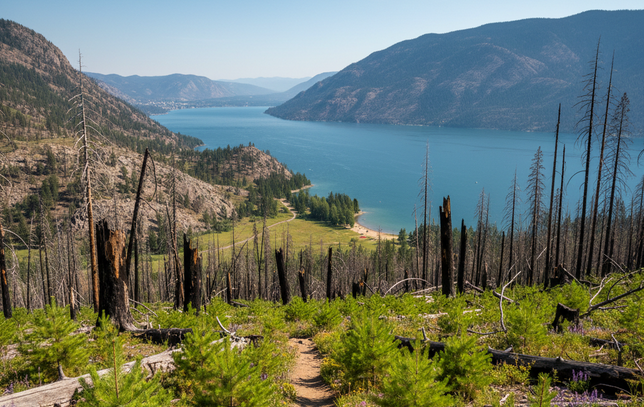
The 2003 Okanagan Mountain Park wildfire was one of BC’s largest fire events and heavily impacted the park’s forest cover. More than two decades later, the recovery is well underway – young pine and Douglas fir are establishing throughout the burn zone, and the open terrain now provides unique views that didn’t exist before the fire. Hiking through the regenerating landscape is a fascinating study in forest ecology.
Main trail access points include the Lakeshore Road trailhead on the south side (from Naramata) and the Chute Lake Road access from above. Trails include multi-day backpacking routes along the lakeshore, with primitive campsites at several bays. Day hikers can tackle shorter out-and-back routes from either end. The park is managed by BC Parks, and backcountry camping requires awareness of fire bans and bear safety practices. There is no vehicle access to the interior of the park.
Planning Tip
Okanagan Mountain Provincial Park is a true backcountry experience. There are no services, no potable water, and limited cell coverage. Inform someone of your itinerary and expected return time before heading in. Check BC Parks (bcparks.ca) for current advisories and fire bans.
Yellow Lake, White Lake & Mahoney Lake Area
Between Penticton and the Similkameen Valley, the highlands hold a series of small lakes surrounded by grassland, pine forest, and open ridges. These areas attract hikers, naturalists, and anglers looking for quiet destinations away from the busier valley-bottom trails.
Yellow Lake Trail
Type: Hiking | Difficulty: Easy | Distance: ~3 km loop | Season: May-October
Yellow Lake sits in a shallow basin along Highway 3A between Penticton and Keremeos. A gentle loop trail circles the lake through grassland and open forest. The area is known for bird watching – the marsh and meadow habitats support a variety of species. The lake itself is a pleasant rest stop when driving over the pass, and the trail is suitable for all ages and fitness levels.
White Lake Lookoff Trail
Type: Hiking | Difficulty: Moderate | Season: May-October
The White Lake area south of Okanagan Falls is a dry, open grassland basin known for its exceptional night skies (the Dominion Radio Astrophysical Observatory is located here). The White Lake lookout trail (also called the lookoff trail) climbs to a viewpoint above the lake basin, providing sweeping views of the surrounding hills. The terrain is exposed and can be very hot in summer, so carry water and sun protection.
Mahoney Lake Ecological Reserve
Type: Nature Observation | Difficulty: Easy | Season: April-October
Mahoney Lake is a small meromictic lake (a lake with layers of water that don’t intermix) and is one of the most scientifically unusual bodies of water in BC. The lake’s deep purple colour comes from a dense layer of bacteria. A short path reaches a viewpoint above the lake. Swimming is not permitted, and visitors should stay on designated paths to protect this sensitive ecological reserve.
Quick Reference – Yellow Lake, White Lake & Mahoney Lake
Trail / Area | Type | Difficulty | Best For |
|---|---|---|---|
Yellow Lake Trail | Hike | Easy | Bird watching, families |
White Lake Lookoff | Hike | Moderate | Dark skies, viewpoint |
Mahoney Lake Reserve | Nature | Easy | Unique ecology |
Spion Kop, China Ridge & Other High-Country Trails
Beyond the main valley corridors, the South Okanagan’s high country offers some of the most rewarding and least crowded hiking in the region. These routes typically involve more driving on forest service roads and higher elevation gains, but the payoff is wide-open ridges, alpine lakes, and a sense of remoteness. For those willing to extend their road trip further north, destinations like Frisby Ridge near Revelstoke offer world-class alpine ridge walking and are worth the drive.
Spion Kop
Type: Hiking | Difficulty: Moderate to Difficult | Elevation: Summit at ~1,525 m | Season: April-November
Spion Kop is a prominent summit near Summerland that offers a steep but well-travelled trail to a dramatic viewpoint above the Okanagan. The name references the Boer War battle, a naming convention common in early BC. The trail climbs through grassland and dry forest, with increasing exposure near the summit. Spion Kop summit provides expansive views in every direction and is a popular sunrise hike.
China Ridge Trails
Type: Mountain Biking / Hiking | Difficulty: Moderate | Season: June-October
China Ridge sits in the highlands between Penticton and the Similkameen. The trail network traverses a high ridgeline through open meadows and scattered timber, with long views across the South Okanagan backcountry. Mountain bikers particularly enjoy the flowing ridge riding. Access is via forest service roads – a high-clearance vehicle may be needed depending on road conditions. This is a quieter destination that rewards those willing to drive a bit further.
Green Mountain
Type: Hiking | Difficulty: Moderate | Season: June-October
Green Mountain is located in the hills above Penticton and provides a moderately challenging hike through mixed forest to a summit viewpoint. The trail is less heavily trafficked than some of the more popular nearby peaks, making it a good option for those seeking a quieter outing.
Baldy Mountain
Type: Hiking / Skiing (winter) | Difficulty: Difficult | Elevation: Summit at ~2,312 m | Season: July-September (hiking); December–March (skiing)
Baldy Mountain (also known as Mount Baldy) is a significant peak east of Oliver. A true high-altitude destination, Baldy Mountain, BC’s quieter alternative to the big resorts, is home to a small community ski area in winter and offers challenging alpine hiking in summer. The summit hike climbs above treeline into exposed terrain with big views. The access road is long and can be rough. This is a destination for experienced hikers who are comfortable with sustained elevation gain and variable alpine weather.
Pincushion Mountain
Type: Hiking | Difficulty: Moderate | Elevation: ~300 m gain | Season: March-November
Pincushion Mountain near Peachland provides a well-used hiking trail to a summit with outstanding Okanagan Lake views. The trail climbs steadily through dry forest and grassland. It’s a solid half-day hike that rewards with views without requiring the full-day commitment of higher peaks. The Pincushion hike is popular and well-marked – the Pincushion Mountain hiking trail sees steady use from spring through fall.
Rattlesnake Lake
Type: Hiking / Fishing | Difficulty: Moderate | Season: May-October
Rattlesnake Lake (despite the name, encounters are uncommon around the lake) is a backcountry fishing and hiking destination accessed via forest service roads. Loop trails around and beyond the lake pass through quiet forest and meadow terrain. The lake supports trout fishing. The area sees relatively light use compared to roadside destinations, so expect a more solitary experience.
Sheeprock Mountain
Type: Hiking | Difficulty: Moderate to Difficult | Season: June-October
Sheeprock Mountain offers a backcountry hiking experience on the less-visited trails south of the main Penticton area. The mountain is named for the bighorn sheep that historically used the area. Trails climb through open terrain to a high point with valley views. Access is via forest service roads, and the route is less formally maintained than urban park trails.
Mount Brent
Type: Hiking | Difficulty: Moderate | Season: May-October
Mount Brent is located near Summerland and provides a less-frequented summit hike with views across the surrounding uplands. The trail passes through mixed forest and open ground. It’s a good option when the more popular local peaks feel too crowded.
Fur Brigade Trail
Type: Hiking (Historic Route) | Difficulty: Moderate | Season: May-October
The Fur Brigade Trail traces a historic trade route used by fur traders and Indigenous peoples through the Okanagan highlands. Sections of the trail can be followed between Summerland and the Nicola Valley, though not all sections are well-marked. It’s a fascinating historical walk for those interested in the region’s pre-settlement heritage. Research your route carefully and carry a GPS device.
Quick Reference – High-Country Trails
Trail / Area | Type | Difficulty | Best For |
|---|---|---|---|
Spion Kop | Hike | Mod-Hard | Sunrise summit |
China Ridge | Bike / Hike | Moderate | Ridge riding |
Green Mountain | Hike | Moderate | Quieter summit |
Baldy Mountain | Hike / Ski | Difficult | Alpine, experienced |
Pincushion Mountain | Hike | Moderate | Lake views |
Rattlesnake Lake | Hike / Fish | Moderate | Backcountry fishing |
Sheeprock Mountain | Hike | Mod-Hard | Remote, backcountry |
Mount Brent | Hike | Moderate | Quiet summit |
Fur Brigade Trail | Hike | Moderate | History, heritage |
Trail Safety, Flora & Wildlife
The South Okanagan’s unique ecosystems – from Canada’s only pocket desert to sub-alpine meadows – cre ate a rich but sometimes challenging environment for trail users. A few things to know before heading out.
Wildlife Encounters
Black bears are common throughout the forested areas, especially in late summer and fall when they’re feeding on berries. Make noise on the trail, carry bear spray, and store food properly. Cougars are present but rarely seen. In the low-elevation grasslands and rocky slopes, Northern Pacific rattlesnakes are a real consideration from spring through fall. They are not aggressive and will generally avoid you, but watch where you place your hands and feet on rocky terrain, especially when it’s warm. Give any snake you encounter a wide berth.
Stinging Nettle & Poisonous Plants
Stinging nettle grows along many creekside trails and in moist, shaded areas throughout the region. Contact with the plant causes an immediate burning, itchy rash (nettle plant rash) that typically subsides within a few hours but can be quite uncomfortable. Wearing long pants and being aware of trailside vegetation is the simplest prevention. If stung, washing the area with soap and water and applying a cold compress can help relieve the irritation. Poison ivy is less common in the Okanagan than in other parts of BC but can be found in some riparian areas – learn to identify its three-leaf cluster.
Heat, Sun & Water
Summer temperatures in the valley bottom regularly exceed 35°C, and many trails are fully exposed with no shade. Heat exhaustion is a real risk for unprepared hikers. Start early, carry more water than you think you’ll need (a minimum of 2 litres per person for a half-day hike), wear a hat and sunscreen, and know the signs of heat-related illness. There are very few reliable water sources along most trails – assume you need to carry all your water.
Fire Season
Wildfire is a natural part of the Okanagan landscape, and fire restrictions or closures can affect trail access, especially from July through September. Check the BC Wildfire Service website (gov.bc.ca) for current fire danger ratings and any area closures before your trip. Campfires are frequently prohibited during fire season, and backcountry users should be prepared to cook on a stove.
Trail Etiquette
Many South Okanagan trails are shared by hikers, mountain bikers, trail runners, and horseback riders. Yield to uphill traffic. Bikers should yield to hikers and announce their presence on blind corners. Keep dogs on leash in provincial parks and any area where signage requires it – this protects both wildlife and other trail users. Pack out all garbage, including organic waste like banana peels and orange rinds, which take far longer to decompose in the dry Okanagan climate than you’d expect.
Getting There: Maps & Trailhead Directions
The South Okanagan trail network is spread across a large area, and knowing where to park and how to access trailheads is half the battle. Here are the key logistics.
Maps & Navigation
For the most current trail maps, conditions, and status updates, the following resources are invaluable. Trailforks (trailforks.com/region/okanagan/) provides the most detailed and up-to-date mountain biking and hiking trail maps in the region, with user-reported conditions. AllTrails (alltrails.com) is excellent for hiking routes, reviews, and downloadable GPS tracks. BC Parks (bcparks.ca) provides official maps and advisories for all provincial parks. For a broader overview, an Okanagan Valley British Columbia map is essential for planning – Google Maps (google.com/maps) is useful for locating trailhead parking areas and driving routes.
Key Trailhead Parking Areas
Several trailheads have dedicated parking lots that serve as the primary access points for popular trail systems. Below are the main parking areas with direct Google Maps links for navigation.
Trailhead Parking – Google Maps Links
Trailhead | Area | Google Maps |
|---|---|---|
Skaha Bluffs North Parking | Penticton | |
Ellis Creek Reservoir | Penticton | |
Three Blind Mice Trailhead | Penticton | |
Knox Mountain Park Parking | Kelowna | |
Boucherie Trails Parking Lot | West Kelowna | |
Bear Creek Provincial Park | West Kelowna | |
Rose Valley Lake Parking | West Kelowna | |
Giant’s Head Mountain | Summerland | |
Apex Mountain Resort | Apex | |
McIntyre Bluff Trailhead | OK Falls | |
Mount Kobau Road | Osoyoos |
Getting Around
Penticton serves as the most central base for exploring the South Okanagan trail network. From Penticton, most destinations are within a 30-to-90-minute drive. Kelowna is roughly an hour north and provides access to the northern trail clusters. Oliver and Osoyoos anchor the southern end. Highway 97 runs the length of the valley, and Highway 3A connects Penticton to the Apex and Keremeos areas to the west. Public transit between communities is limited, so a vehicle is essential for trailhead access.
Before You Go
Trail conditions change. Seasonal closures, fire bans, construction, and private land access restrictions can affect any trail at any time. Always verify current conditions through Trailforks, AllTrails, or the relevant park authority before heading out. This trail directory provides general reference information and does not replace on-the-ground assessment.
Recommended Resources
BC Parks — Official provincial park information, closures, and advisories
RDOS — Regional parks and trails
Regional District of Central Okanagan — Kelowna area parks
City of Penticton Parks — Penticton urban trails
Trailforks — Trail maps, conditions, user reports
AllTrails — Hiking reviews and GPS tracks
BC Wildfire Service — Current fire danger and closures