

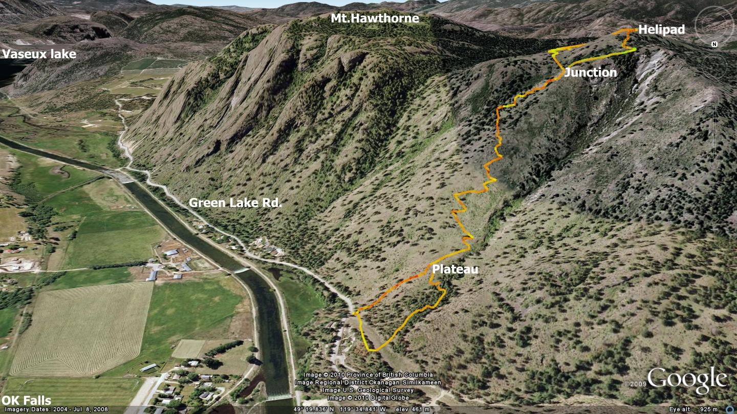
The Overton Trail was developed in order to reestablish access to a hang gliding launch area known as the Helipad, after the original route was severed on the west face of the mountain. Pete Rasmussen appears to have spared no sweat in constructing a quick, albeit challenging route up the area’s east face - and the Roberts family appear to be spending numerous hours maintaining it. This trail’s ultimate destination is a helicopter touch-and-go training pad situated between Mt.McLellan and Mt. Hawthorne. Locals refer to this nearly 360o viewpoint as “the helipad”. Click the image above to enlarge it.
On a warm Halloween day in 2009 I determined that it was time to have a look at what lay beyond a trailhead which I had noticed on many occasions as I drove by on Green Lake Rd. First however, I looked into the land’s ownership on RDOS online, noting that a sliver of the lower terrain was on private property. I revisited the area, crossing the road to knock on the door of the nearest residence. It turned out to be the homeowner of the land in question.
Mr.Overton described a bit of the area’s history since his arrival in 1972, along with details of the trail in question. He had long ago named the trail eponymously, and thus it remains the Overton Trail. Mr.Overton assured me that he has no problem with the hiking community using the trailhead, crossing his section of land in the process. This trail is ‘hike-only’, being far too steep for other activities. In examining the accompanying map, please note that I have rotated it north-south.
At a point 1.4km south of the Green Lake Rd. / Hwy.97 junction, pull off the road to your right and pass through a fence protected by black plastic guards (a hose, cut in two). The small parking area at the trailhead can only support perhaps four vehicles and is located in a position along Green Lake Rd. near a blind corner to the south. As such, extreme caution must be used when entering or exiting the parking area; locals tend to drive the road in a rush...
Do not over-park in the area or we will end up raising the ire of local land owners as well as the Ministry of Highways - and we may lose this parking lot altogether. If the area is full on the day of your visit, then you are not hiking this trail! Many other excellent routes exist in the immediate area; take your pick from at least a half-dozen others nearby. Please do not over-park the area - spoiling site access for others.
Immediately upon crossing the trailhead fence, you will notice left and right hand trail options. These rejoin within the first half-kilometer; the left hand trail is steep, loose and unpleasant to ascend, thus the right hand trail should be your choice. Soon you will see a Terasen gas line, stay on a singletrack trail which runs to the left, just above it. This trail enters a forested area with trails running in every direction imaginable. Climb and bear gently to the left.
Approximately 500m along the trail, it will climb sharply and meet the aforementioned left hand route on a small plateau. From this point forward the trail rises relentlessly, switching back and forth along the mountainside. It continues to do so for the duration of the ascent to the summit.
Along the way you cannot help but be impressed with the amazing views which begin to unfold beneath you. The quaint village of Okanagan Falls, Penticton, Skaha & Okanagan Lakes to the north, McLean & Shuttleworth creeks and their valleys to the east. You will come to welcome these scenic stops, not only for the views, but more importantly, to catch your breath and rest your legs. The most glaring characteristic of this trail is its relentless rate of ascent; 504 vertical meters over a distance of approximately 1.7 kilometers.
At a point 1.5km along, just shy of the summit, you will arrive at a (subtle) ‘Y’ in the trail. The right hand route leads to, among other things, a local high point which hosts a wooden helipad structure. The left hand trail also makes its way to the helipad and areas beyond, and the route is similarly vague, especially during years of heavy spring rains which cause the grass to grow tall and hide the trails.
I will leave the choice of routes to you. Wander the area and drink in the nearly 360 degree views. You may notice faded ribbons in the trees; these demarcate a faint trail heading west. Initial scouting indicates a route that begins to drop toward the backside of the White Lake Observatory.
Between the impressive overall trail consistency, amazing views and potential to link with other trails along the ridgeline, I wholeheartedly suggest that experienced hikers will wish to explore the Overton trail.
Getting there From the Peach in downtown Penticton, head south on Winnipeg St., turn right on Eckhardt Ave., then left on Highway 97. Head south toward Okanagan Falls. Turn right on Green Lake Rd., immediately prior to the OK Falls bridge. Watch for a section of barbed wire with black plastic tubing which covers two strands of the fence on your right. This area appears 1.4k after the Green Lake Rd. turnoff. A small pull off also exists at this point. Respect the area, kick in with some trail maintenance while you are there.
Low: 358m | High: 862m | Length: 3km return | Water: none | Cell Access: Full