

This chapter focuses on a small height of land overlooking the unique White Lake Basin.
Note; when hiking or riding in this area, please turn off your cell-phone. Why? Because the nearby Dominion Radio Astrophysical Observatory is a radio telescope facility, and your cell phone will interfere with the radio frequencies that they may be working with in that area. You will see roadside signs as you approach the area, stating as much.
Realize that even when you are not using your smartphone for voice communication, email, texting or browsing, it will be incessantly attempting to establish communications with cell towers. Please turn it off, or enable Airplane Mode. Our compliance with this simple request allows us and future generations to enjoy recreation in this area.
The White Lake Basin Look-off trail is a short 2.7km (5.4 return) hike / ride with 143m of vertical, which can be enjoyed year-round - depending on snowpack. The route traces old service roads and long-extant trails to a small summit, which offers commanding views over the White Lake Basin, a large plateau, surrounded by mountains on all nearly all sides.
Here in the South Okanagan, it's a unique spectacle, and significantly more breathtaking than the header image atop this chapter suggests.
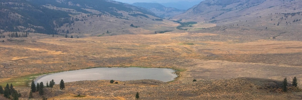
Among other things, the basin features 'White Lake', an often-dry alkaline mudflat that conjures up the most impressive shimmering summer mirages that I’ve witnessed to date. Speaking of which; temps can get awfully hot here, so explore this area as an early morning or late evening hike during the peak-hear months of summer (July / Aug.)
The nearby Dominion Radio Astrophysical Observatory lies 23km. south of downtown Penticton (a 25 minute drive) along Hwy.97. Following the well-signed route, turn right onto White Lake Rd. and proceed 7.3km. to the Dominion Radio Astrophysical Observatory - check it out, or continue 800m further, where you turn right onto Fairview-White Lake Rd. Follow it south for 2.4km, where you come to an obvious parking area and information kiosk on your left. Park there.
Hike north-northwest along the well-defined two-track beside White Lake for a distance 500m. There you'll find an old corral and a junction in the two-track. One route heads straight (the Mahoney-White Lake Loop Trail) while the other heads up / right, along a steepening two-track. Head up.
Ascend for a distance of 1km., where you will come to the first of several ponds, and witness the work of The Nature Trust and BC Parks in fencing off some of the many wetlands in this area. Like many areas of the South Okanagan, this area is part of rangeland, and cattle can be a real problem in damaging ecosystems.
Keep ascending past the pond, 350m beyond it, you will arrive at a second, more significant pond. Here the two-track splits, with one path continuing southeast, past the pond, the other carving hard left, heading up - first east, then due north. Head up.
You'll immediately find yourself edging along another wetland. Please don't enter the wetland-proper for any reason. Doing so may find this trail / area fenced off by BC Parks and / or the Nature Trust, and we'll lose the opportunity to explore and enjoy this amazing place!
Continue to follow along the extreme edge of the wetland, along a well-delineated path which begins to rise as it exits the wetland and enters the forest. From here on, the trails vary between single and dual-track, but the gist of the short remaining route is the you reach the first height of land 350m beyond the wetland just described. From there, head left to the actual rock lookoff point
If in doubt about the veracity of this route, please scrutinize and print out this screenshot of the track, displayed isometricly in Google Earth - or download and preview the Google Earth track for this route from SweetSingletrack.ca. The trail is otherwise physically unmarked on the ground.
Enjoy!
Low: 569m | High: 712m | Length:5.4km. return | Water: Not Potable | Cell Access: turn it off