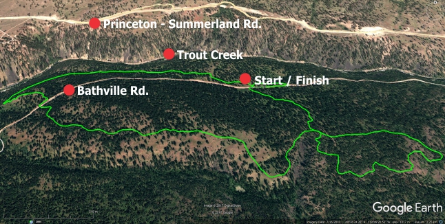
The Morel Loop is the blood, sweat and beer result of Dino G.’s handiwork. He's toured groups of us around the trail loop on numerous summertime mountain bike excursions over the years and we've always enjoyed the ride.
Located approximately 14km. west of the District of Summerland, along Bathville Rd. and sitting at an average elevation of 1055m. / 3461ft., I suspect that it’ll also make a great winter showshoe / nnn bc-style xc loop during decent snow-years as well.
The 6.6km route that you’ll be following here rises and falls through Ponderosa Pine, Interior Douglas Fir and Bunchgrass among other flora, with ever-changing wildflowers throughout the year.
The .GPX and Google Earth files on this site also contain tracks indicating the actual road to the trail-site, as I figured that this would assist in locating and identifying the trailhead.
The area that you are heading into on this one is fairly tame, but as-yet unsigned. I'd suggest that it's a novice level hike, an intermediate level bike ride, and perhaps a beginner to intermediate level equestrian ride.
Due to lack of signage, anyone keen to explore this area must do so with the guidance of a reliable GPS device or smartphone with the Google Earth track from this site.
Speaking of signage: I have a great many retro reflective metal trail-marker squares at hand, care of the Federation of Mountain Clubs of BC.
I'd really like to see this route marked immediately beyond major intersections. If anyone would like to take on this task, and are confidently adept with GPS technology, please contact me.
You'll find yourself in an area which is slightly cooler in the hot summer months, and laden with a bit more snow than the valley in the winter - which are both welcome environments.
Kudos to Dino for promoting and maintaining this great 6.6km loop! Log into www.sweetsingletrack.ca in order to download Google Earth / GPS tracks and explore this fantastic 6.6km. singletrack loop.
Click the header image on this page to enlarge it.
Low: 919m. | High: 1055m. | Length: 6.6km. | Water: None | Cell: None
