Despite what some may consider a politically incorrect moniker, the Kraut trail is an absolutely amazing piece of Singletrack. Though it has yet to catch on with equestrians, the route is popular with hikers and mountain cyclists.
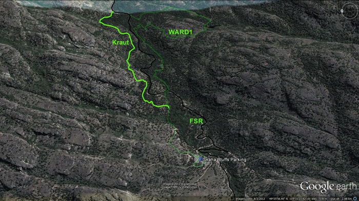
Rising from the northern tip of the upper parking lot at Skaha Bluffs Prov. Park, Kraut begins as the WARD1 trail, but 1km in it splits off to the left and ascends parallel to and on the north side of both Gillies Creek and the currently washed-out forest service road (FSR). Look to the accompanying map and you’ll notice how the WARD1 / Kraut lineage begins, splits, and then roughly parallels one another on opposite sides of Gillies Cr.
Kraut offers rocky outcrops that afford amazing vistas, arcing corners, field-crossing and small, technical ascents galore. It’s a real gut-buster to climb on mountain bike, but a blast to descend! Local riders generally ascend the aforementioned forest service road - taking caution in its eroded state - in order to attain the upper reaches of the most popular local trails.
This watershed hosts the Bordin trail, the Fox, Jamie’s Extension, Kraut, Rock Oven and WARD1 (all presented on this website). A short ride might involve an ascent of the FSR, followed by a descent of Kraut or WARD1.
Despite the fact that this SweetSingletrack entry specifically describes the Kraut trail, it would be a disservice not to mention and present its companion trails in the immediate area, as they complement one another and allow for a wide selection of routes. The small header image atop this page is, as usual, 'click-to-enlarge'. WARD1 has been added to it as a faint line in order to provide overall perspective.
For those of you who prefer topographical maps, this should suffice.
Viewed from the bottom up; ascend WARD1 to the second significant junction on your left, located 1km along the trail. There you will find the Kraut trailhead proper (the first left will be a route into the rock climbing area).
Head up the well-worn Kraut trail for 1.9km, at which point you will enter a level area with a road crossing your trail. 350m shy of this area, near a crest in the trail, you will have noted a quad-trail heading up and to the left. This is the Bordin Trail, a challenging route back toward, and high above Penticton. See the topographical map for clarification.
1.9km in, a flat, open area spreads out before you and hosts the forest service road described previously. To the left it heads up Gillies watershed to Jamie’s Extension and many points beyond. To the right it soon meets a 'Y' in the road; straight ahead leads to the Rock Oven and WARD1 trails (signed), while a right turn and descent leads to the parking lots where you began your adventure.
Note that the singletrack which you are on also crosses the road and heads back into the forest. This short connector ("The Fox") soon rejoins with the two-track heading for the Rock Oven and WARD1 trailheads.
Getting there. Head down South Main St., which soon changes name to Lakeside Rd. Roadside signage directs you to the Skaha Bluffs Prov. Park, a popular rock climbing area. Make your way to the lower or upper parking lots; top if you want to hike the trail, bottom if you want to ride up the service road in order to attain the upper trailheads. If you’re feeling hardcore, try riding up the singletrack from the top parking lot - but don’t say that I didn’t warn you…
Low:512m | High:763m | Length:±6km Rtn. | Water: Not potable | Cell: Full
