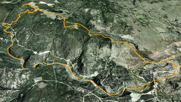
Princeton's China Ridge trail network is located approximately 105km west of the City of Penticton. Don't let the distance discourage you however, as it's well worth the trip for many reasons, notably in this case; singletrack!
My introduction to the area was one of mixed emotions, as I was introduced to the trails by being invited to the Memorial Ride held for the creator of much of the trail network...
Duncan Mackenzie, a Whistler-BlackComb ski patroller, was the lead hand and main trailbuilder of much of what constitutes the China Ridge trail network. Unfortunately, soon after completing the local trails along with a bike skill-park in Princeton, Duncan lost his life in an avalanche while skiing with friends Dec 30th at Caspar Creek, near Pemberton, BC.
During our visit to the area, we met many of his friends and family, as well as numerous Princeton locals - who are really great people!
A convenient location from which to launch your trail exploration is the Princeton & District Multi-Purpose Arena, if only because the aforementioned bike skills park is located there.
From the arena, drive southwest along Old Hedley Rd. for a distance of 1.8km, at which point West China Creek Rd. branches off to the right (north). Follow it up into the rolling hills northwest of town for a distance of approximately 7km. There you will find yourself at the 'trailhead' - which hosts the China Ridge XC ski association's base-lodge.
From there, the two-track turns to singletrack as the Parker trail begins heading first south, then west before snapping back to the north for an earnest ascent to the summit. Along the way you pass the Ruben Jones Hut (cookhouse) as you travel on well-marked trails, reaching the summit and the amazingly well built China Ridge Hut; a small cabin which hosts perhaps 4 persons comfortably at an elevation of 1376m.
But the fun has just begun! Enjoy the cabin, its vistas and generally great ambiance, then head back along the trail for approximately 2,2km where you will see signage indicating the beginning of another trailhead (aka; "The Rail Trail").
The Rail Trail is a fast, flowy, extremely well-built, bermed and banked downhill trail running from the signed turnoff all the way down to the Tulameen riverbank 6.4km / 656 vertical meters below. The Rail Trail features a great number of easy-challenge wooden technical trail features, each lovingly constructed by Duncan. Every 'stunt' is built for thrill and flow, not death-defying action - which is to say, most of you will be able to ride them without fearing loss of life or limb. Kudos to Duncan - this is the kind of trail that deserves to be constructed in every community in BC!
From the waters edge, you head back into Princeton via the beautiful KVR trail, which parallels the rumbling Tulameen river all the way back into Princeton, arriving at the skills park 17km later. This sounds like quite a ride, but in fact its most enjoyable as the riverside KVR is absolutely beautiful, the steep canyon walls are stunning and the numerous KVR bridge crossings and tunnels are intriguing. The community of Princeton has taken care of the KVR surface and allowed for an amazing experience that I encourage everyone reading this to check out by foot or bike; its that good!
The community has created a detailed, fact-filled website that you should peruse here: chinaridgetrails.com
Vert’ Top-Btm: 656m | Length: 42.5km loop | Water: Not Potable | Cell: Spotty
