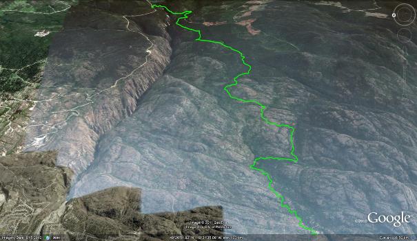
Wright Passage Unlike its nautical namesake, this landlocked route provides access to the upper reaches of numerous trails in the Gillies Cr. watershed. In doing so, it links together a string of singletrack, the lower sections of which are commonly accessed via the valley below. In all, Wright Passage allows riders to enjoy a 'drop' in access of 3200 vertical feet. Click the map above to enlarge it.
I've also been experimenting with some new map layouts, check out this NRC Topo', as perhaps you may prefer this map layout.
The trailhead of Wright Passage is accessed by traveling up Carmi Ave. and turning onto Beaverdell Rd. bearing east for an approximate distance of 17km., measured from the corner of Government and Carmi, at Penticton Hospital.
This is an adventuresome trail, aimed at those not adverse to a touch of hike-a-bike, and skilled enough to pilot their mountain bikes through black to double black diamond terrain. Kudos to JJ for his tireless hours in creating this unique route.
Begin by heading up Carmi Rd., traveling as noted above until you see a yellow and white signboard on the right-hand side of the road titled Ellis Canyon FSR. I'd suggest that you approach this route as a shuttle; arranging for someone to drop you off at the junction of Ellis Canyon FSR and Beaverdell Rd.
I'd strongly suggest that you carry a GPS or smartphone with GPS capability, along with the companion tracks from this website as you make your way along the path. Consider this to be a extremely challenging venture, as injuring oneself in the singletrack sections of this trail will place you in heli-evac territory!
Ride the Ellis Canyon FSR for a distance of 6.7 kilometers, keeping an eye to your left for the (extremely vague) singletrack trail junction. As of Aug.1st, the trailhead is marked with a single yellow length of flagging tape on a small pine tree. Aside from that diminutive marker, one would be unable to discern the trailhead without GPS tracks. Check out this image for an idea of what to look for.
You now face a 1.2km ascent at perhaps 20% grade. Its semi-grueling, and depending on your physical conditioning you may wish to walk brief sections. This two-track gateway to the main singletrack trail is quite overgrown and infrequently used. If you choose to ride it, please do your part and cut back some branches / remove any small deadfall that you encounter. Remember that we are the only 'service crews' that this trail will ever experience...
Once you attain the marshland plateau, the following kilometer or so is relatively flat, and you will soon arrive at an intersection with singletrack heading left and right. Head right, as the left-hand singletrack soon climbs relentlessly until it hits an old FSR which dead-ends on one side (R), and heads up to the 201 on the other (L).
The descending singletrack trail on your right is a masterpiece of 'all mountain' challenge. Its soon morphs into the top of the Jamie's Extension trail, continuing to undulate vigorously until it reaches the old two-track which connects Gillies FSR with the Rock Oven and WARD1 trails. Along the way, the trail presents you with some brutal climbs, dangerous, loose, rocky slopes and a great deal of sweet singletrack!
Don't treat this adventure as you would a 'classic' drop-shuttle, as its much more along the lines of a very aggressive cross-country trail. I recommend a 5" travel or better mountain-bike and that the pilot wear light-weight body armour. I do not recommend that anyone attempt this route on a DH bike!
Once again; if you become injured on this trail, you are in the middle of nowhere. Quads can't get in to save your butt and carrying you out is not an option, as that would require a herculean effort. Injured people are painfully walking out under their own power or taking a trip via helicopter...
Fifteen kilometers along, the route will 'T' with an old, grassy two-track trail which connects Gillies FSR with the Rock Oven and WARD1 trails. Turn right (north) when you meet it (unless you want to ride the aforementioned trails, in which case, refer to those sections of this website) and make your way toward the singletrack trailhead of 'The Fox'. This obvious, but unmarked singletrack trail appears on your right approximately 375m along the two-track as you head north.
The Fox trail makes its way through the forest for approximately a 700m before popping out onto the Gillies FSR. Cross the FSR and reenter the forest west of it; you are now on the (unmarked) Kraut trail.
Kraut begins with a strenuous ascent, but soon morphs into one of the most enjoyable trails in the valley. Ignore the ascending two-track (Bordin trail) on your right, and enjoy Kraut's fast, sweeping turns, challenging rocky step-ups and generally excellent trail surface. Be aware that this is a shared-use hiking / biking trail, and you may meet hikers around any corner.
The Kraut trail will pop you out into the upper Skaha Bluffs parking lot. If you've made it this far unscathed, you deserve a drink! Head into town and enjoy the rest of your day; be aware that the narrow paved road up to the Skaha Bluffs is heavily used and prone to some rather 'interesting' driving techniques...
Low. 500m | High. 1320m | Length. 19km | Water. Not potable | Cell. Lower Sections
