

I am unabashedly fond of the area around Chute Lake for many reasons; though Doreen Reed’s amazing fruit pies, served up at her family lodge may somewhat bias my opinion... Located 31kilometers northeast and 840m in elevation above the city of Penticton, the area’s altitude allows me to escape the oppressive heat of a typical Okanagan summer. It also offers a quick escape into a tranquil country surrounding, complete with a small, out of the way lake. It is these things, together with the many single and dual-track trails that litter the immediate area, which lead me to Chute Lake and its lodge whenever possible.
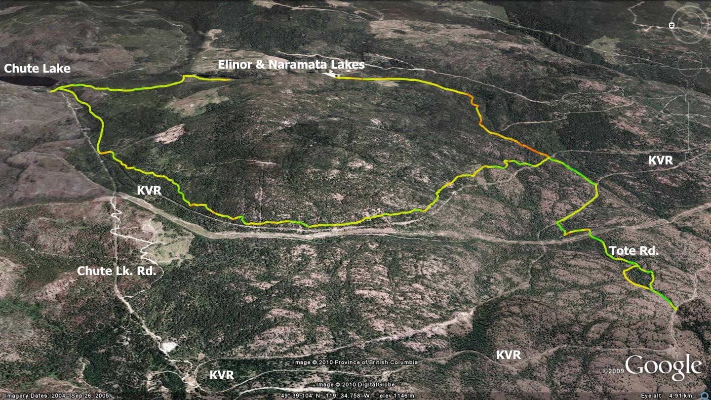
Chute Lake was once an important stop along the way on the KVR railway - it even had a post office. These days it plays host to, among many other things, the start of the ‘Woodwacker’s Loop’. This route circumnavigates an unnamed height of land to the southwest of Chute Lake, running along the Elinor Lake forest service road before connecting with some of the sweetest singletrack in the area; namely the Woodwacker’s Trail. The trail finishes up on a brief section of the historic KVR before leading back to the Chute Lake Lodge.
Due to the long dirt road section at the outset, the overall route might be a bit more than one would wish to hike, it does however make a great mountain bike ride or cross country ski route. While there are several ways to navigate the Woodwacker’s Trail system, I suggest that you start at the Chute Lake Lodge and proceed south along the Elinor Lake FSR road. Three kilometers in, you arrive at Elinor Lake, a small body of water offering camping on the shore and a small waterfall. I have paddled Elinor and found it to be a real gem in the woods, tiny but relaxing. It also offers stocked rainbow trout fishing in spring and summer; guaranteeing a catch.
Naramata Lake lies 400m beyond Elinor to the south. Until recently, it had been one of the water reservoirs for the town of Naramata, thus off limits. The gravel road on which you travel past these lakes is approximately nine kilometers long, measured from the Chute Lake Lodge to where it intersects with the old KVR rail bed. The final few kilometers of the track are slightly steep, loose and potentially dangerous if attempted at speed on a bicycle. You soon pop out on the KVR, where a right hand turn and 375m of travel places you at a day-use picnic area and the Woodwacker’s trailhead. This well maintained area features a picnic area, washrooms and information kiosks - all care of the local Naramata Woodwacker’s Trail Association.
The Woodwacker’s singletrack trail begins at this day use camping area and shadows the KVR for approximately seven kilometers, though you do not see the old rail bed for most of this distance.
Once a footpath for workers who constructed the KVR, the Woodwacker’s trail offers challenging terrain including roots, rocks and small ascents / descents. Watch for trail-junctions as there are two easy-outs along the way, both of which will drop you prematurely onto the KVR. Instead, keep right until you connect with a gravel road. When you reach this gravel road, hang a left and travel it back down to the KVR. At this point, you will be approximately 3km shy of the Chute Lake Lodge.
The end run back to the Lodge is a great wind down which allows you time to consider what flavor of pie and ice cream to order when you arrive! Notice in the map above (tilted on-edge with the north to the left of the page) that I have added an optional south-west exit to this route. This alternative route is known as the Tote Road. It consists of a combination of dual & singletrack trails that allows one to short-cut between sections of the KVR rail bed switch-backs.
Tote Rd. is a load of fun when ridden as a downhill route on mountain bike. It once joined construction camps as a re-supply route and this particular section of the Tote Road is dedicated to original Woodwacker’s; Ted and Jean Smith. A variation on the Woodwacker’s trail ride could include entering the trail from the north and popping out at the day-use area in order to access the Tote Rd. trailhead. One could then coast their way all the way back to Penticton as the KVR pitches downhill all the way back to Penticton.
Getting there from the Peach, downtown Penticton. Head east on Lakeshore Drive W., left on Front St., through the roundabout and up Vancouver Ave. Right on Tupper Ave., left on Middle Bench Rd. N. In short order, this route changes name to Munson Ave. and then McMillan Ave., before finally settling as Naramata Rd. Stay on Naramata Rd. all the way to Naramata, where you will arrive at a three-way intersection consisting of Naramata Rd., Naramata Rd. N., and Robinson Ave. Continue along Naramata Rd. N., turn right onto Chute Lake Rd. The lodge is 10.7km beyond this last intersection.
Low: 1184m | High: 1292m | Length: 18.7km | Water: Not potable | Cell Access: Spotty