

It was a brisk August morning when Peter Matthews and Graham Punnett revealed the West Apex Trail Network to our small group of riders. Ignoring our own usual good advice, all of us showed up in cycling shorts for a ride in the high alpine… Heck, it was “so warm in the valley that morning” (famous last words indeed). Temperatures near tree line hovered just above freezing, the forest was frosted and our wheels reflected in a thin skim of ice upon the puddles.
These factors, along with a heavy coating of dew on everything else, quickly found our cloths soaked and us trying to avoid the wind. The environment and our attire prompted us to cut our exploration short; we only scouted the first loop of what promised to be a two-part ride through a massive area of Crown land. Our late summer foray is described in the chapter below.
The potential for extended adventure in the area is significant. Approximately 90% of the trail is based upon well-established cow paths, featuring excellent flow and consistency. The balance of the route consists of brief sections of hike-a-bike, along with mountain biking in its truest sense. Though cattle are prodigious trailblazers, they tend to fan out upon entering clearings; this inevitably leads to a bit of sleuthing around the fringes of these areas in order to reestablish the continuation of the route.
There appear to be dozens of excellent cow trails in this area, many of which crisscross this trail at numerous points along the journey. If you attempt unaided navigation of this area, there is a strong chance that you will become lost in the process. I therefore emphatically recommend downloading the GPS track for this trail from sweetsingletrack.ca. Alternatively, buddy up with the Penticton Outdoor Club, as they have flagged routes through much of this area with their trademark red and black dotted tape. The Outdoor Club’s trails do not follow the exact path described here, though they do bring one to the same general area as the West Apex Trail Network’s southernmost extent.
The West Apex Trail Network is what I would classify as ‘an adventurous route’, and I recommend that it be attempted only by those willing to take on some rather creative trail finding.
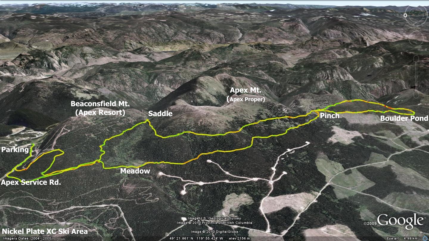
The path begins at the ‘upper’ Apex Resort parking lot, situated at the end of Apex Mt. Rd. The Powerline Rd. runs off the southern end of this parking area, heading west. Follow the Powerline Rd. for a distance of 1.5km. There you will find the Apex Resort service Rd. appearing as a left hand junctioning route. Ascend this road until you reach a sharp left hand corner, 560m along the route. The road continues left; you must go right, heading into the forest.
At this point, you begin to follow what was formerly a dual-track trail, but due to time and forest growth, now looks like a singletrack. Continuing along this trail approximately 725 meters, you will find that the trail splits. Turn left at the split and begin the gentle ascent up the backside of Beaconsfield Mt. (Apex Resort). You gain less than 100 meters of elevation over the next 1.6Km, soon reaching an area known as the ‘Saddle’ - a valley that runs between Beaconsfield Mt. and Apex Secondary (sub-summit of Apex Mt.) Instead of connecting with, and heading along any of the well-established roads in the Saddle, you must turn sharply right (southwest) and begin following a singletrack trail that skirts along the western face of a long mountain ridgeline.
The next 4.4km’s presents one with classic Okanagan singletrack cow trails, generally heading toward the southeast. There exist several hiking and snowmobile routes in the area; more than one of which crosses the West Apex Trail Network. At the 4.4km point, you enter a rough clearing and must cross under a fence. From this point forward; marked as ‘Pinch’ on the accompanying map, I strongly recommend that you use a GPS device and the tracks available at sweetsingletrack.ca
The trail beyond this point is obscure, sometimes disappearing altogether, only to resurface many meters later, heading in a slightly different direction. Those who are GPS-equipped can safely continue south and investigate the 4.5km loop beyond the Pinch point. This section features several interesting elements, including a unique boulder-filled pond and amazing views down a large mountain bowl.
Adventurers without a GPS device should stop and return along the route that they arrived on. Alternately, they may wish to head down a cow-trail leading west then northwest from the Pinch. This will allow them to hook up with the parallel return route of the longer, southern looping trail. A quick examination of the accompanying map or this trail’s Google Earth file at sweetsingletrack.ca will help you make sense of this description.
Your return route is generally well defined; just stick with the main singletrack trail. 4km from the Pinch point along the return leg of the journey, you will enter a large meadow and find that the trail disappears (circa 2009). Hug the left hand side (west) of the meadow as you make your way to its northern edge; the clearing is generally too wet to cross directly. The continuation of the singletrack appears directly across the meadow from its southern entry point.
Three hundred meters into the forest beyond the meadow, the trail takes a sharp right (east) and runs approximately 200 meters where it rejoins the trail upon which you began your journey hours earlier. Turn left at this trail and travel 725m along it, at which point you will meet the Apex Mt. service Rd. Once there, you may wish to drop down and connect with the Powerline Rd. in order to drop again to the Apex Resort top parking lot.
Alternately, those craving more singletrack can ascend the Apex Mt. service Rd. once you meet it. Climb the SR for a distance of 630m, there will see a small roadway on the left heading toward the Grandfather Trail ski run. 120m along this roadway, just prior to gaining the ski run, you will find a singletrack trail crossing the road. This trail represents the lower section of the Good, Bad & Ugly. Head down this singletrack and it will pop you out at the upper Apex Resort parking lot.
The singletrack detour described in the last paragraph is not specifically necessary, as you have the option of simply descending the Apex Mt. service road. The additional singletrack does however add a touch more fun to the finish of a great ride - and we all know that you can never have too much singletrack!
Study the maps here and online before you head out; and please consider my incessant warnings about bringing along a GSP enabled device loaded with files from the companion website. Also, notice how I have tilted the accompanying map, with north to the left of the page. As with so many other maps in this publication, I did this in order to best present the trail upon the land.
Getting there Make your way to Apex Resort from Penticton via a combination of the Green and Apex Mt. roads. Once at the Apex Resort village, follow Apex Mt. Rd. until it dead-ends into the old ‘upper’ parking area.
Low: 1805m | High: 2091m | Length: 22km Return | Water: Not potable | Cell access: Mostly