

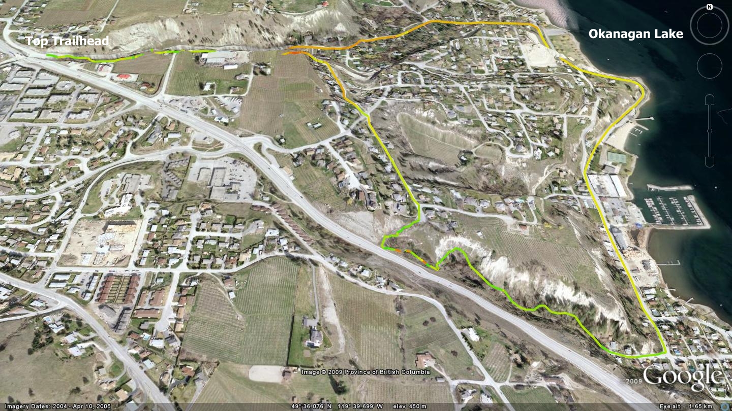
Summerland’s Centennial Trail consists of a pair of singletrack trail systems, connected by sections of paved roadway. These two roughly east-west running singletrack trails follow gullies cut by ancient waterways - Aeneas Creek (Barclays Ravine) to the north and Prairie Gulch to the south. Both trails represent historic transportation routes between Lower Summerland and the orchards above by early settlers. The community of Summerland has pieced together and named this route, allowing tourists and locals alike to enjoy a bucolic 4.5k journey around the area’s first town site.
Travelers may begin exploring the trail system from below and just east of the highway 97 overpass which Peach Orchard Rd. crosses beneath. There you will find a well-signed singletrack trailhead. Little parking exists in the immediate area, so it’s best to enjoy this trail as a hike or bike using a parking area in close proximity - the nearby 7-11 parking lot or the end of Pineo Ct., southwest of the overpass.
While much of the trail is fairly easy to traverse on a mountain bike, beginners may still find brief sections of it challenging, thus the blue or ‘intermediate’ trail rating. Don’t read too much into that however, as the scariest thing about the trail remains the paved sections - where you are at the mercy of motorists and their driving habits.
From the entrance on Peach Orchard Rd., head down the slightly rough singletrack trail which parallels the road for 600 meters. At this point you will see a trail ascending the clay bank to your right, take it. A short climb later you will find yourself popping out onto the northern end of Bristow Rd.
Head south on Bristow Rd., crossing Solly Rd. and proceeding to the south end of Bristow. There you will find a cul-de-sac and a descending roadway on your right, heading down toward the highway. The entire 675 meter length of Bristow Rd. will leave you impressed with the amazing views available to the east.
The aforementioned steep paved section runs nearly down to the highway before abruptly ending, at which point a singletrack trail leads off to the southeast. Follow it and you will find yourself descending creek-side along historic Prairie Gulch Trail. Several well-made bridges crisscross the creek, and you find yourself travelling a moderately steep trail which makes its way toward the end of Butler St. With its seclusion within the deep, nearly vertical walled ravine, the route offers escape from the fact that you are practically in the middle of a community of 11,000 people.
The trail ends at the western extent of Butler St., and here you once again follow paved roads in order to reconnect with any kind of singletrack trail, and thus complete the Summerland Centennial Trail loop. Head east on Butler Rd. until it meets Shaughnessy Ave. 120 meters later. Within one city block Shaughnessy Ave. changes name to Lakeshore Drive South. Follow it north, travelling near the lake through Lower Summerland, all the way to the intersection with Peach Orchard Rd. 1.5 km later. Head up Peach Orchard Rd. until you see Latimer Ave appear on your left. Proceed to the fifth driveway beyond Latimer Ave. on your left. There you will find a widened singletrack trailhead which ascends to the Summerland Centennial trailhead 675m later.
It is somewhat unfortunate that the singletrack portions of this route involve significant stretches of payment. However, documents found online describe Summerland’s future trail aspirations and they include well engineered, long range plans for numerous other interconnecting trail networks.
The frequent pavement excursions make this trail network only slightly less interesting for me personally, but for those wishing to see a bit of the original townsite, while exploring some ‘light’ singletrack, it’s hard to beat.
Also on route is the Summerland Hatchery - the oldest continuously running trout hatchery in BC. The facility was established in 1928, but fish rearing at this location dates back to 1918. This is the only trout hatchery that relies on spring water as all others in the province use groundwater by way of pumps. The facilities staff stock approximately 260 lakes in the south central regions of BC. Visitors are welcome September to June and self guided tours run Monday to Friday 9:00 am to 3:00 pm. An interpretative centre depicting the hatchery program is also available. Tours include viewing live fish in and outdoors, videos and learning where to fish around the area.
Getting There: From the Peach, downtown Penticton, make your way to Summerland via Hwy.97. Turn left at the lights and head south on Rosedale Ave. for 340m to the intersection of Pineo St. Head left onto Pineo St., then up Pineo St. to Pineo Ct. Do not go beneath the underpass. Though the trailhead is located there, parking is non-existent. Pineo Ct. offers a small pullout adjacent to the underpass acting as parking for this route.
High: 467m | Low Point: 467m | Length: 4.5Km | Water: Yes | Cell Access: Full