

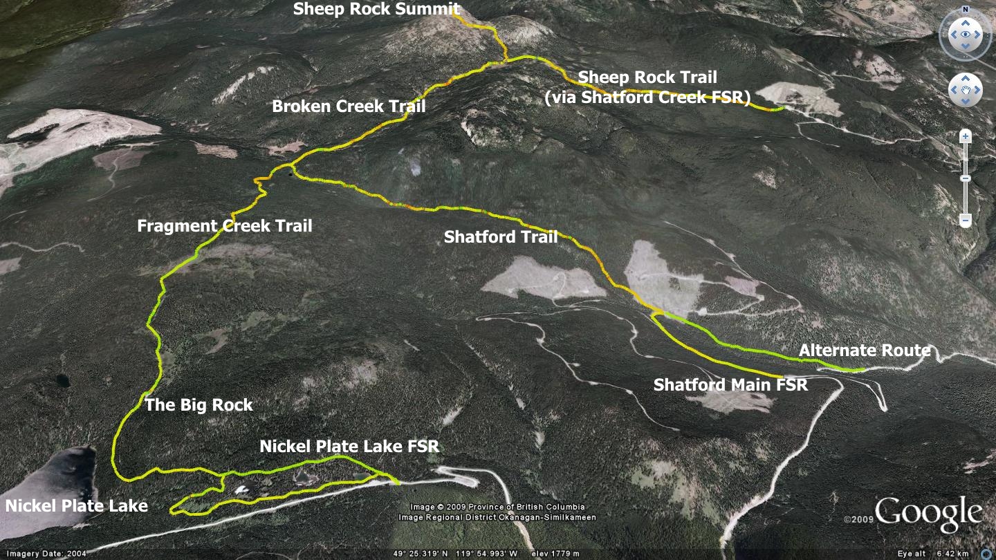
Sheep Rock Mountain offers a bit of everything; flower-filled meadows, creek crossings, rocky & root-filled sections, relentless climbing, outstanding views and one of the longest singletrack descents to be found in the south Okanagan. While numerous routes to the summit of Sheep Rock Mt. exist, I have chosen to highlight only the three most commonly employed:
- Sheep Rock via Nickel-Plate Lake Forest Service road (FSR)
- Sheep Rock via Shatford Main FSR & Shatford Trail (old Joe Harris Cattle trail)
- Sheep Rock via Shatford Creek FSR
I’ve indicated the difficulty level of the trails described here as ‘black-diamond’, due to their length, strenuous climb near the end of the ascent and relative isolation of the route. I would hesitate to introduce a total novice hiker or mountain bike rider to these routes. Consider bringing someone along with experience in the area, or at the very least, a reliable GPS unit as little signage exists on-trail. Tracks for these routes are available at sweetsingletrack.ca
This book will point you in the right direction, but be aware there are numerous dual and singletrack junctions crossing and intersecting with these routes, not all of which are marked or described here due to their sheer number. One aspect of the area worth pointing out is the difference between the similarly titled Shatford Creek FSR and Shatford Main FSR. Both exit right as you ascend Apex Mt. Rd., but each provides access to a different trailhead in this chapter.
Sheep Rock via Nickel-Plate Lake FSR This method of accessing the Sheep Rock summit generally involves mountain-biking, as the route is usually considered too long to hike in. Most folks will navigate this trail using a two-car ‘shuttle’ technique, as the end-of-day descent is outstanding if conducted in this manner. In order to do so, leave the bottom vehicle at either the Shatford Main FSR junction on Apex Mt. Rd. or at the small trailhead marked alternate route on the accompanying map. The alternate route’s trailhead is located two kilometers below the Shatford Main FSR junction on Apex Mt. Rd. It affords a further 2 kilometer descent, but be aware that there is often deadfall across this enticing fast descent.
From either of these Apex Mt. Rd. trailheads, proceed in the top shuttle vehicle to the parking area adjacent to the Hedley-Nickel-Plate Rd. / Nickel-Plate Lake FSR. Park there and begin your trek. Note that the Nickel-Plate Lake FSR is navigable only by high-clearance or 4X4 vehicles.
Locate the Nickel-Plate Lake FSR junction by driving through Apex Village and continuing along Apex Mt. Rd. until you arrive at the Apex Mt. Rd. / Hedley-Nickel-Plate Rd. junction, a distance of approximately 4.7 kilometers, measured from the Shatford Main FSR junction with Apex Mt. Rd. There, Apex Mt. Rd. turns and sharply rises to your left in a nearly switch-back fashion, while the Headley-Nickel-Plate Rd. continues straight ahead and changes to a gravel surface.
Continue approximately two kilometers along the Hedley-Nickel-Plate Rd. to a point at which you will see a rough parking lot to your left with an outhouse partially hidden in the adjacent forest. At this point you will also see a road dropping off to your right, which at the time of writing was marked by vandalized signage reading ‘Hedley-Creek / Nickel Plate FSR’. Park your vehicle in the lot across from it and enter this FSR. You will descend past several small ponds on your left, note the options to navigate them to the north or south (see map). Beginners are advised to stick to the main FSR. Return trips and familiarization will allow you to confidently explore the many small looping roads to the west of ‘The Puddles’, as they are referred to locally.
Stick with the main road for 2.3 kilometers, at which point you will arrive at ‘the big rock’, a waypoint whose moniker you’ll understand when you see it. Here the road splits, with a left hand option wrapping around the north end of the big rock, and dropping to Nickel-Plate Lake, as well as a more or less straight ahead (northbound) route which heads to Sheep Rock and beyond.
Approaching Sheep Rock Mt. via this route allows one to travel from Nickel-Plate to the Sheep Rock summit, double back part way along the trail you ascended upon, and descend to the bottom vehicle via the Shatford trail at day’s end. Shuttling the trail in this manner affords an outstanding vertical drop on a mountain bike. Alternately, you may forego shuttling altogether, choosing to simply ascend Sheep Rock Mt. from either of the two ‘bottom points’ on Apex Mt. road or via the route described above. These options are tough, but doable – it’s how I initially learned to access Sheep Rock & adjacent Brent Mountain on bicycle. (Tnx. to Ron, Earl & Don)
Travel north beyond the Big Rock for a distance of approximately 1.3km , at which point you will see a junctioning two-track trail on your right hand side. Immediately beyond it you will see a small clearing. Take this new trail, cross the clearing and continue into the forest beyond it.
This new direction has you on the Fragment Creek trail - and on your way to the summit of Sheep Rock Mt. Follow the Fragment Creek trail for a distance of 3.3 kilometers, at which point you will notice a trail rising from the valley to join yours on your right. This is the Shatford trail and your eventual route back down to your drop vehicle. Remember this turnoff during your descent. At this point however, you will be continuing onward and upward to Sheep Rock’s summit.
The junction also marks a change in trail name. You are now on the Broken Creek trail, and on your final leg of the journey to the summit. A further 3.5 kilometers of travel will find you at another small intersection which features a trail rising up from the valley on your right. This is the Sheep Rock trail which rises from a logging landing far below. The Sheep Rock Trail entrance is described later in this chapter.
The route to the summit of Sheep Rock Mt. beyond this point is a fairly steep two kilometer trek, and you’ll notice that the trail oftentimes fades in and out as you make for the peak. Trail consistence and evidence greatly depends on cattle, wildlife and recreational use. For the most part however, it is fairly clear and obvious going from here on. Take some time to thoroughly explore the summit and be sure to check out the views from the north-east facing cliffs. There are actually two peaks adjacent to one another and you will be passing between them.
After a bit of rest, food and water, you are in for a jaw-dropping descent on a bike, or long but relaxing hike down. If cycling, keep your speed under control and wits about you as this is a popular hiking destination. The descending Shatford Trail is described below.
Sheep Rock Mt. via Shatford Main FSR & Shatford Trail On your way back down from the summit, you will soon arrive at the previously described Shatford Trail junction which lies 5k from the Sheep Rock summit, heading southwest. Here you have the option of taking a left and dropping to the lower vehicle that you may have elected to leave at the junction of Shatford Main FSR and Apex Mt. Rd. You may also proceed straight at this point, returning you to the Nickel Plate parking area.
Here I describe the Shatford Main FSR / Shatford Trail from the top-down, but only to allow you to understand how it may be used in a car-shuttle procedure. The trail doesn’t necessarily have to be explored in this manner. One could simply park at the Shatford Main FSR junction on Apex Mt. Rd, and in conjunction with the Shatford Trail, attain the summit of Sheep Rock. This method is how I originally learned the area
Prior to the establishment of the Sheep Rock Trail described later in this chapter, hikers frequently used this access route. Nowadays it is considered “the long way up”. While the ascent is gradual, it is also relentless. Mountain bikers favor its long and entertaining descent.
Said descent, running from the three-way Broken Cr. / Fragment Cr. / Shatford Trail intersection, to its meeting with a clear-cut below, is fairly obvious and straightforward. Follow the main trail, there are no major turnoffs - and watch your speed as this is a popular route. Due to the fact that this trail, like so many in this publication, is unmaintained, you really need to keep your wits about you, especially on this tantalizingly long descent.
Upon reaching the clear-cut below, you have several route options. If you left your vehicle at the spot marked ‘Alternate Route’ on the accompanying map, then head for the wide singletrack trail (former two-track width) that you see evident on your left, crossing the clear-cut landing area and dropping southeast into the forest. This route drops down through a fast-paced, 1.6k descent to Apex Mt. Rd. Use caution as there are frequently fallen trees across this path.
If, on the other hand, you left your vehicle at the Shatford FSR / Apex Rd. junction, hang a right and follow the logging road southwest, across the bridge at 90m and to an intersection at 300m. There you will intersect with the Shatford Main FSR. Follow it down to its intersection with Apex Mt. Rd., a distance of perhaps 1km.
Sheep Rock Trail (via Shatford Creek FSR) Those of you not inclined to mountain bike in via Nickel Plate Lake or the Shatford trail will be happy to know that a classic hiking route exists to the summit - thanks to the Penticton Outdoor Club. I have only hiked this route once, several years ago, bereft of my trusty GPS unit. Luckily, my friends John Gullick from the Penticton Outdoor Adventurers and Brad Houston from the Penticton Outdoors Club were kind enough to supply me with both GPS data files and detailed descriptions. The following words flow from Brad Houston and the GPS trail data is care of John Gullick. Thank you gentlemen!
Use the same access road that is used to access the Mount Brent trailhead, namely the Shatford Creek Forest Service road. (Note the specification of Shatford Creek FSR vs. Shatford Main FSR - Ed.) Shatford Creek FSR begins 4.3 km from the point at which you turned off Green Mt. Rd. and began ascending Apex Mt. Rd. at the Apex Aspen Ranch. This route has recently been 'deactivated' by the ministry, but is navigable for those with high-clearance vehicles..
Once on the Shatford Creek FSR, take the left branch of each fork in the road, except the one at 6 km that drops down to the left at a cattle guard; here you want to go straight ahead. At km 6.3 there is an old logging landing on the left, providing a large space for parking.
If it hasn’t been vandalized, there is a trailhead sign put up by Parks BC which reads Brent Mountain - Sheep Rock Trail Head. Parks have installed several widely spaced timbers to form a kind of stairway dropping down off the road. It then becomes a well flagged, well beaten trail once you are into the forest. Ignore an initial animal trail to the left and continue downhill to the right, crossing an excellent bridge built by Parks. Beyond the creek, the trail climbs up one of the few muddy sections to a dry ridge, following it north and heading uphill. The remainder is dry, semi open, with reasonable grades.
The trail should be quite obvious, between the worn down, visible path and the occasional flagging tape on trees, one of which will generally be in sight. Attention must be paid on the way down, that one doesn’t deviate off into the wild, as there are several well beaten animal tracks that cross the trail. About an hour and a quarter into the hike, there is a very large flat topped boulder on the left which makes an excellent stop for a snack and a view south. Following this, the trail passes through fairly open, previously burned land.
Here the path can be obscure, there are many large buried boulders for a couple of hundred meters, but rock cairns and flagging tape helps show the way. This largely open ridge is one of the best areas for a show of purple heather. The steep cliff face of the eastern peak of Sheep Rock looms up ahead to the west, providing a good landmark.
The trail works its way across quite rocky terrain before dropping down to the ponds forming the eastern source of Broken Creek at the base of the cliff. As you drop into heavy trees, note a wide trail coming downhill on your left, joining the one you are on near the bottom of the hollow. This is a cattle trail that is the most boggy, muddy, miserable route for at least half of its length, so do not get lured onto it on your way back. Even though it would be possible to get back to your car on it after a couple of extra kilometers, I guarantee you will not be a happy hiker.
Now wide and well beaten, the trail swings left and follows a series of ponds in a hollow which gradually form a creek. A flat fairly open area appears next. Here one must watch for the trail that takes one up to the top alpine meadows. The most obvious trail continues due south (heading down along Broken Creek) but the one you want leads uphill to the right.
The proper route is flagged. Don’t cross the creek unless you want to head down the old Joe Harris cattle trail (Shatford Trail – Ed) to a switchback on the Apex Road.
With the western branch of Broken Creek below and to your left, you break through to a huge alpine meadow, sitting in the saddle between the eastern and western peaks of Sheep Rock. In flower season this area features lupines, Indian paint brush, purple asters and yellow arnica.
A snow field, near the top of the north east face often persists into August. This top country is wild and wonderful with cliffs, rocky ridges, glacial erratics and 360 degree views. On the north edge of the summit facing Brent Mountain, a 250 meter cliff falls sheer. It is a great place to explore (the top of the cliff, not the face). Just keep oriented so you know where to head back for the trail home as there are no tracks or trails up top.
I like to explore the top of the east summit as well. Although it is treed, there are great views, especially above the cliff that forms the eastern side. There are currently no trails on this summit, so tackle this only if you have justified confidence in your woods craft. There are many open leads in the forest as you head east uphill, allowing you to gain the top of the east cliff without any bush whacking.
Follow the line of least resistance along the top of the cliff, working your way south, you drop down to meet the trail you came up on above Broken Creek. This involves working your way down a few steep sections. Most people just head back off the west peak and ignore the eastern one, a wise choice for those not adept at bushwhacking and finding their way without a trail.
Getting There Start from the Peach, downtown Penticton; drive south on Winnipeg St. until it intersects with Fairview Rd. Stay on Fairview to the major intersection with the Channel Parkway (Hwy 97). Cross the highway into the Penticton Indian Reserve and onto Green Mt. Rd. Follow Green Mt. Rd. to its intersection with Apex Mt. Rd. Follow Apex Mt. Road to Apex village. Shatford Main FSR junctions with Apex Mt. Rd. on your right, 7.9k from the Apex Rd. / Green Mt. Rd. junction.
Low: 1415m | High: 2194m | Length: 21.7km / varies | Water: Not potable | Cell Access: Spotty