Rose Valley Lake hosts one of the first trail networks in the Central Okanagan that I was introduced to back in the early 90's - and remains an underutilized singletrack area by many South Okanagan residents. This is likely because no readily available maps detailed the area's trails. Hopefully this chapter will fix that up!
For Pentictonites, the mostly four-lane highway between Penticton and West Kelowna (nee; Westbank) will get you onsite in perhaps 35 minutes.
The Rose Valley trail network centers more or less around the lake itself and consists of a mix of Crown, RDCO and park land; with 250ha of parkland comprising much of the eastern shore of the Lake.
During de-glaciation, large amounts of water flowed down the valley and around a stagnant piece of ice occupying Okanagan Lake. Rose Valley was formed during this time as a melt water channel. It's steep, aesthetically appealing cliffs are volcanic and the caves on the west side of the lake are thought to be large air bubbles in the lava.
Rose 'lake' is actually a man-made reservoir built in 1949 to hold water diverted from Lamby Creek. This body of water and many surrounding roads and landmarks take their name from a pioneer Kelowna family; surname Rose. It supplied water via flumes to new orchards developed under the Veteran's Land Act for the resettlement of World War II vets.
On July 19, 2009 within hours of the initiation of the Glenrosa fire, a human caused fire started near the earth dam at the south end of the Rose Valley reservoir. Together, these two fires lead to the evacuation of more than 10,000 residents in the Westbank area. The Rose Valley fire was located entirely within Crown land, specifically the Westbank First Nation Community Forest.
In the fall of 2009 WFN installed a series of wattles (a building technique using woven wooden supports packed with clay or mud) near the south end of the reservoir to contain potential erosion that was anticipated after the fire. The reservoir and all of the trails on the west side are within the Rose Valley Community Watershed, providing the main source of drinking water for many local residents.
Please respect the watershed or access could be barred by the managers of the community watershed in the future.
Many of the area's routes were simply game trails cleaned up by determined hikers and bikers, some were old two-track roads used for natural resource extraction. Others, like JabberRockey, City on the Edge of Forever, Swamp Donkey and Cattywampus, were hewn out of the earth by riders looking for new challenges
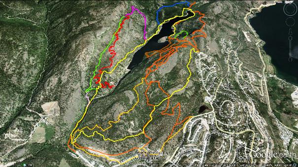
The Rose Valley Loop and JabbaRocky trails are easy to follow to the point that it would be difficult to loose oneself on them. The Rose Valley Ridge line trails are a spider-web of interconnectivity and numerous sub-trails in the area do not show in the accompanying maps. A local school trail-running group has erected white arrow signage that assists in navigating a core loop however.
Study the header image above (click to enlarge), print out the topographical map provided here and load the GPS files available in the GPS and Google Earth sections of this website onto a hand-held device. Between these three navigational aids it should be nigh impossible to get lost while enjoying the Rose Valley trails. When in doubt, head southeast and you are sure to drop into an urban area. The trail network can be accessed via several routes, including:
| The end of West Kelowna Rd.
| A small parking lot on the west side of Westlake Rd.
| Rosealee Lane
| The western terminus of McDougall Rd.
Be aware that the Rosealee Lane entrance offers no parking and vehicles may be towed! Be cool and don't upset the local residents or you may contribute to closure of convenient entrances to the area. Using Westlake Rd. or Westside Rd. will get you into the general area quite readily.
Kudos to Grant for some of the area's history and Mike for the excellent ridgeline tour!
Low:543m | High:909m | Length:Varies | Water:Not potable | Cell:Most areas

