

References to the term Rock Oven apply to areas north and south of Penticton, as well as a slope on Apex Mt. Rd. The original application of the phrase relates to the historic rock ovens used by Kettle Valley Railway workers as they constructed the KVR between Penticton and Okanagan Mt. Park, north of the city. The Rock Oven trail described in this chapter deals with a challenging route that rises out of the Gillies Creek canyon south of Penticton. In order to avoid confusion between the two similarly titled areas, I will henceforth refer to this southern Rock Oven trail as the ‘Rock Oven singletrack’.
The Rock Oven singletrack is hands-down the most technical, yet rideable, trail in the South Okanagan. Notice that I have rated it a double-black diamond for difficulty; I have yet to hike the loop, but have mountain biked it dozens of times, and can attest that it challenges lungs while ascending, and bike handling skills on the descent. Many riders who attempt this route end up walking their bikes up or down numerous sections.
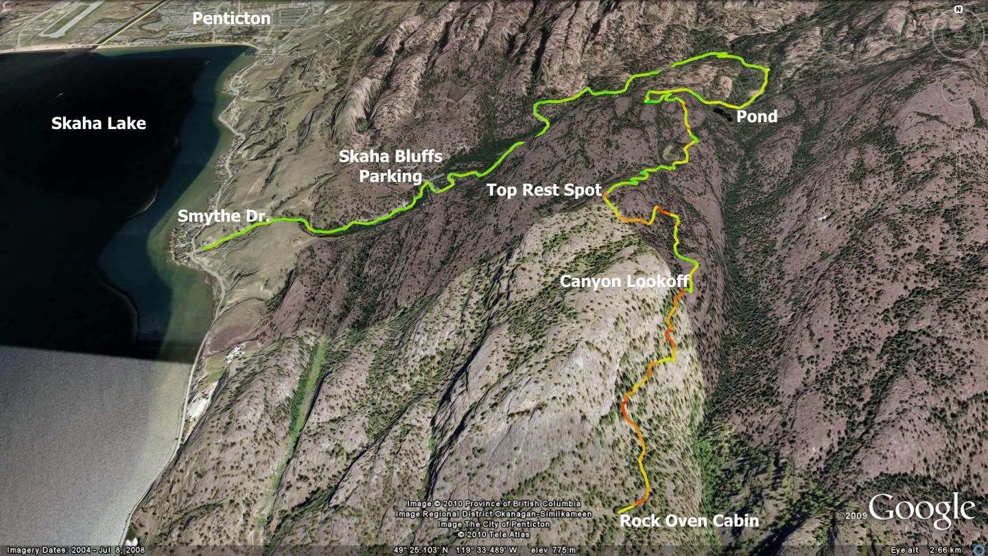
Access to the Rock Oven singletrack trail begins with pavement, turns to dual-track gravel, then overgrown grassland two-track, and finally culminates in an amazing singletrack trail system. The initial paved section runs for a distance of 1.4km, at which point the road splits. You may turn left and enter the Skaha Bluffs parking lot, or turn right and continue your ascent via the gravel two-track Gillies Creek FSR. Gillies FSR climbs gently for a distance of 2.5km before it also splits; left leads to Jamie’s Extension, Bordin Trail and numerous other routes further up Mt.Christie. A right hand turn leads to the Rock Oven singletrack trailhead.
Turn right and continue along what is now a grassy, overgrown two-track roadway. It runs for a distance of one kilometer, at which point it meets a small, unnamed pond. Here the trail splits again, with routes straight ahead or to the right. The straight route is a shortcut of sorts to the Rock Oven singletrack, but one that demands some hike-a-bike. The ‘classic’ route up the Rock oven singletrack trail turns right and passes beyond the north end of the pond.
The route ahead narrows and becomes singletrack width; representing what I consider the actual Rock Oven trailhead. From this point forward, you must summon serious fortitude as the balance of the 2.2km ascent to the summit presents pitch after brutal pitch. The entire ascent is ridable provided you are experiencing an ‘on’ day - or are simply in amazing shape!
Approximately 300m beyond the pond you will notice a singletrack trail peeling off to the right; this is WARD1; a great, albeit short trail which drops back down to the Skaha Bluffs parking area. Continue straight ahead, beyond the WARD1 junction, bearing left and ascending.
Five hundred meters along the Rock Oven singletrack, you will find a guest book. This traditional sign-in provides a great excuse to catch your breath and make your mark. The Rock Oven singletrack route is well formed, obvious and does not require detailed description from here on.
Once you attain this trail’s summit, you arrive at an expansive series of open rock slabs and an area that we creatively call the ‘top rest spot’. Views to the north, west and south are stunning and you will likely wish to stop here for a while in order to absorb the beauty of the place.
Though the Rock Oven singletrack trail continues beyond the top rest spot, it soon enters private property. In this publication I have avoided describing trails that enter private lands without permission from the landowners. The Rock Oven singletrack soon descends through a large section of Nature Trust property, followed by lands under private ownership. As I do not have permission from any of these parties to direct the public across their plots, the balance of the trail does not appear in this description or on the accompanying map.
You can freely travel the Rock Oven singletrack trail for a distance of 1.7km further south, beyond the top rest spot; but legally speaking, no further. There exist two interesting features to explore beyond the top rest spot and the beginning of the private lots. The first of these is a steep canyon that features a sheer drop of nearly 150m to the valley floor below. This canyon lookout lies roughly 830m beyond the aforementioned top rest spot. The next feature worth considering is the actual namesake of this trail; a small hut and accompanying oven created from rock.
The hut marks the border between Crown land and Nature Trust holdings. I take no responsibility for what you do beyond this point. I am however, legally bound to suggest that you stop and double-back upon the trail which you arrived on.
Getting there Beginning at the Peach in Penticton, take Winnipeg St. to Eckhardt and turn left. Take Eckhardt to Martin St. and turn right. Take Main St. to the intersection of Main & Kinney, turn left. Turn Right on Main St. South and drive 5.1km to the Smythe Junction on your left.
Low: 350m | High: 905m | Length: 17.6k Return | Water: Not potable | Cell Access: Spotty