

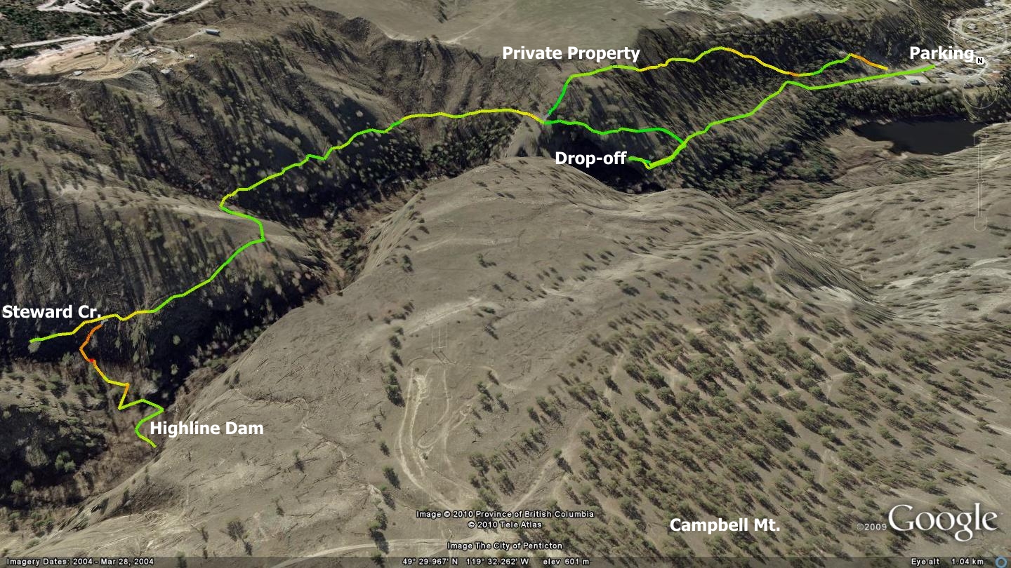
Ridgedale Ave., on the east side of Penticton, terminates in a cul-de-sac bordered by a small graveled area which is ideal for parking while you hike the Ridgedale Ave. singletrack trail.
To the southwest, the blockhouse pump station, and beyond it the first 750m of two-track look innocuous enough - so why the black diamond difficulty rating? The barbed wire fence to your left looks as though it could surround a penitentiary, but crane your neck and you will see that the nasty bit of fence is all that stands between you and a sheer drop to Ellis Creek 40m below.
Soon the trail narrows even more and drops off to, quite literally; doom! Why the department responsible for this land elected to protect you all along the left hand side, only to allow the end of the trail to drop openly off a cliff… I have no idea. Be careful if you go this way in conditions of low visibility. It certainly wouldn’t be a great idea to hike or bike this route in the dark or fog.
In fact, the Ridgedale Trail is not in any sense a bike route; a cyclist perished here in 2008. Once you see the trail you will understand how and why. Note that the image included in this chapter is rotated 90 degrees to provide the best overview of the area.
The Ridgedale singletrack trail is however a great hiking route, situated at the city’s doorstep. After marveling at the aforementioned end of trail drop-off, turn back and walk about 100m up the footpath you came in on. There you will notice a path on your left rising steeply up the mountainside. Ascend it. Note; if you have pets with you, leash them now. If small or rambunctious children are afoot, leash them too!
The penalty for a slip and fall during many stretches of this trail are severe - nasty scrapes at a minimum; death at the most. There are brief sections along this singletrack which are so steep, and the trail situated so near the edge, that I suspect even the most sure-footed canine would perish if it were to lose its footing and tumble down the slope. It’s just that crazily extreme.
If I have not yet managed to frighten you off of investigating this route, carry on for a brief but fantastic hike into the beautiful Penticton Creek Canyon, terminating at an early era dam. Cliffs across the canyon look amazing, and the creek below serenades you most of the trip. I suggest going in the early morning or early evening and enjoy the interplay of light and shadow on canyon walls.
Near the two kilometer mark along the path, you arrive at a major fork in the road. The right hand trail disintegrates into a defunct game trail and meanders up the oftentimes dry Steward Creek; the left hand trail heads down a set of hand dug steps to a ramshackle cabin adjacent to Penticton Creek.
Drop down on the left hand trail and explore what is left of this building, ghosts of the collection and control point for Penticton’s earliest irrigation system, known locally as the Highline Dam. I wasn’t able to find out much about it, not even in the comprehensive listings found within the Okanagan Historical Society’s publications. Old-timers tell me that during the dam’s construction, packhorses carried in all of the concrete mix using the same trail you arrived on - which will seem all the more impressive once you’ve actually experienced this precarious route. In its time, the dam fed an important and elaborate flume distribution system.
This last section of trail is one of the steepest and slipperiest as it plunges into a micro-climate all its own. The area is a little oasis of sorts; the creek serenely rolls by, the forest is full of rich aromas and though one is still so close to town, you are utterly sheltered from all things ‘city’ including cell phone service. Rest, eat and drink up as it’s a steep haul back to town.
Note that the GPS track appears to split into two routes. This is because I did some exploring on the return but soon found that despite nearly countless trails intersecting with the main track, all of them lead to private property. Keep this in mind if tempted to explore these optional routes.
Getting there From the Peach in downtown Penticton, travel Winnipeg St. to Eckhardt Ave. Turn left on Eckhardt and right on Martin St. Martin merges with Main St., follow Main St. to a left hand turn on Duncan Ave. Follow Duncan Ave until it merges with Ridgedale Ave. Turn right and make your way to the nearby cul-de-sac and accompanying parking area.
Low: 490m | High: 580m | Length: 4.4Km | Water: Not potable | Cell access: Parking area +1k in