

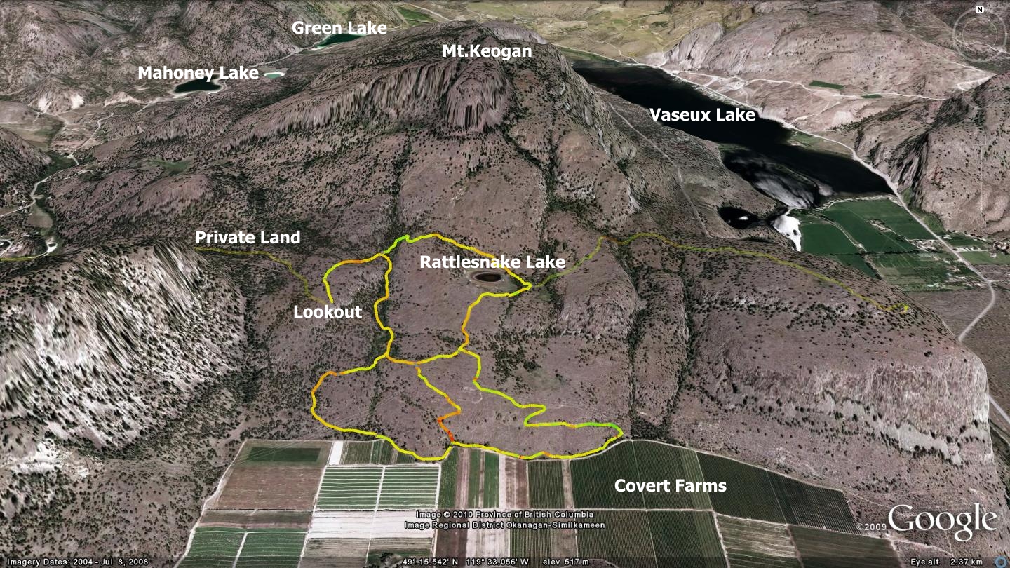
The Rattlesnake Lake Loops reside within the BC Parks Grasslands Protected Area. The bulk of its trails are nestled between the southern slopes of Mt.Keogan and lands owned by Covert Farms, situated just north of the town of Oliver. This moderately challenging trail network is comprised of three trail loops and a lookout. Although you will find many more dual and singletrack trails in the area, the majority of trails to the west and northwest cross onto private property. To the immediate west you will find the Willowbrook Society’s equestrian trails and recreation lands; to the northwest, the steep face of Mt.Keogan - and beyond that, private ranchland.
In the accompanying map, I have depicted the trails heading west - to the Willowbrook lands, as lightly faded lines. Keep in mind that permission or membership is required from the Society in order to use their trail system.
The Willowbrook Society focuses on hiking and equestrian activities; mountain bike riders do not rank highly in their recreational hierarchy, due to the perceived reckless behavior by some mountain bikers. If you are riding your bike and happen upon equestrians while in the Rattlesnake Lake area, please work toward changing the assumption of biker irresponsibility by dismounting your bicycle and walking past horse and rider.
The map also depicts a faded trail heading east; this route leads to MacIntyre Bluff. I include both it and the Willowbrook trail in order to show their relationship with the Rattlesnake Lake Loops. The MacIntyre Bluff trail is detailed elsewhere in this publication.
The Rattlesnake Lake trail system is accessible from numerous directions, but the two most common entries are:
- Via the Willowbrook Society’s Johnson Crescent entrance within Willowbrook - but only if you hold a society membership or have specific permission from the society
- Via Covert Farms, a working organic vegetable farm located just north of Oliver
In this chapter I have described the Rattlesnake Lake trail system as accessed from Covert Farms; if only because there is no controversy when entering this way. Stop your vehicle at the main office and if need be, ask directions to the trailhead. You will be directed to a metal gate at the north end of the working fields. Please do not simply drive through the office area to the fields. Instead, park your vehicle well out of the way of farm machinery. Once through the gate at the north end of the field, please remember to close it firmly behind you. There are many deer in the area who would love to spend time in the gardens and orchards below.
The entire trail network is marked with BC Parks standard brown posts with metal signage affixed. These will be familiar to anyone who has ever hiked a BC Park trail system. This excellent trail signage is thanks to the hard work of the South Okanagan bike Club (Oliver), Mountain Equipment Co-Op and BC Parks.
This trail network is well thought out and marked, but all three of the trail loops require that you ascend a steep toe section of trail before you reach the intermediate plateau which hosts the bulk of the trails.
Enter at the main gate (centre of the trails depicted) and turn right immediately once inside. Continue along the fence line on an excellent singletrack and through one of the largest stands of Sumac I have seen in the Valley. The trail soon meets a dual-track road which heads up to Rattlesnake Lake. This route begins to climb fairly steeply before mellowing and giving way to singletrack again.
You will soon find yourself at what is left of Rattlesnake Lake; usually taking the form of a dried up puddle anytime after June, and well on your way to enjoying the Rattlesnake Lake Loops and lookout.
Oliver’s Rattlesnake Lake trail network is an excellent example of a properly marked trail system and a shining example of what can be accomplished when a grassroots club works in partnership with BC Parks in protected areas. Kudos to Mark Weston (BC Parks) and the Oliver Bike Club for their many hours of hard work, along with their willingness to understand each other’s point of view. I suggest that we make an extra effort to demonstrate our stewardship of the land, in order that we may use this area as a template for future managed trail systems.
The entire trail system is well demarcated, so I will not waste your time with boring descriptions. I suggest that you explore the entire network; and do so on a cool day, as the heat in this area can be stifling mid-summer.
One note to remember; if you choose to make your way up to the 'Lookout', west of the main body of trails, pay close attention during your return descent; the required turnoff is to the right and quite close to the summit. I have personally ridden this area many times, and one two occations have pedaled right on by this junction in my zeal to experience the thrill of gravity!
Getting there Beginning at the Peach in Penticton, drive south on Winnipeg St. to Fairview Rd. Stay on Fairview until it meets the Channel Parkway (aka Hwy.97) Drive Hwy 97 south out of Penticton toward Okanagan Falls, located approximately 16km south. Drive through OK Falls and continue toward Oliver. Turn right on Seacrest Hill Rd., follow it until you see Covert Farm signs.
Low: 437m | High: 556m | Length: 2.5km Average loop | Water: None | Cell Access: Full