


This is an update to the Peach Cliff Trail - the original western access to which has recently been closed to the public.
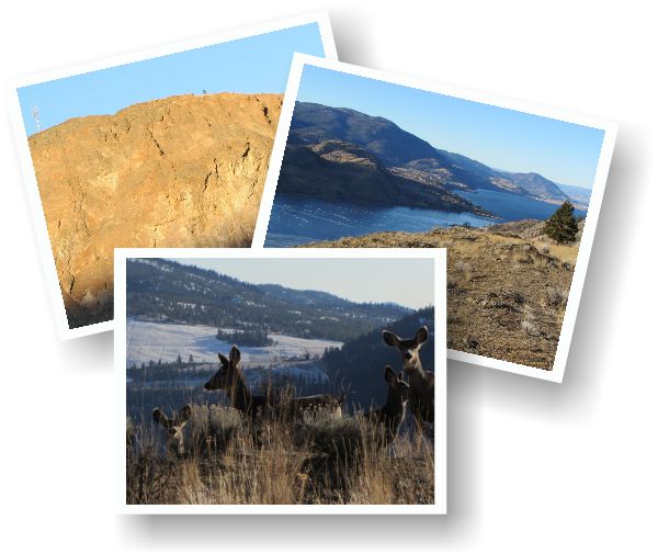
The most prominent visual as one approaches the community of Okanagan Falls is the Peach Cliff - also known as Dusty Mac, for the dormant Dusty Mac Mine operation on its east face. This prominence is part of a larger series of ridges and plateaus colloquially known as "Fire Mountain".
Bordered on the west by Skaha Lake, the north and east by McLean Creek Rd., and on the south by the community of Okanagan Falls, this mass of land is a combination of private property, Nature Trust conservation areas and Crown Land.
Click the image above to view a (much) larger overview map.
The entire area has been extensively mined for silver and gold since the turn of the century by a long succession of companies; Esso Minerals, Cantex-Placer and Noranda among them. These groups sought and mined for gold, silver and copper, but after hundreds of holes drilled and hundreds of thousands of dollars spent, companies found too little of each and the mine has been dormant since 2005.
This chapter highlights three main areas: The Goldfish Pond, near the eastern entrance, Peach Cliff, on the southwest side and the Fire Mountain trails, which is how locals refer to this overall height of land.
The area is littered with dual and singletrack trails running in nearly every direction, and the interconnected looping trails displayed on the maps shown here, along with the accompanying GPS / Google Earth tracks, present perhaps 60% of what actually exists on this height of land.
I'm leaving many of the area's trails off the map on purpose, as much of this zone consists of Nature Trust lands, and the N.T. is more focused on protecting flora and fauna than providing yet another playground for humans.
I strongly suggest that you stick with the tracks presented herein, and please refrain from creating any new trails in the area - thus securing our future access. The explanation for the multitude of singletrack trails becomes evident when one notices the number of deer and California bighorn resident here. The morass of dual-track trails can be traced to the extensive history of mining activity in the area.
Entered from the eastern side via a man-gate (Parking / Entrance on the map) one is immediately faced with a choice of two dual-track roads. The road to your left leads to the Goldfish Pond (a flooded mining excavation, now a flooded pond full of ex-pet goldfish) and the Peach Cliff trail, while the two-track to the right leads to the heart of the Fire Mountain trails.
The Nature Trust of BC purchased much of the area from the Morris Thompson family in the year 2000, using funds from Forest Renewal BC’s private forest biodiversity program. The Thompson property contains a wide variety important wildlife habitats, including ponderosa pine, cliffs and talus slopes, and the globally imperiled Antelope-brush grassland ecosystem.
Some of the many wildlife species that depend on these habitats include California bighorn sheep, Western rattlesnakes, Lewis’s woodpecker and numerous bat species.
The Nature Trust has posted the property with signage stating that hikers are welcome to use the existing trails in the area. Please respect their courtesy by sticking to established routes only and monitoring your person for invasive weeds & seeds.
I’ll not describe every sub-trail that you will cross, nor every intersection - as there are too many to describe without seeing this chapter devolve into descriptive madness. Note that there are no trail-name signs nor directional maps in this entire area. Suffice to say that the main trails are the most beat-in and obvious.
The Goldfish Pond is the easiest feature to locate in this area. It is located approximately 700m from the east entrance, immediately south of a large earthen berm, marked by an old, decrepit core-sample shed; one of many left-overs in this area from historic mining operations.
Another highlight of Fire Mt. is the Peach Cliff trail and lookout. The trailhead for this prominence of land is located 1.3km. northwest of the Goldfish Pond, along an easy, relatively flat trail. Again, nothing is marked, so you will benefit from downloading the GPS (for old-school hand-held GPS devices) or the Google Earth files (for smartphones) available on SweetSingletrack.ca.
The steep route to the summit of Peach Cliff is alive with amazing vistas, and capped off by a spectacular 360 degree vista from the summit. Along the way there are plenty of opportunities to rest your legs, each look-off enroute offers stunning views and photo-ops.
As much as I’m a proponent of hiking with one’s dog, I strongly suggest that you skip Fido's companionship on this one. A vast quantity of prickly pear cactus will torment their paws and the dense population of deer and sheep may lead untrained canines into a chase off the edge of a nearby cliff!
The third highlight of this height of land is what locals generally refer to as the "Fire Mountain trails", which encompasses the balance of the terrain in this area. As noted earlier, I'll not describe (every) possible trail herein, as I don't want to P.O. the Nature Trust, and local secrets are fun.
If you study the maps, and download / utilize the Google Earth tracks as described above, you will be guided through a series of interconnected looping trails, several of which lead to spectacular look offs. Most of this area is rideable on a bike, but some gullies will be a push-bike affair if that is the mode of travel that you choose.
Note that while exploring the mid-mountain zone, I happened upon several signs in one particular gully, requesting 'foot traffic only', which I suspect is a nod to the Nature Trust realizing that the area is popular with mountain bikers, and they've simply designated a few areas as non-mechanized travel.
Please note these areas if you are exploring them on bike, and make a mental note that you may wish to choose to hike there in the future instead.
Enjoy the area, and give a nod to The Nature Trust for being so kind and open-minded as to refrain from erecting "No Mountain Biking" signs in this special-habitat zone.
Your cooperation and respect for this entire area will go a long way toward supporting future access for you, your family and friends.
Low: 458m | High: 635m | Length: Varies | Water: None | Cell Access: Full