

The Nickel Plate Lake & Apex Lowlands chapter tackles a lot of ground, so take some time to digest the following text. I encourage you to visit the companion website at sweetsingletrack.ca in order to download and view the corresponding GPS and Google Earth 3D overview files.
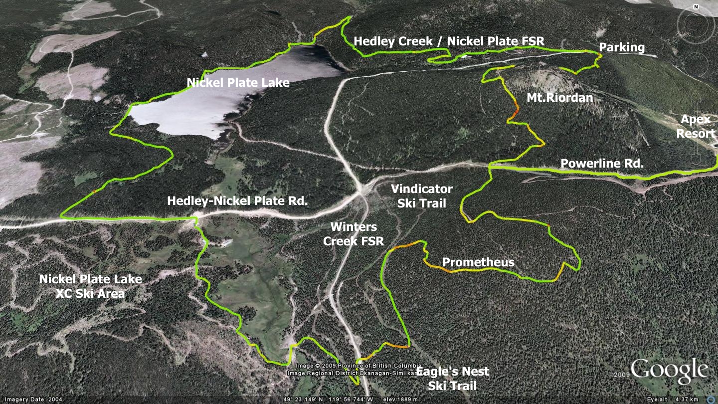
What began with me writing a description of the Nickel Plate Lake trail system, ended up being an examination of an Apex Valley loop covering nearly fifteen kilometers, laid out as I’ve ridden it with friends on many occasions. I elected to present it as a cohesive whole because the various lengths of trail are oftentimes too short to be worthwhile navigated separately, but taken together they can form an excellent loop.
Begin from the old Apex village / upper parking lot. Travel south, heading toward Beaconsfield Mt. (Apex Resort) and its ski runs. At the base of the mountain you’ll have two choices; left or right. Choose the right (north-west) option and proceed along the gravel road, ignoring for now the parallel ski run. The gravel road is called the Powerline Rd. and it runs west through a valley between Beaconsfield Mt. on your left and Mt. Riordan on your right. Two kilometers along, it junctions with the Hedley-Nickel Plate Rd., a location you will visit later in this chapter.
As you make your way along Powerline Rd., you will soon cross a cattle-guard in the road and see an old cabin off to your left. Continue on past the cabin approximately 630 meters where you will see a steep old two-track trail ascending into the forest on your left. This is the Apex service road and your ticket to the Prometheus trailhead, a trail which you may read about in the Prometheus Trail chapter.
Making your way up the service road as far as the Prometheus trailhead, then down it, you will find yourself standing on a narrow clearing - which during warm months appears to be a quad-track but is actually the eastern / upper loop of a long, thin XC-ski trail known as ‘Vindicator’, part of the Nickel Plate Lake XC trail network.
From here you have numerous options - here are three:
- Hang a left and proceed 490 meters south along the Vindicator trail, diving into the well marked singletrack trail on your left, before reappearing on Eagle’s Nest XC ski trail. The singletrack crosses the Eagle’s Nest and plunges back into the forest, quickly arriving at and crossing Winters Creek FSR. Navigate Winters Creek FSR south for 70m, where you will see an opening on your right, take it. Travel approximately 80 meters and plunge back into the forest on a well defined trail. 270 meters in you will hit a small road, head left. This places you in a clearing. Descend across the road (Hidden Mystery XC trail) and just as it ascends, turn right and begin to make your way due north through any trail possible.You are now deep in the Nickel Plate XC ski area and many trails head north-northwest to the main ski lodge from this point. Your only real concern is the boggy area directly to the north-northeast of you - avoid it at all costs. Use a combination of XC ski trails in order to reach the Nickel-Plate XC-ski lodge. Once there, head out of the lodge’s driveway and hang a left at the main gravel road (Hedley-Nickel Plate road). Proceed west (left) five hundred meters to the Claim Jump singletrack trailhead. It appears as an obvious singletrack exiting the road on your right.
- Turn right and follow Vindicator XC-ski trail north approximately 500m to an intersection with Powerline Rd., Hedley-Nickel Plate road & Winters Creek FSR, then follow Hedley-Nickel Plate road thirteen hundred meters west to the Nickel Plate singletrack trailhead. This, perhaps less interesting route, eliminates the possibility of getting turned around in the morass of trails which constitute the XC ski area.
- Turn right and follow Vindicator XC-Ski trail north approximately 500m to a four-way intersection with Powerline Rd., Nickel-Plate Rd. & Winters Creek FSR (as above). Ascend the brief sandy pitch on your right and use the Powerline Rd. in order to return to the top parking lot. Three quarters of a kilometer along the Powerline Rd. you can also choose to connect with the lower section of GBU, using it to return to the top parking lot.
Established December 14, 1938, Nickel Plate Lake Park has been the site of management activities by local rod and gun clubs, as well as government agencies since the 1940’s. For many years it had been a popular fishing spot for residents of Hedley and nearby mining communities like Mascot. The first recorded management activity was the introduction of a freshwater shrimp species in 1944 by the Nickel Plate Rod and Gun Club, these days the lake is restocked with trout annually, providing for recreational fishing. Subsequent actions by the club, and overseen by a game warden, included a program to introduce new species of aquatic vegetation in 1950.
A popular destination for outdoor recreationalists in all seasons, Nickel Plate Lake offers summertime hiking & mountain-biking trails, paddling and camping. Winter activities include cross-country skiing, snowshoeing, ice-fishing and snowmobiling. The north end of the lake is located within Nickel Plate Park, and is dotted with numerous large glacial erratic deposits, compliments of one of the many glacial periods which created the area. Camping facilities include a pit toilet and 5 user-maintained campsites. The Ministry of Tourism, Sports and Arts forest recreation site located at the west end of the lake has better road and boat access and is more popular for camping; “better”, being a relative term.
Friends and I generally access Nickel Plate Lake from the south-west via the ‘Claim Jump’ trail. This brief but fun singletrack route was created by Ron Hayman, Dino and others in order to host a series of cross-country mountain bike races held in the area around 2000. At approximately fourteen hundred meters in length, Claim Jump offers a relatively flat, twisty and fun method of accessing the lake and is enjoyed year-round by recreationalists of many sports. It begins at the previously mentioned point along the Hedley-Nickel Plate Rd., approximately five hundred meters west of the driveway for the Nickel Plate XC Ski lodge.
Once you’ve successfully navigated the Nickel Plate trail to the lakeshore, you will be greeted by a small rock-bottom creek-crossing which provides a refreshing splash on hot summer days. Continue along the weaving & bobbing, eminently enjoyable lakeside trail through the campground and all the way along the western flank of Nickel Plate Lake, to its northern tip.
You will soon arrive at a boggy area with embedded boulders and a board or two wedged between them. If travelling this route on bike I recommend you walk this brief section as I’ve yet to see anyone ride it all the way without falling. I have however, witnessed many people drop a tire into nearly knee-deep mud and hurtle themselves down upon the rocks.
Near the boggy area you will pass a left hand junction to what locals call ‘Lost’ or ‘Secret’ Lake. This small pond lies less than a kilometer up the well surfaced singletrack trail, if you are curious, go ahead and check it out.
At this point you will have nearly reached the northern end of the lake and the park recreation site located there. In order to complete the loop you must follow the Hedley Creek / Nickel Plate FSR in a generally eastern direction, returning to the point at which it junctions with the much larger Hedley-Nickel Plate Rd.
You can choose to stick with the Hedley Creek / Nickel Plate FSR all the way back to where it junctions with the Hedley-Nickel Plate Rd., or navigate it for approximately 1400 meters, then take off on a short right hand jaunt onto the Snowflake Loop. The Snowflake Loop is a brief two-track trail system which roughly parallels the Hedley Creek / Nickel Plate FSR, passing around several small ponds before re-connecting with the Hedley Creek / Nickel Plate FSR.
The only benefit of the Snowflake Loop is that it is slightly more scenic. Either way you’ll soon meet the Hedley-Nickel Plate Road and be ready for the next leg of the journey.
Once back on the Hedley-Nickel Plate road you have a variety of options;
- Use the Hedley-Nickel Plate road to travel three kilometers back up to your vehicle on a well travelled gravel roadway
- Head straight across the Hedley-Nickel Plate road and onto a two-track road and navigate its 1.8k to your vehicle. This is accomplished by travelling through an area known as ‘the circle’ and then riding the paved Apex Mt. Rd. a brief jaunt up to your vehicle
- Finish the route via the Mt.Riordan Bypass trail which, although the longest way back to your vehicle, features a bit more of that gift from the wildlife trail gods: singletrack
This chapter follows the third, most difficult option. Great new singletrack trail discoveries await!
Crossing the Hedley-Nickel Plate road, you enter a parking area which features the Mt. Riordan Service Rd. (SR) at its southeast corner (near an outhouse). Head up this SR for a distance of 190 meters, at which point you will notice a road branching off to the right. This simple three-way intersection presents a major decision point in your travels:
- Continuing 1k straight south along the two-track that you arrived on would find you descending into a residential area known as ‘The Circle’. 200m prior to joining The Circle, this route also allows you to divert to the right, joining low on an abandoned Apex ski run. Trail and run drop together, meeting the Apex Mt. road just below the old ‘top’ parking lot.
- Those wishing for ‘one more climb’ can choose instead to proceed along the right-junctioning Riordan SR. This route climbs around and below the summit of Mt.Riordan, continuing over low sections of its north and west slopes before vigorously dropping to join the Powerline Rd. Two-track components of this route offer opportunities to visit the summit of Mt.Riordan.
Follow this two-track SR road approximately 800m before dropping into a singletrack trailhead which appears on your right. If you were to continue on the road at this point, you would eventually attain the summit of Mt.Riordan, located 1.3k further.
The singletrack trail shadows the Riordan SR for perhaps 800m before crossing a pair of minor two-track routes only 70m apart. Crossing the second of the two, your trail steeply ascends 30 vertical meters before plunging briskly to the Powerline Rd. below. Your vehicle is parked about a 1.5k east of here (a left turn on Powerline Rd.) Riordan sports many more trails than described here - get out there and explore!
Getting There From the Peach in downtown Penticton, head west on Lakeshore Ave. Turn left on Martin St. Follow Martin until it changes its name to Fairview Rd. (you won’t notice). Follow Fairview Rd. across Hwy.97 and follow signs from there to Apex Resort.
Low: 1838m | High: 2051m | Length: 14.5k Loop | Water: Not potable | Cell Access: Full