

Mt.McLellan offers numerous trails to its summit; this chapter describes one of three access routes that I have explored. Like so many landmarks in the Okanagan valley, Mt.McLellan gets its name from one of the areas early settlers, in this case, John McLellan, who arrived in Okanagan Falls with his large family in 1890 and set up the Fall’s first post office in their home.
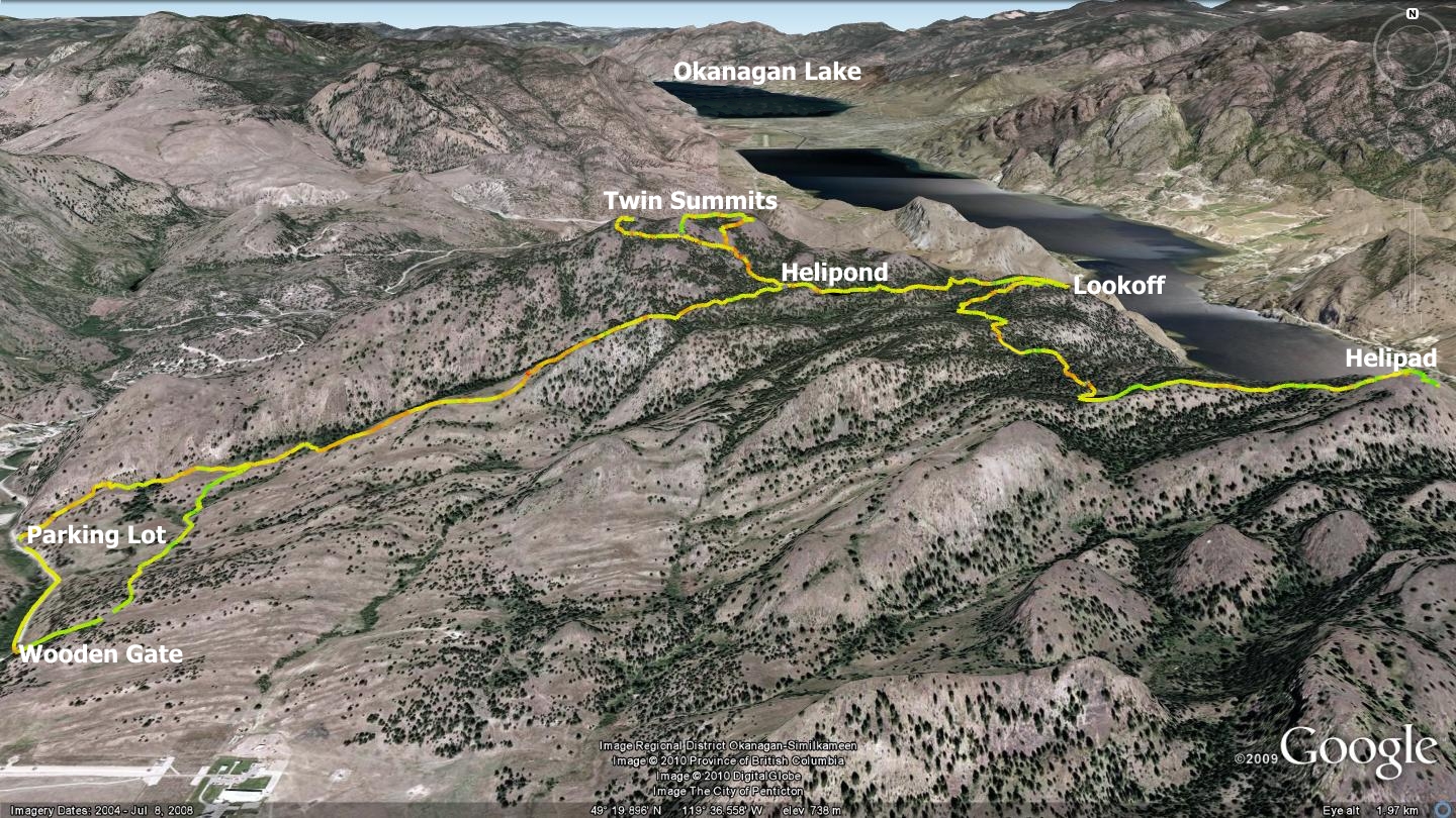
The Mt.McLellan-Helipad trail described here is located on White Lake Rd, approximately 6km from the junction of White Lake Rd. and Hwy97. Parking for the trailhead is on the east side of White Lake Rd., appearing as a short driveway that quickly splits left and right.
Park and visualize the ‘driveway’ that you entered continuing straight through the fence and carrying on toward the mountains. Carefully pass over the fence and follow the faded two-track as it gently rises through Crown land, entering the BC Parks White Lake Protected Area 1.5km from the trailhead. There exist two west-face trailheads to the summit of Mt.McLellan; the one described above, featuring an excellent parking area, but no gate - and other 610m further along White Lake Rd., which does not offer parking, but features a properly built entry gate.
The irony of the current situation is that the gated entry places hikers directly onto a section of land managed by the Dominion Radio Astrophysical Observatory. Past meetings with Observatory management have been less than fruitful; they apparently view trail users on their property (and they own a lot of it in the area) as a security risk. In light of this, I suggest that individuals forego the gated entry point and cross the fence onto Crown land at the parking lot.
Judging by the numerous stumps along its path, I suspect that this two-track is the faded remains of an old logging road. Heading east across open plains and Hawthorne bush, it becomes progressively steeper as it ascends the southwestern shoulder of Mt.McLellan where it eventually enters the forest. There it narrows to a singletrack and meets a small pond in the mountains. My good friend, John Gullick, named this body of water the McLellan Pond, so that is how I shall refer to it throughout this chapter.
You may choose to continue east, alongside and beyond the McLellan Pond, making your way to a lookout point which presents outstanding views overlooking Okanagan Falls and the valley below. Additionally, you may also explore beyond the lookout in order to visit a wooden helicopter practice landing pad (helipad) located 2.6km to the south of the lookout. None of these adventures bring you to the summit of Mt.McLellan however, nor are they the focus of this chapter; they are merely interesting landmarks of the area.
I have included GPS tracks to these features online and indications of their locations in the accompanying map, only because the hike to the summit of Mt.McLellan may seem rather brief to those pining for something more substantial. Be aware that the ‘trail’ to the helipad fades in and out quite often, making the trip something of an adventure; one that should only be attempted by those familiar with the area or equipped with a GPS and tracks available at sweetsingletrack.ca.
Those wishing to ascend to the summit of Mt.McLellan should orient themselves at the west end of the McLellan Pond. The distance between the highest summit of Mt.McLellan and the McLellan Pond is less than 400m as the crow flies. Unlike other trails described in this publication, the section of singletrack between the McLellan Pond and the summit of Mt.McLellan is not clearly delineated by a trail (circa 2010). Instead, a route marked by faded red flagging tape exists, leading one to the westernmost of the two sub-summits that comprise the summit of Mt.McLellan.
It is my hope that visitors will choose to follow along this flagged route in order to minimize social trails and thus the spread of noxious weeds and trampling of plants / compaction of soil. Keep in mind that you are in a unique, protected area of BC Parks and the parks board will view everything that we do to minimize disturbance to plants and animals favorably.
Mt.McLellan‘s two sub-peaks are situated approximately 350m apart, in a line running east to west. Although not apparent when onsite, a study of the GPS and Google Earth maps available online, demonstrates their location and proximity to one another. Both are well worth visiting.
Until the publication of sweet singletrack, Mt.McLellan’s summit was not an exceptionally well-known hiking destination, outside of a handful of local hikers who knew the route. Thus, each group took their own route from the McLellan Pond to the summit of Mt.McLellan. Use of the newly flagged route should eventually establish a permanent trail; a similar singletrack route must also be followed between the sub-summits, as access to this protected area may one day be based on the amount of disturbance we do. Think long-term; act accordingly.
Getting there Beginning at the Peach in Penticton, make your way toward Okanagan Falls. Turn right onto White Lake Rd., located 870m beyond the junction of Hwy.97 and Hwy.3. Detailed descriptions on trailhead access have been provided in the text above.
Low: 563m | High: 947m | Length: 6km Return | Water: Not potable | Cell Access: Spotty