

One beautiful spring day in 2009, I was lucky enough to be guided along the brief but enjoyable Mt.Laidlaw trail by Mike Clyde and John Gullick. Not only did I make great new friendships under excellent weather, but I also discovered a new summit, and afterward, enjoyed a memorable home-brew. Additionally, I enjoyed seeing the first cinnamon bear that I have witnessed in the Okanagan Valley.
As usual, I wanted to know the ‘who, what when and where’ of the mountain I was ascending. The Penticton Geology and Lapidary Club kindly provided this information to me. The following text is excerpted with their permission:
James B. (Jim) Laidlaw joined the Penticton Geology and Lapidary Club in 1962 and was an active and valued member until his death on March 16, 1986. During this time, he held every position on the Executive at one time or another besides being field man for a number of years plus teaching the lapidary and silver-smithing hobby at our Club House. Jim and his wife Grace were made Life Members of the Penticton Geology & Lapidary Club in 1980, in gratitude for their many years of dedication to furthering the lapidary hobby. Jim's working career was spent with the Canadian Pacific Railway and extended over a forty-year period. He became a Cub in 1917 and rose through the ranks. In 1970, he gave up his position as Troup Scouter and became involved in publishing a monthly bulletin called "The Log". In later years, he remained active on the District Council, holding the title of Historian and Personal Research Chairman.
I suggest that you bring along a little something to toast Jim with when you summit this mountain!
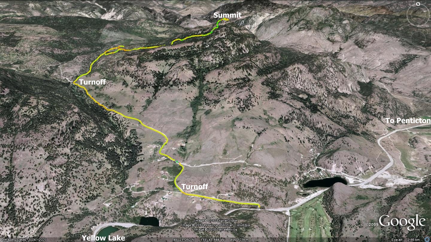
The route to the summit of Mt. Laidlaw begins 3.7 kilometers up Sheep Creek Rd., at which point Marron Ridge Forest Service Rd. (FSR) intersects on your right. Travel a further 1100 meters up Marron Ridge FSR and you will reach a small clearing with a pullout of sorts on your left and an obvious trail leading up and off to your right; this is the trailhead. One is also able to continue 600m further along the FSR, back along a switchback, using a well-travelled road in order to gain additional elevation if desired.
This optional access explains the small loop that you will notice in the accompanying map. I suggest that you begin at the lower parking area as the main trailhead is a little more interesting to hike, and is what I will be describing in this chapter.
Much of the initial section of the trail consists of old dual-track routes through an active woodlot. Single and dual-track trails are abundant in the area and one wrong turn will find you off in who knows what direction. As I so often do, I strongly suggest that you download the free Google earth and GPS tracks available from sweetsingletrack.ca, and use it to guide your journey. Flagging tape and rock cairns exist along the way, but they are intermittent to rare.
From the outset, trails lead off in every direction, thus my constant ruminations about carrying a GPS device. For those of you not interested in GPS technology however, I will do my best to describe the track. I suggest that the Mt.Laidlaw trail is primarily a hiking route, due to the rather sketchy, steep singletrack near the end of the ascent. The two-track trails shy of the summit could however make for interesting XC-ski, snowshoe or equestrian outings.
Heading east from the parking area, your route will dip to the south for a few dozen meters, before reestablishing a generally eastern path of travel. This sections runs for approximately 385m, the last bit of which is singletrack, as it rises to meet an established two-track road. Upon meeting the road, turn right and ascend it for 310m, at which point you will pass an old, decrepit log cabin. Though I spent many hours researching the building, I was unable to determine its history.
Two hundred and fifty meters beyond the cabin one arrives at a ‘Y’ in the path, bear left. The next 850 meters finds your heading alternating north / south as the path gently switchbacks its way up the mountain. Along the way, you will notice several singletrack trails junctioning with your path on the right. Curiosity got the best of me and I investigated these options; it turns out that they simply lead to an immediately parallel dual-track trail in the forest.
Approximately a kilometer beyond the last ‘Y’ junction, you may notice a cairn, along with small bits of ribbon at ground level. This indicates a small look-off to your left, one that is worth a visit, as it presents views across the valley to the west, including an interesting perspective on Apex Resort in the distance. Back on the road, three hundred meters beyond the look-off you come to another ‘Y’ junction; again, stay left. Five hundred and fifty meters beyond the aforementioned junction you find that the two-track you have been walking on fades into the forest and a singletrack trail makes its way up and into thick forest. At this point, the trail becomes steep and somewhat loose as the singletrack trail steeply ascends; a mere 800m of trail is all that separates you from the scenic summit.
The summit of Mt.Laidlaw is actually composed of two heights of land adjacent to one another. The main path shown in the accompanying map will take you to the higher of the two peaks, though a trail also exists on the east face that meanders to the smaller secondary peak. The short hike around the peak is worthwhile as the secondary height of land allows you to gain additional views across the Marron Valley.
One of the interesting things about this hike is though it is rather brief; Mt.Laidlaw’s summit offers interesting vistas in nearly every direction. One can easily circumnavigate the rough, heavily treed summit in order to gain a 360-degree view of their surroundings, as the peak areas are rather small. Though the GPS track provided in the accompanying map depicts a circuitous route atop the mountain, the true path is not actually so straightforward, and a bit of bushwhacking is in order to entirely explore it.
Surprisingly, there is an old, eroded two-track road to the summit. There are also several machined posts and a provincial location marker to investigate. Long time outdoorsmen inform me that prior to the singletrack trail being established, the road was once the main recreational route to the summit. Nowadays, it is overgrown to the point that its existence is only evident near Mt. Laidlaw’s summit.
The return trip is a mirror image of the ascent, so I will not take extra space to describe it here. As with all valley trails, I suggest that you do your part in maintaining the path; kick a stone, move a stick, buff a section if time allows… do your part.
Getting There From the Peach in downtown Penticton, head up Winnipeg St. to Fairview Rd. Follow Fairview to the lights at the intersection of Fairview and Hwy.97 (Channel Parkway). Head south along the Parkway to Skaha Lake and take a right turn. Drive to the intersection of Hwy.97 and Hwy.3a, turn right and follow 3a for a distance of approximately 11.2km. This will place you at the turnoff to Sheep Cr. Rd. Ascend it for 3.7km and turn right onto Marron Ridge FSR. Ascend this FSR for a distance of 1.1km and park out of the way.