

I’ve driven past Mt. Eneas on highway 97, innumerable times - on nearly every occasion glancing up and imagining myself snowboarding down its eastern face. While I haven’t yet experienced my snowy fantasy, in early 2009 Henry Boas, Koko (my pooch) and I finally summited Eneas and enjoyed the amazing views offered from its ridge-top trail.
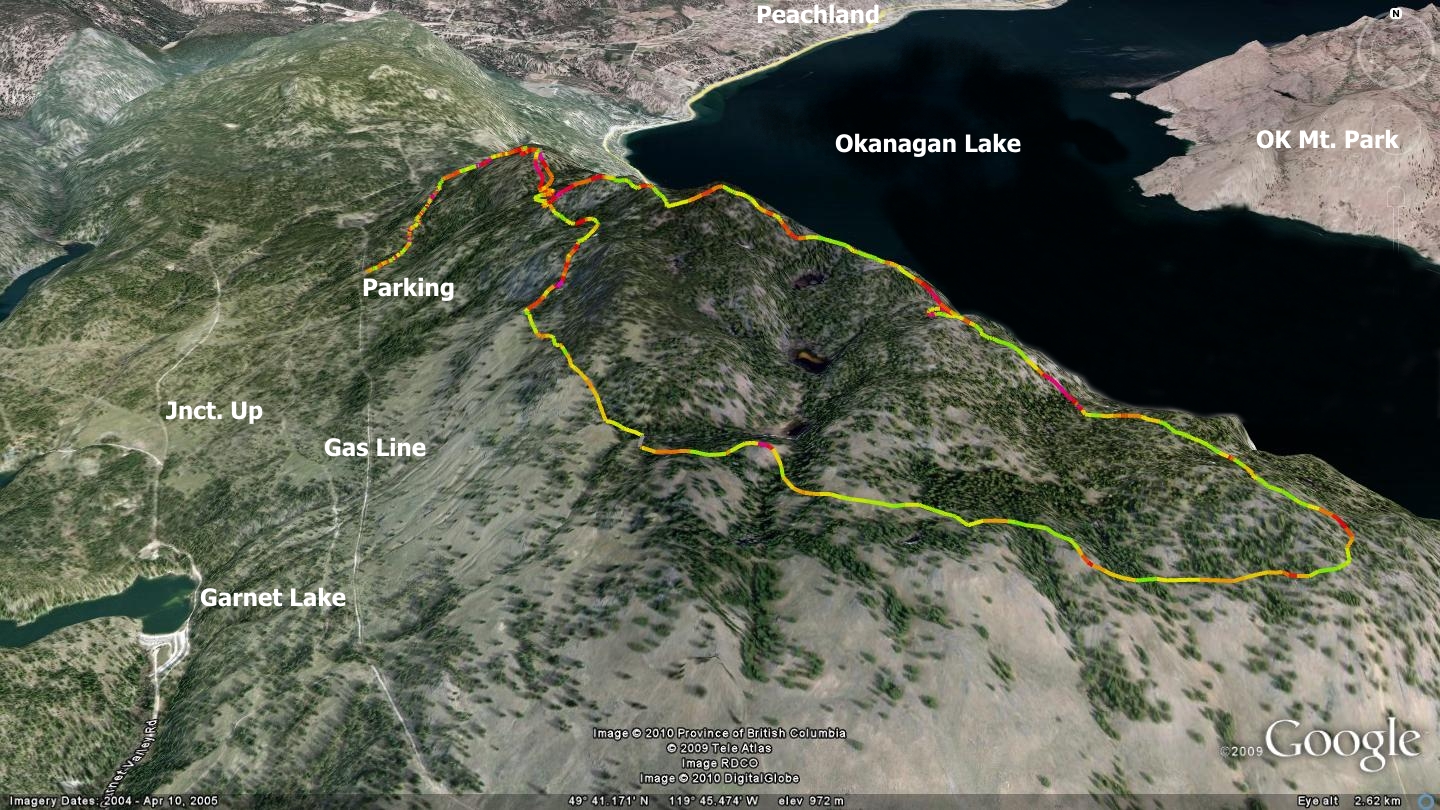
On the journey up I was impressed to see many other established trails in the immediate area. The accompanying map and GPS track barely touch on what is available on-mountain. I am sure that I will be exploring the slopes of Eneas for years to come. Unfortunately, these many trails have not been created without some measure of destruction to the slopes. Many trails in the immediate area are badly eroded, although the ridge-top trail described below is still in decent shape, with the exception of an occasional steep pitch.
Though we hiked this trail, I would welcome travelling it as a hardcore hike-a-bike or winter snowshoe trek. That said, it might not be the best choice for equestrian activities due to several extremely steep and loose sections as well as the constant buzzing of area motorcyclists. I have been fortunate enough to ride horse-back on several great singletrack trails on Wild Horse Mountain further south. Check in with the folks at Wild Horse Mt. Ranch if you are into equestrian.
While the initial two-track road up to the first of several high points is not overly fun to ascend due to pitch, at least it is short. And although the steep decline off the south face of the first peak is a rocky nightmare, revel in the knowledge that it leads to many kilometers of sweet singletrack ahead. Mt.Eneas’ summit and numerous sub-summits are situated near a bend in Okanagan Lake, offering priceless views both north-south, as well as east-west. Its superlative ridgeline singletrack provides numerous opportunities to sit and drink in amazing vistas.
Named after a First Nations elder who lived near the mountain’s southern base until his death in the late 1880’s, Eneas accommodates one of the valley’s rare populations of mountain goats. While mountain sheep are fairly common in the Okanagan, mountain goats are rarely seen. In fact, while I have spent many thousands of hours at various elevations throughout the valley over the last decade and a half, I’ve yet to lay eyes on a single goat in the wild. Local ecologists assure me that there is healthy population in this area, and that the reason I never see them is that goats spend their time on steep, open cliff faces and I don’t. This makes sense.
Accesses to Mount Eneas and its dual / singletrack trailheads are gained via the Garnet Valley Road north of Summerland. Travel up this paved roadway approximately 11kilometers, measured from the last right turn on Jones Flat Rd. (at which point Garnet Valley Rd. begins). At kilometer 11 you will see the southern leg of Garnet Valley Lake, and just beyond it, a small day use campground. This area is a great place to stop, rest and check out the lake. It’s also the last chance to use the facilities before heading up the mountain. The turnoff you seek in order to ascend Mt. Eneas is located 600 meters further along the now unpaved Garnet Valley Rd. It appears as the second two-track road rising from the right hand side of Garnet Valley Rd.
Some may wish to start this trek from Garnet Valley Rd., others such as myself, shorten the trip by driving 950 meters up the aforementioned two-track roadway, parking just shy of the gas line right of way. On the way up you will notice roads which junction to the left and right, ignore them and continue ascending toward the Terasen gas line. It will be evident thanks to Terasen marking posts and an obvious two-track roadway.
The summit of Mt.Eneas lies further up another two-track road, immediately across the gas line. Your route crosses the gas line and continues to ascend an old two-track road. Park near, but not on the gas line, and follow the ascending route in order to continue to the summit of Eneas. From this point on your route to the first high point is well delineated. Do not be tempted - at least this time, to explore the numerous singletrack trails which cross the main two-track you are on. The first of several high points (sub-summits) is located 1.8 kilometers along this two-track road.
This initial sub-summit also represents the end of the two-track and beginning of the singletrack trail. Take this opportunity to drink in the amazing views and rest up, as from this point forward you will gain, lose and regain a great deal of elevation as you circumnavigate Mt.Eneas. Begin descending down the steep, loose south side of this first sub-summit. Rest assured that much of the balance of the trail beyond this point features trail surface superior to this.
It might be worth suggesting that someone - or some group, take it upon themselves to establish a proper switchback hiking trail adjacent to the ‘rockslide’ currently posing as a route to and from this initial height of land.
Approximately 825 meters along the trail you will arrive at a singletrack junction. On your left, the trail begins ascending the mountain. Straight ahead of you, the trail that you are on continues south. Here you must choose to navigate the trail clockwise or counter clockwise. Whichever path you select, you will end up here again - as this is the start / finish of a looping trail which circumnavigates the heights of Mt. Eneas.
In this chapter, the trail is presented as travelled clockwise, so continue by ascending to your left. The trail roller-coasters up and down, delivering you to three separate heights of land; 800, 2000 and 2500 meters distant along the path. Each of these sub-summits offer a different perspective on the valley below, though you may have to wander a few dozen meters off-trail in order to see the views through dense forest. Eventually the trail begins to drop and wrap around the south slope of Eneas, returning along the southwest face to the singletrack junction described earlier in this chapter. Steeply dropping trail, all leading to the Gas Line below present themselves along the way. Ignore them for now.
Getting there Beginning at the Peach in Penticton, take Lakeshore Drive West until you reach the intersection with Highway 97. Beyond the SS Sicamous, the name of the road changes to Riverside Drive. Turn right on Hwy.97 and drive through Summerland until you see the Jones Flat Road junction on your left. Take Jones Flat road due west until it merges with Garnet Valley Rd. at a sharp right hand corner. Drive Garnet Valley Road approximately 11 kilometers to the day-use area and follow the directions described earlier.
Low: 754m. | High Point: 1095m. | Length: 8.5k return | Water: None | Cell Access: Full