

Mount Brent Protected Area was established on April 18, 2001. It is the only alpine area protected in the Southern Thompson Upland ecosection. Within the protected area is an extensive system of wetlands along stream channels as well as very old, low-growing shrub varieties of sub-alpine fir and spruce. Mount Brent was named after Frederick Brent, a former U.S. Army cavalryman who arrived in the Okanagan in 1865. Note its proximity to Apex Resort and Okanagan Lake in the companion overview map.
In this chapter I describe one of three trails leading to the summit of Mount Brent. The trail consists of a steep entry from a parking area, followed by a moderate plateau with flowy singletrack, several swampy creek crossings and a fairly steep push to the summit. The additional access routes alluded to above include an overgrown trail leading in from the south – an adjunct to the Sheep Rock access trail, and very steep route which leads up from the southeast via June Creek.
The majority of the route up to the summit of Mount Brent discussed in this chapter is based on true singletrack trail, unlike numerous routes in the area which interpolate between single and dual-track. As such, it is a real pleasure on foot or bike. Aside from several short, steep stretches, the trail is rideable for fit and experienced cyclists, and is shrouded by lush forest much of the way, providing welcome shade on sunny days. Cattle guards on the road up, plus the sheer volume of fresh patties on the trail remind you that this is grazing territory. Do not harass the cattle and keep your eyes peeled for ‘hazards’ on the trail. Atop Brent Mountain sits a former BC Forest Service fire lookout, adding to the recreational appeal of the area. The lookout building appears watertight, relatively clean and free of rodent droppings, making it possible to overnight in if foul weather prevents your descent. There was previously a guest sign-in book in the building, but as of 2009 it has disappeared. Bring a pen and pad to donate if you’re heading up - you can always take it home if someone else has beaten you to it.
The summit’s outhouse is lacking in essentials. I left my extra toiletries there and suggest you do the same for the sake of the next poor soul in need - it could be you! The 360-degree views from the 2201 meter summit are very impressive and on a clear day you can see mountain ranges hundreds of kilometers distant.
The descent, though tedious on foot, is a wonderland for technical mountain bike riders, as it offers a mix of smooth singletracks juxtaposed between black-diamond technical rock sections. If riding, please keep your eyes open for foot traffic as this is a popular hike. The rugged among you should consider bringing along a collapsible hand saw and pitching in to clear blow-down from the trail.
The trail is rideable both up and down, with numerous, brief sections of push-bike to stretch your legs. The downhill is fast and flowy, but at all times please remain aware of the trail’s popularity.
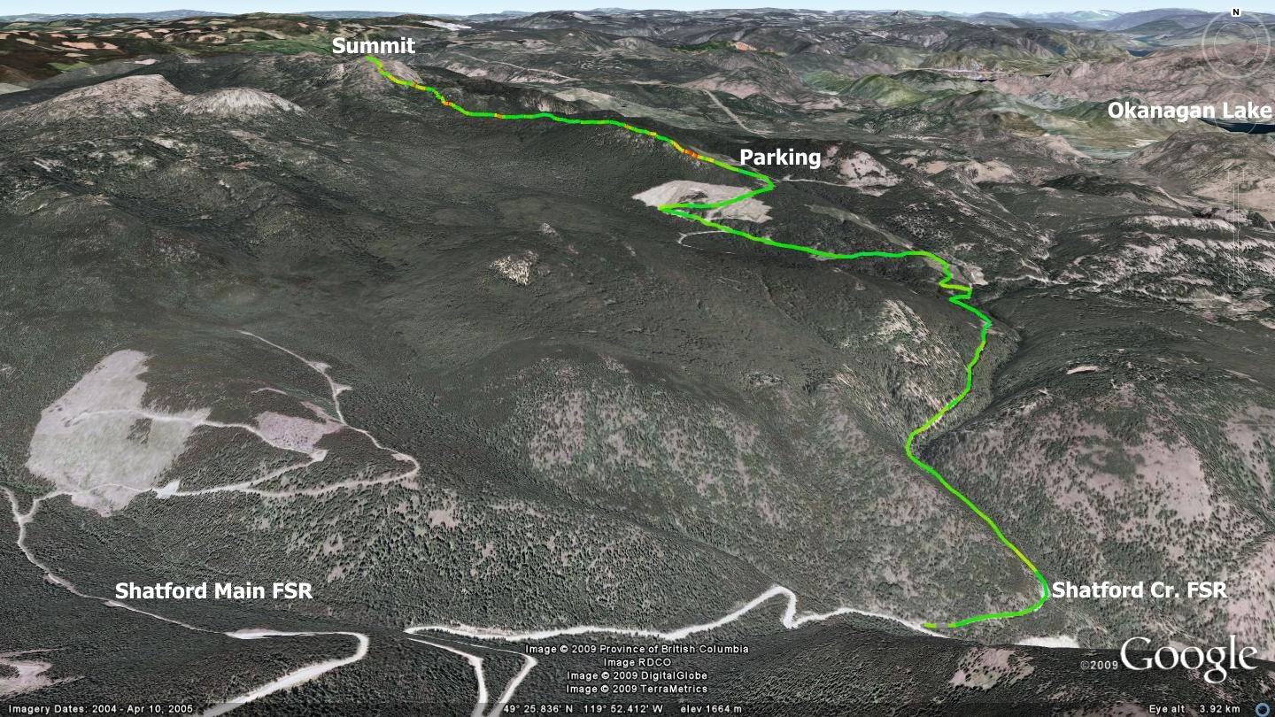
Getting there travel 22km up Green Mt. Rd. from Penticton to a junction with Apex Mt. Rd., then up Apex Mt. Rd for 4.1 km. Turn right on a gravel road sporting a faded stop-sign (Shatford Cr. FSR – as opposed to Shatford Main FSR, which is several kilometers further up Apex Mt. Rd.). Drive 3.7km., turn left. Ignore the right turn at the 4.5km point, as well as the left at km 5.8 and the right at km 6. Go around the hairpin on the main road and right through the clear-cut. The parking lot turnoff is at approximately km 8.2.
Drive in and you’ll notice the obvious trailhead. On the way up to this point you drive past several blue direction signs, including one near the hairpin that directs you to a hike up to the summit of Sheep Rock Mt. I understand that the road into the parking area has significantly degraded since my last visit in 2008.
Low: 1789m | High: 2201m | Length: 9.8k return | Water: not potable | Cell Access: Full