

McIntyre Bluff was named after Peter McIntyre, a retired Pony Express guard who settled near the shore of Vaseux Lake in the early 1880’s. The bluffs are accessible by numerous routes, but in order to discourage trespassing I will only present access via Covert Farms. The 300-acre Covert Farms operation has been in business for close to 50 years (circa 2010) and offers one of the largest organic vegetable selections in the Okanagan Valley. The Covert family has been very gracious in supporting public access to the Rattlesnake Lake and MacIntyre Bluffs trails. This, together with the family’s adoption of organic food production, leads me to encourage all of you to support them in every way possible.
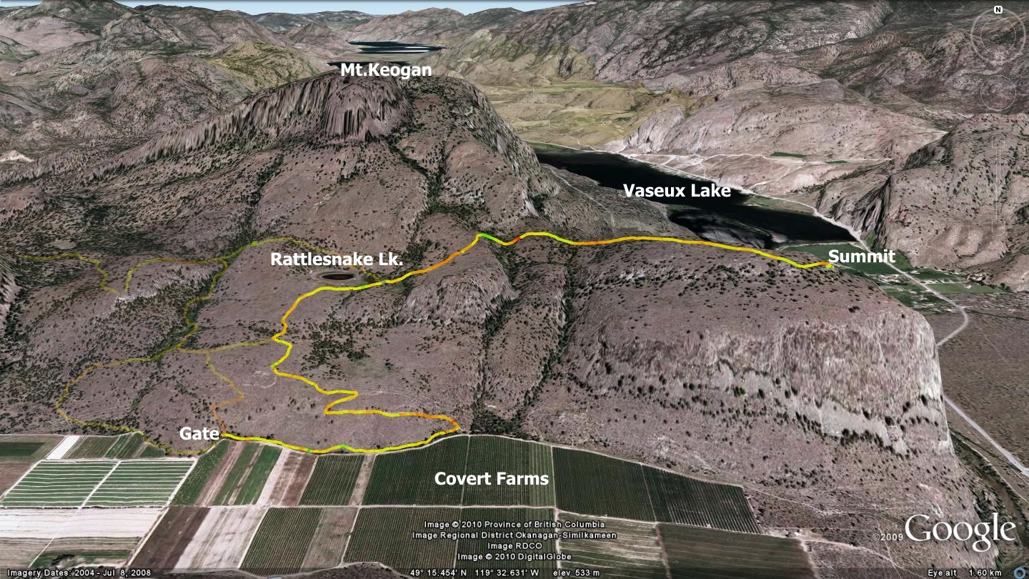
The MacIntyre Bluff trail features an ‘out and back’ layout; meaning that it does not offer the classic looping design of so many other trails described in this publication. It does however, link up with the Rattlesnake Lake loops which are shown as faded tracks in the accompanying map and described elsewhere in this publication. The trail from Covert Farms to the pinnacle of Macintyre Bluff and back runs approximately 8.6km (return); a suitable distance for beginner and intermediate outdoor enthusiasts.
The challenge comes not from the total distance, but rather from the frequent climbing and descending that the route demands. You also need to be aware that this area can become exceptionally hot during summer months; it features one of the hottest, driest sections of trail discussed in this book. If you are determined to travel it in July, August or early September, be sure to bring plenty of water, sunscreen and a decent hat if you are hiking.
Begin your trek by visiting Covert Farms just north of the community of Oliver and ask permission at the office prior to embarking on your journey. This large and busy farm will likely be bustling with workers and equipment, so ask where to park in order to keep your vehicle out of the way while you enjoy the area. 700m beyond the offices and parking area, along the northern perimeter of the main field, you will find a metal gate with trail signage. Employees are likely able to direct you, but a look at the map included with this chapter should keep you on track.
Be extra cautious to ensure that you have firmly closed the gate behind you as you pass through. Like most of the Okanagan, this is deer country and they would like nothing more than to spend time in the lush gardens and orchards below! Be alert for rattlesnakes while in this area. I have enjoyed their presence near this trail on numerous occasions over the years.
Upon arriving at the main entry gate, you have three choices: left, right or straight up. I advise that you hang a right and follow along the edge of the fence in a generally eastern direction. Along the way, you will navigate an entertaining length of twisting and undulating singletrack and pass through the largest stand of Sumac trees that I know of in the Valley.
After travelling approximately 650m along this singletrack trail, you will arrive at a two-track roadway rising from a farm gate on your right. Turn left and ascend the two-track, which throws a few steep pitches your way before flattening out near Rattlesnake Lake. The lake is likely to be a dried up depression if you visit the area anytime after June.
You are now entering BC Park’s Grasslands Protected Area. Wide swaths of the land all around you are under protective land covenants; The Nature Trust, Canadian Wildlife Service and The Land Conservancy all have ongoing interests in the region. We need to exercise special precautions when we recreate in these areas or risk losing access altogether. This area’s grasslands and open pine forests represent one of the four most endangered ecosystems in Canada.
The rolling, rocky landscape is a Class 1 lambing area for California bighorn sheep and a mule deer winter range. The area abounds with endangered wildlife, containing numerous red and blue-listed species. The list includes two amphibian, five reptile, fifteen bird, eight mammal and three species of bat.
Just east of Rattlesnake Lake the trail splits. A left hand singletrack heads to the northwest and the highest of the Rattlesnake Lake trail loops, while a right hand singletrack trail leads to McIntyre Bluffs. You will undoubtedly notice the wooden trail information posts situated at most intersections. This signage was erected through a collaborative effort between BC Parks, Mountain Equipment Co-Op and the South Okanagan Bike Club. It will guide you along the way as you travel east toward the actual Bluff area.
Quite near the Bluffs, you will see a sign stating that you cannot bring mountain bikes beyond that point. Please pay attention and obey this simple request as it benefits not only the animals in the area, but ensures your safety and our future access to the land.
From here on, the property you will be crossing is owned and managed by The Nature Trust, and they have final say on where we can wander. Stick with the established trails and everyone will be happy.
If you are set to enjoy the trail with a mountain bike, bring along a lock so that you may secure your bike to a nearby tree while you hike the short distance to the actual Bluffs. From here, the jaunt to the edge of the bluffs is a mere six hundred meters, and if you rode this far up, you will likely find the walk to be a welcome relief. MacIntyre Bluffs offers some of the most amazing views and stunning sheer cliff drop-offs of any height of land in the area. Once you have arrived at the end of the trail, you will understand why it is so popular.
Upon descending, stick with the route that you ascended on, or divert onto the Rattlesnake Lake Loops prior to returning to Covert Farms. If riding, please keep your speed in check as this is a very popular tourist destination and there are bound to be others on-trail.
There are several additional methods of accessing MacIntyre Bluffs; none of which are promoted by this publication as they all exhibit land use issues:
- From below, via the old CP railway bed. This is not advised, as you must cross Canadian Wildlife Service lands which are permanently closed to the public
- Via Willowbrook. This land belongs to the Willowbrook Society. You must be a Willowbrook Society member or have specific permission from a member in order to cross this property
- Descending from the eastern shoulder of Mt.Keogan. This is a rough, undocumented, ‘hike-only’ route. Access is frowned upon by BC Parks
Getting there From the Peach in Penticton, drive south on Winnipeg St. to Fairview Rd. Stay on Fairview until it meets the Channel Parkway (aka Hwy.97) Drive Hwy 97 south out of Penticton toward Okanagan Falls, located approximately 16km south. Drive through OK Falls and continue south toward Oliver. Turn right on Seacrest Hill Rd., follow it until you see the Covert Farm signs.
Low: 424m | High: 665m | Length: 8.6km return | Water: none | Cell Access: Full