

This chapter indicates the Mahoney - White Lake trail as being moderately difficult; but only because it contains several steep and loose climbs. Individuals of advanced fitness levels will view it as a beginner’s trail. The main body of the route consists of gently rolling terrain with a few brief but challenging hills. Individuals in decent physical shape will be able to hike, push-bike or ride these sections. With decent snowfall - rare at this elevation, the loop also makes for excellent snowshoe and XC-ski terrain.
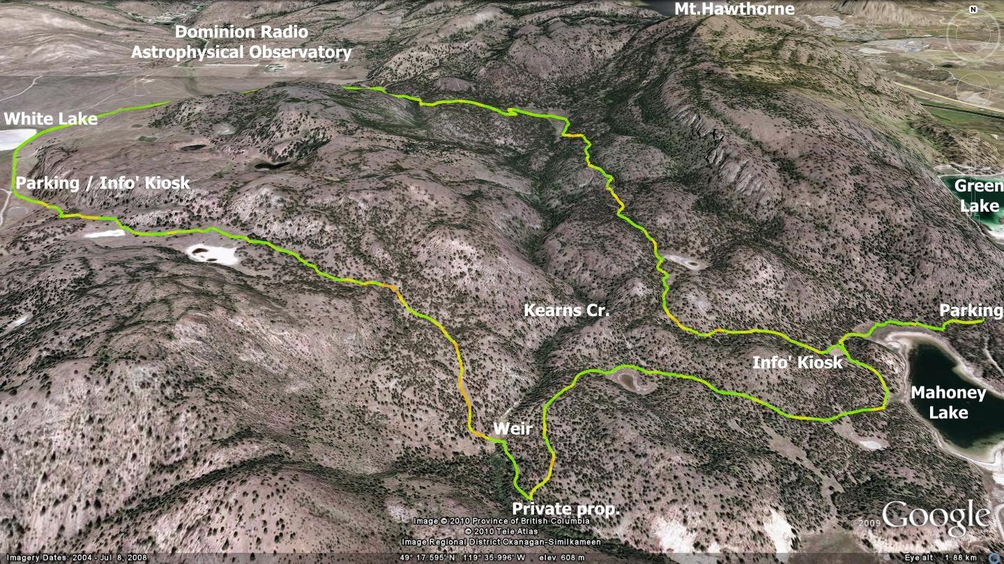
The trail may be attempted from either side; beginning on the east via Mahoney Lake or from the west access adjacent to the parking lot at White Lake, near the Dominion Radio Astrophysical Observatory. Both sites feature interesting landmarks.
On the east, Mahoney Lake Ecological Reserve was established to preserve the unique features of one of BC’s most interesting saline lakes. Its upper waters are clear and support a wide diversity of plant and animal life, but between the depths of 8m to 8.5m, a layer of purple sulphur bacteria forms a dense plate extending across the entire lake. The waters beneath the bacterial plate are anoxic, dark and rich in hydrogen sulfide, with some of the highest concentrations of this chemical ever recorded in the world. The water below the plate is extremely salty and devoid of life save for certain bacteria that exist without oxygen.
On the west side lays the National Research Council of Canada’s Dominion Radio Astrophysical Observatory (DRAO). This array of antennas was established in the basin in 1959. It is operated by National Research Council Canada (NRC) through the Herzberg Institute of Astrophysics. DRAO's purpose is to study the cosmos though natural radio emissions from space.
White Lake itself is but one of many saline lakes in the area. Saline lakes form in grassland depressions where there is no means for the collected water to escape. The surrounding soils feature elevated levels of soluble minerals, salt among them, which accumulate as the lakes fill with spring runoff. The region’s hot, dry summers cause the rate of evaporation to exceed the rate at which moisture accumulates in the depression. As the water level drops, the exposed minerals whiten the lakebed.
With such interesting anchors at either end, the landforms, flora and fauna which lay between are icing on the cake.
The west entrance is complete with an information kiosk. The route begins as a singletrack trail which soon ascends into the grassy foothills southeast of White Lake. The trail morphs in and out of dual-track as it makes its way along. Within the first kilometer you begin to see small ‘white lakes’ on your right. If visited in the spring, the floral show is spectacular!
The trail meanders up and down for the first two kilometers. If on foot you will have no problem; if riding, there are several tough hills to ascend along the way. At approximately the 2km point you reach a long and mildly steep pitch which drops to a small weir on Kearns Creek. This is a good spot to rest and observe the wildlife on or around the small body of water behind the dam. I once met a fellow who swears he saw what appeared to be a wolverine drinking out of the pond! I would have been hard-pressed to believe it if not for the animal being listed on the South Okanagan Similkameen Conservation Program website.
At this point you have two choices; cross the weir and begin to ascend the singletrack trail you see on the bank ahead of you, or follow the road around for a distance of 250m, then turn left and ascend. I prefer the singletrack trail, but those who choose the road option must be aware that property beyond the aforementioned ascending left turn is private and is to be avoided.
One kilometer along this road you will pass another alkaline pond, continue beyond it where you will find a road dropping to meet your path on the left. This short-cut back to the Observatory is irrelevant at this point. 500m beyond the lake to the east, a road peels off to your left. Ignore it; this route arrives at the same spot I am about to describe. 400m further along the road, you will arrive at Mahoney Lake. Head north from there, staying on the same road you used to enter the area. 320m beyond it you will arrive at an intersection and clearing which hosts an information kiosk and full description of the area. If you were to travel this road further northeast, you would arrive at Green Lake Rd. and the commonly used eastern entrance to this trail network.
Head west, then north from the information kiosk, keeping to the two-track roadway. One kilometer along you will find yourself at another white-lake. Just shy of it, a trail joined on your left - that was the ‘short-cut’ trail mentioned earlier. Refer to this general trail description if you are entering from the Mahoney Lake side of the trail network.
Stick with the main road, heading north-northwest of the previously described white lake. It continues to head north for 1.6km. At this point you enter a marshy area, skirting its eastern shore on a very well delineated singletrack trail. The route bears left (west) along the top of the marshy area, hugging the tree line, before turning and ascending south. It runs south for 160m, at which point it turns sharply to the west, runs 70m, and then heads northwest. This zigzag is simply a means of ascending the height of land without going straight up.
The route arcs gently west for the next 500m before turning sharply to the north and following the edge of Kearns Creek Canyon. The trail is quite obvious for the next 800m. At that point you will arrive at a creek crossing. Gently cross the creek (you are in Nature Trust Land here) and make your way west. 400m later you will pop out into an open basin. The observatory is to the northwest; your vehicle is south of you. The road back to trailhead is very obvious; just keep an eye out for singletrack which shadows the road on your left for much of this distance.
In case you are wondering what I am doing by directing you onto Nature Trust managed lands, here is the story, verbatim from their trailhead kiosk: “within the bio-ranch property, hiking on existing trails is welcome”. This trailhead kiosk does not mention mountain biking, but the BC Parks website does, stating that “Cycling is permitted. Recreational mountain bikes are allowed on designated roadways”. Please be aware that both BC Parks and Nature Trust are very keen to avoid spreading noxious weeds and seeds in the area. As such, keep whatever means of (non-motorized) transport you choose to navigate these route on clear of ‘hitch-hikers’.
Getting there from the Peach in Penticton: Access the observatory from the Peach by driving south on Winnipeg St. to Fairview. Drive Fairview to the Channel Parkway and stay on it to Skaha Lake Rd. (Hwy.97). Take Hwy 97 to the junction of White Lake Rd. (on your right, 900m beyond the Hwy. 3a junction). Drive White Lake Rd. for 9km and you are there. Mahoney Lake uses the same route, but skips the White Lake Rd. junction and carries on towards Okanagan Falls. Turn right onto Green Lake Road - just before the bridge on the outskirts of OK Falls. A roughly 7k jaunt down Green Lake Rd. puts you at Mahoney Lake on your right.