

When Placer gold was worked along the Similkameen River during the 1860's, the oxidized mineral staining on nearby Nickel Plate Mt. attracted the interest of prospectors and geologists and the first on-mountain claims were staked in 1894. Ore of commercial promise was discovered in 1898 just below and east of the summit, when prospectors located the Nickel Plate. Samples shipped to Victoria were examined by geologic engineer M.K. Rodgers and what he saw upon visiting the Hedley area prompted the optioning of the Nickel Plate claim and subsequent exploration and development. Nickel Plate mine operated as an underground mine before 1930 and from 1934-1955 and open pit mining commenced in 1987 from 3 pits. The Nickel Plate and associated ore bodies have yielded over 2.5 million ounces of gold from both underground high grade and surface open pit production. The mine has experienced a number of closures and subsequent reopenings in the years since it was created, the most recent closure being 1996. As of 2010, the mine remains shut down.
This brief history lesson explains much of what you will see upon summiting Lookout Mt., one of the many interesting peaks to be climbed near Apex Resort.
It must be noted that the map which accompanies this chapter will seem deceiving when you compare it to what is currently (2010) presented in Google Earth. Several of the clear-cuts shown here are new and do not currently appear in Google Earth. I have used a graphics application in order to add the new clear-cut to this map, thus facilitating my description and orientation of the trail. An up to date overview of the area is available by visiting Microsoft’s ‘Bing Maps’ page at bing.com/maps
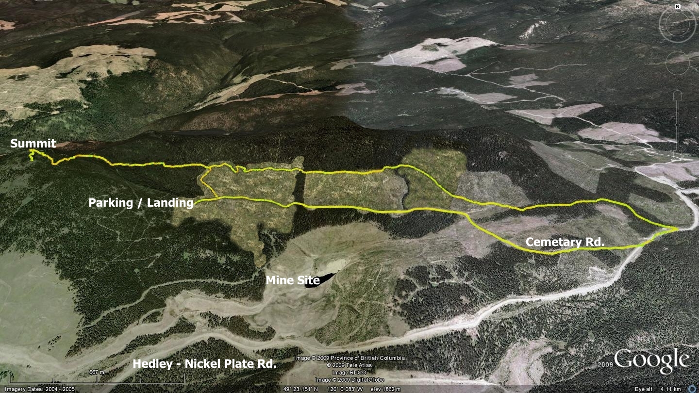
The clear-cuts play an important part of this hike. One has the choice of beginning their trek from the Hedley-Nickel Plate road at the classic trailhead, crossing the clear-cuts in the process; or driving to the landing at the end of Cemetery Rd. and hiking up to the alternate trailhead. The classic route in forces you to cross some rough, but well-marked terrain. It also allows some insight into what a clear-cut looks like up close, something that I suspect few have ever witnessed first-hand.
The alternate trailhead is much more direct, but still entails a brief hike up the edge of one clear-cut in order to reach the alternate trailhead. Trail markers across the clear-cut areas have recently been refreshed, so I do not see anyone experiencing great difficulty making their way across them - be forewarned however, that the terrain is quite rough.
The classic trailhead meets the Hedley-Nickel Plate service road (SR) at a point 2.1km beyond the driveway to the Nickel Plate Lake Nordic Center. It currently takes on the appearance of an old, overgrown two-track road. Here you will see an entrance into the forest and a red and black ribbon in the tree to the left of it. If, on the other hand, you wish to make your way to the alternate trailhead, proceed 350m further along the Hedley-Nickel Plate Rd., where you will note a small cemetery on your left, as well as a cattle guard in the road. Just beyond the cattle guard, Cemetery Rd. splits off to the right.
Turn right and navigate this old forestry access road for 1.1 kilometers, where you will arrive upon a fork in the road - keep left and continue for a further 1.8 kilometers from the original turnoff from the Hedley-Nickel Plate Rd., to a loggers landing area. Be aware that this last 1.8km is officially decommissioned and has been cross-ditched. The road surface is smooth enough, but the cross-ditching demands a vehicle of substantial clearance. The landing which terminates this road currently offers more than sufficient parking, though I cannot say what it will look like in the near future as logging activities may modify this area further.
Once parked at the landing, back-track down the SR several dozen meters and look to the northwest. There you may notice a small stream (Sunset Cr.) coming down the mountain and passing under the road. This creek runs through the forest near the edge of a clear-cut and delineates your route up to the alternate trailhead. Note that there are short sections of old skidder trails into this area as well. Head up and along the edge of the uncut forest (2010) making your way to the upper northwest corner of the clear-cut in order to locate the main body of the hiking trail. Once there, you will find ribbons of red flagging tape with black dots marking your entrance into the forest. Kudos to the Penticton Outdoor Club for all of their hard work in creating and maintaining this trail.
The short, steep fifty meters in elevation you will gain between the parking area and the alternate trailhead is the toughest part of this hike. From there on you will be hiking for the most part on a fantastic and quite obvious singletrack trail.
660m along this singletrack trail you will meet with an old two-track road. Turn right and head up this road (northwest) for a distance of approximately 130 meters where you will find an FSR ascending; ignore it and carry on a further 55m. There you will find a marker indicating a singletrack trail leading up and to the left. Follow this trail into the forest, continuing your ascent.
Within 140m you will meet the FSR which you earlier ignored. Head up the mountain on this FSR for approximately 70 meters, at which point you will see another forest singletrack entrance on your left, enter it and you are on your way to the summit less than a kilometer distant. One could actually continue up this two-track roadway and arrive at the summit. It is just that the singletrack is more interesting and aesthetically pleasing.
Lookout Mt. sports some excellent vantage points, though stunted trees are conspiring to hide vistas in various directions and one must hike around the summit in search of the best views. Despite the brevity of this singletrack trail as a whole, I would not hesitate to recommend this hike to recreationalists who are in the area; perhaps visiting Apex Resort during the summer or for the extremely hearty; snow-shoeing in the winter.
As a big fan of singletrack trails with solid surfaces, especially routes which provide views as stunning as this one at their endpoint: Lookout Mt. trail makes the grade on all accounts.
Getting There: Travel from Penticton to Apex Resort. Once at the resort, ignore the well-signed left turn to the Apex Village and ski lifts. Instead, continue up and to the right, staying on the main Apex Mt. road and making your way as far as a major intersection where it switches back tightly and rises to your left, while Nickel Plate road continues straight ahead (north). At this point the road straight ahead turns to a gravel route. Stay on the Hedley-Nickel Plate Rd. for a distance of 6.5 kilometers, at which point you will see the Nickel Plate Lodge XC Ski Club Nordic Center on your left. Continue past it to either the classic route up or the Cemetery Rd. turnoff and follow the descriptions in the main text above.
Low: 1828m | High: 2052m | Length: 5K Return | Water: Not potable | Cell Access: Mostly