


Updated: See bottom of this write up.
One beautiful summer day in 2009 I was lucky enough to be invited by the Penticton Outdoor Club to experience their particular method of exploring the summit of Little White Mt. The club created and maintains a pair of rudimentary trails up the southeast face of the mountain – one route up and another down. Considering that it’s roughly a 50-kilometer drive from Penticton to the parking area, this isn’t the most convenient hike. It does however offer some of the best views of Greyback Mt., Myra-Bellevue Provincial Park and its attendant trestle system, as well as Okanagan Lake and south Kelowna. I found myself wishing for a set of binoculars as various interesting distant views, including several of the Myra Canon trestles, beg closer inspection.
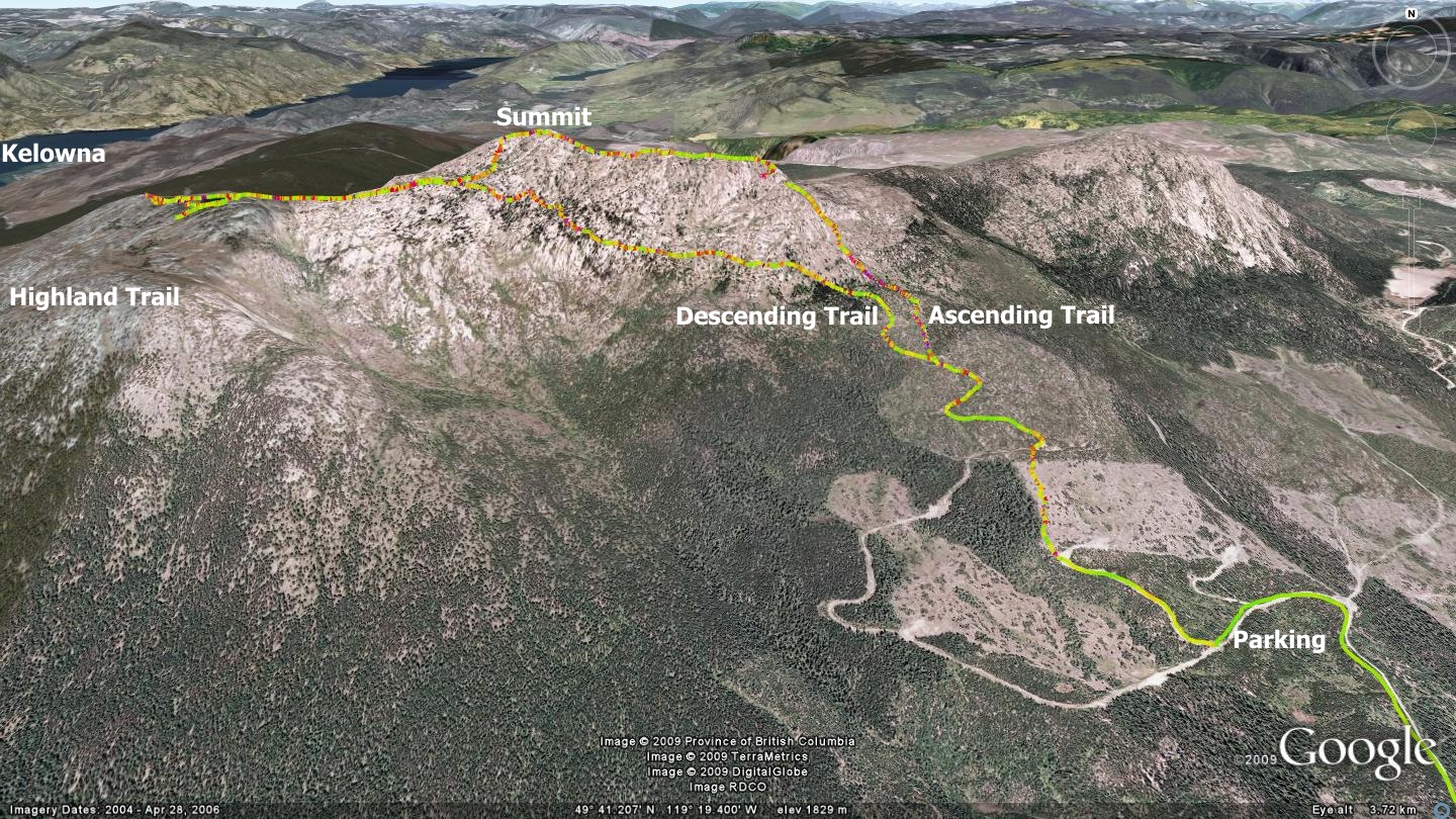
The route that I describe here begins at the intersection of Carmi Ave. and Government Rd. From there, continue approximately 6.2 kilometers up Carmi Ave and turn right onto Beaverdell Rd. Drive a further 16.8 kilometers east on Beaverdell Rd. until it meets the Okanagan Falls Forest Service Road – what locals refer to as “the 201”. Turn left on the 201 and proceed approximately 19.7 kilometers to Greyback Mt. FSR junctioning on your left. Turn onto Greyback FSR (aka Road 202) and proceed approximately 2.6 kilometers along it until you see a junction on your right called Canyon Lakes FSR. Travel Canyon Lakes FSR 1.5 kilometers, to where a small left hand turnoff and a narrow trail leads into the forest.
This unnamed and decommissioned road presents 29 cross ditches between this turnoff point and your ultimate parking spot. As such, I can only recommend this next section to those with capable, high-clearance vehicles. If so equipped, proceed up the narrow road. Ignore the left hand turn at kilometer 1.4 and continue. Ignore the right turn at kilometer 3.2 as well as the one at kilometer 3.4. Proceed until you reach a junction at kilometer 3.6. At this point you will see that the road proceeds ahead, and a blocked off road climbs on your right. Park your vehicle as this is where you will begin your hike.
Ascend the blocked off road mentioned above for 390 meters, to a point at which the road curves off to your right and a singletrack trail makes its way up the steep embankment to your left. At this point the Penticton Outdoor Club’s red and black dotted flagging tape and rock cairns should be evident. This is the beginning of the actual singletrack trailhead which will allow you to summit Little White. If the description to this point sounds convoluted, I’d suggest that you use a hand-held GPS device, along with the free tracks for this hike hosted at sweetsingletrack.ca
Approximately 400 meters in you will happen upon an old road. Turn right and proceed across it and upward – always looking for the hiking club’s flagging tape on tree branches and rock cairns atop boulders. Five hundred meters along is another road – bear left and proceed up. One hundred and fifty meters further is a junction of sorts – ascend the route to the right. The ‘left option’ is where you will arrive when you descend at day’s end.
From this point forward you are on a singletrack trail heading through the forest. Three hundred meters in you pass a Park Boundary sign as you enter the Myra-Bellevue Provincial Park. 1.5 kilometers later you cross a well-established trail which intersects your route at right angles. This is the Okanagan Highlands trail system, to be described in a future edition of Sweet Singletrack. Signs from the Friends of the South Slopes (foss-kelowna.org) indicate this section of the trail.
At this point the trail becomes what might best be described as ‘creative’ - as well as scenic. Our troop ascended the very steep cliffs, heading south and then west as we scrambled up the rock faces. The group that day mainly consisted of seniors, was led by an 81-year-old trail leader, and included Dr. Brad Houston (club past president, 80) and many others over 70 years of age. I remain impressed and can only hope that I am as willing and agile in my golden years!
Within several hundred meters you will see a massive granite wall, indicating a sheer drop to your right, roughly in the form of a cirque. This natural feature faces to the north, and hosts a small tarn - a clear alpine pond nestled in the hollow of the cirque. At this point the various radio towers atop Little White’s summit are also obvious. Make your way up and drink in the stunning 360-degree views. Unfortunately, now only a foundation of rubble remains where once sat a small outbuilding. A rough 4X4 road running up from Kelowna enables delinquents to reach the summit and vandalize objects there at will. A small pond sits atop the summit, offering an excellent place to cool off on a torrid summer day.
From the summit, follow a fairly vague rock cairn route down and to the southwest, towards Crawford Lake and numerous ponds along the way. At Crawford Lake you will find a great R&R spot as well as further signage indicating another section of the Highland Trail, in this case, erected by the Western Canada Wilderness Committee (wildernesscommittee.org). The day I hiked Little White with the club members, we scaled every diminutive peak in the area, of which there were many.
In order to locate the trail which descends to your vehicle, double back on the vague trail which you followed to make your way to Crawford Lake, but only as far as the first pond you came upon as you descended from the summit. Seek out the flagging and rock cairns which lead you across the southern face of Little White Mt., heading east-southeast. Once located, this rough-hewn singletrack trail crosses what appears to be an impassible face until it meets up with your original route up Little White, southeast of the summit. At this point you should be able to recognize the route and can make your way down to your vehicle.
Overall, I would rate this as one of the more enjoyable hikes in the Okanagan, due to the abundance of excellent views from the summit, the many ponds along the way, an abundance of wildflowers in the early summer as well as a varied and interesting trail surface. Its intersection with the Highland Trail system also greatly intrigues me. Look for more information both the Highland and High Rim trail in subsequent editions of Sweet Singletrack.
Updated: I've recently explored the summit of Little White Mt. via the Highland Trail, leading up from Canyon Lake, and would recommend that you first attempt this route, as it's easier overall, and provides a quality parking area. This 'new' route is shown as an orange line on the maps attached to this web page.
Please be aware that the Canyon Lake FSR. has not been maintained for anything other than 4X4 and all-wheel drive vehicles with (lots) of clearance. Canyon Lake FSR even gave the little Subaru a run for it's money!
The route into the Canyon Lake parking area is very similar to the route described in the original write up above. Turn off Rd. #201, onto Greyback Mt. Rd., and continue 2.6km, where you'll see a right-hand junctioning road; this is Canyon Lake FSR. Travel up Canyon Lake FSR for a distance of approximately 5.25km, where a parking lot will appear on your left. Head up!
This is a very hike-friendly route for all skill levels save rank beginner, a serious hike-a-bike for mountain bike riders and a very challenging route for highly experienced equestrians!
The trail is within the Myra-Bellevue Provincial Park, and as such, is signed all the way to the summit, as such, you should be a-ok as far as navigation.