

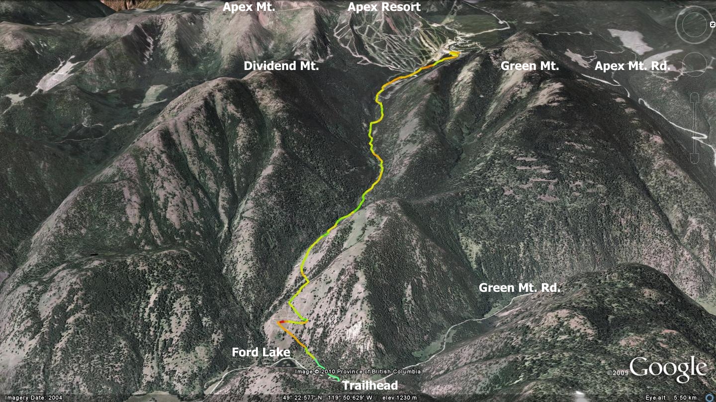
Years ago, while returning from a day of mountain biking at Apex Resort I was struck by the apparent waste of vertical as we descended Apex Mt. Rd. to the valley in a friend’s vehicle; this, amidst rumor of an excellent creek side route to Green Mt. Rd. Fast-forward to 2010; after several exploratory descents of the Keremeos Creek forest service road (FSR) I found that it is indeed a quick and exciting route from Apex Resort to Green Mt. Rd., 838m below.
The route is now one of my favorite methods of exiting Apex Resort after a long day of singletrack riding in the subalpine. As this 9.2km descent plunges between Green & Dividend Mts., its near-constant pitch offers the potential of incredible speed. Reliable braking systems are a must, and you will require confident bike handling skills as this pseudo-two-track sports everything from hard-pack gravel surfaces to singletrack with rock strewn corners. I have yet to descend the route on cross country skis or snowboard, but see no reason that it could not be traversed in this manner, as long as ample snow exists and you have a shuttle vehicle awaiting your arrival at its Ford Lake terminus. Hikers and equestrians might also find its route of interest.
The descent begins from the northeast corner of the Apex Resort / village parking lot, just to the right of a small structure with livestock fencing adjacent to it (ski-doo rental in the winter and previously an equestrian center). The Keremeos Creek FSR initially takes on the appearance of a common gravel road, but the surface consistency changes significantly within a couple of kilometers. Soon you will find yourself plunging down a drainage ditch laden two-track that twists and turns as it races to Ford Lake far below.
At times, the route narrows to something akin to a singletrack trail before resuming as a full speed ahead two-track. Numerous cross drainage ditches appear as gently sloped depressions; too wide for a flying bunny-hop, but large enough to cause a loss of control if approached incorrectly. One soon figures out a cadence that will allow negotiating them without too much trouble.
While these are certainly an improvement over the ditching found on many decommissioned forest service roads, they are still not to be underestimated. Several of these 80 plus drainage ditches appear to have been maintained by hand and shovel after the fact. As such, while it is easy to get the hang of navigating them, one must be on the lookout for the oddballs randomly thrown into the mix.
At the speeds commonly attained on this route, a moment of inattentive navel-gazing will find you diving off a massive cliff, heading into a rock cut or plowing into one of the many bovine obstacles and their attendant dung.
As you hurdle down the mountain, you will see various roads intersecting on your left and right. Some of these routes lead only a short distance into the forest, while others eventually make their way to the summit of Green Mt. on your left, or Dividend and Apex mountains on your right. I have not explored all of them, but my experience in the area has determined that routes leading to these summits are uniformly steep, rocky and extremely tough going.
The best advice that I can offer is to stick with the main route down; it is dead obvious and far more enjoyable. If you find yourself ascending any significant slope while on the Keremeos Creek FSR; then you are on the wrong road. Astute observers of the on line GPS / Google Earth tracks will notice that, upon close inspection, some sections of the GPS track appear to be aberrant. This irregularity is a side effect of recording GPS tracks in steep, narrow valleys. While on site however, the route is easily identifiable, so this should not pose a problem to navigating it.
Be aware that there is often a cattle gate across the road about two thirds of the way down, as well as another near the bottom of the FSR; leave them in the position that you found them.
Notice that the accompanying map has been rotated so that north appears to the right of the screen. This turned out to be the best angle to present the route in its entirety.
Getting there from the Peach in downtown Penticton – head up Martin St., following it until it changes its name to Fairview Rd. (you will not notice). Follow Fairview Rd. to the intersection with Hwy.97, then cross it. Signage will guide you from there to Apex Resort.