

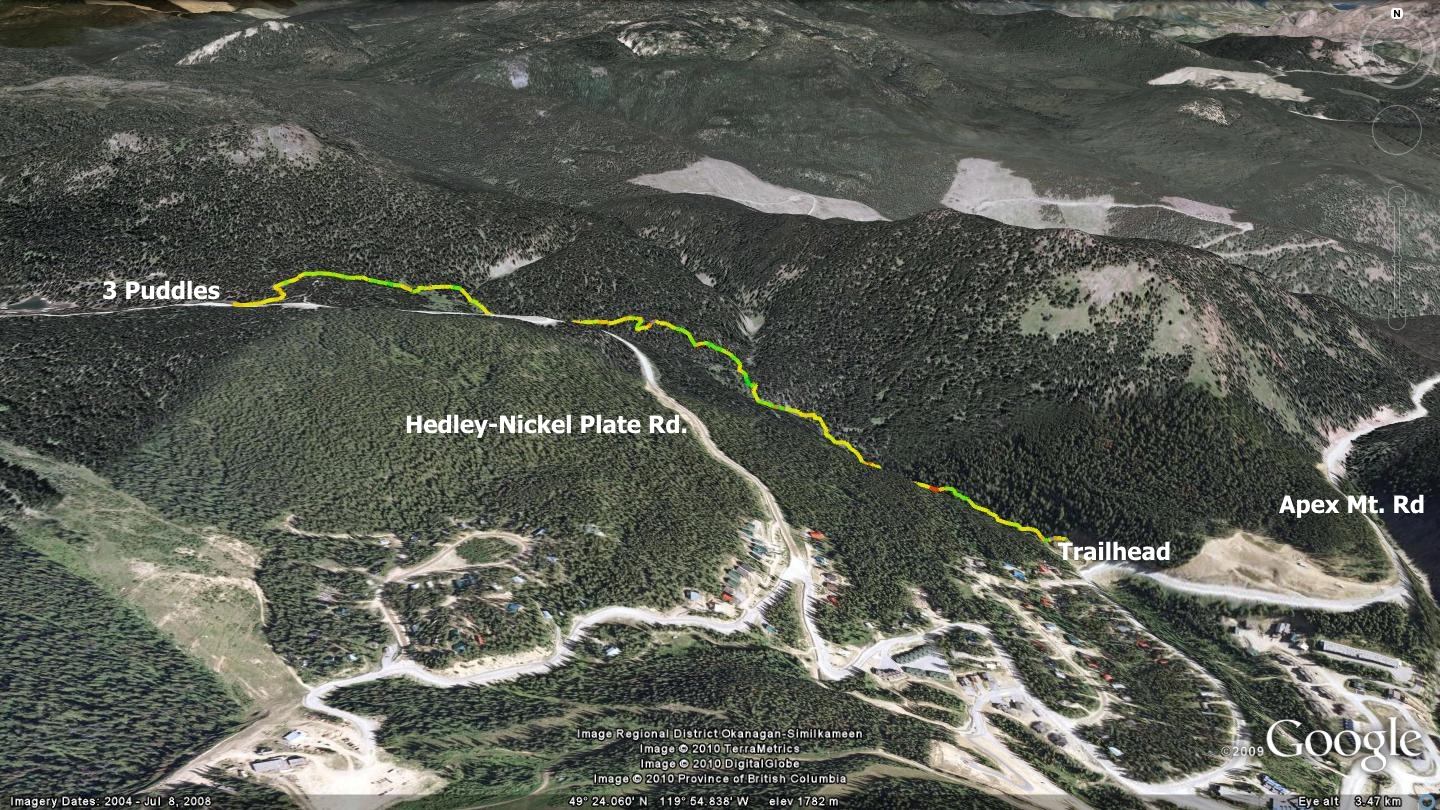
An amalgamation of the names of its three founders Johan, Dino and George, the Jodinge trail (pronounced Yo-Din-Jee) follows a valley which runs between the hairpin turn immediately prior to entering Apex Village, and the Hedley-Nickel Plate FSR (Forest Service Road) near Nickel Plate Lake. For the most part, Jodinge closely follows the upper Keremeos Creek drainage basin, eventually turning and ascending from the creek to meet the aforementioned FSR and a trio of small ponds locally known as the ‘Three Puddles’. Diminutive as they are, if you hike Jodinge on a torridly hot summer day, you will view these puddles as refreshing salvation!
Those with an exceptionally high degree of bike handling skills will find most of the Jodinge trail traversable on a mountain bike. If travelling by mountain bike, I suggest that you begin from the higher, well-flagged singletrack trailhead on the Three Puddles side. On the other hand, those hiking the Jodinge trail may wish to enter at its lowest point and navigate it as a mild ascent to the Three Puddles. Travelled in this manner, you experience a classic singletrack trail that generally follows the gently flowing upper Keremeos Creek. When I last traveled the route, there were very few trees down across the trail and it was well flagged and trimmed of branches.
I will first describe the route as accessed via Apex Mt. Rd., ascending to the Nickel Plate FSR. Make your way to the northern edge of Apex Village, to the hairpin turn just beyond the first homes as you enter the Village. Behind the concrete barriers lining the road lies a hidden gravel road leading down to a small, lower parking area. Use extreme caution as you enter or exit this narrow path as Apex Mt. Rd. is frequently driven aggressively by locals and tourists alike.
Park your vehicle in the lower lot and head toward the creek, staying on the same side as the main parking area. There you will locate a singletrack trail hugging the creek; welcome to the Jodinge trail. From this point on, a well trodden singletrack heads northwest along the creek.
During this adventure, you will eventually happen upon a wooden ‘bridge’ consisting of small diameter branches laid side by side, appearing on your left. Ignore it, as it leads back toward Apex Village and enters the property of a number of private residences. Continue northwest along the main path, diverting up the hillside to avoid downed trees when necessary.
Approximately 1.9 km into the trek, you will find yourself just shy of a steep valley with many loose boulders on its left flank; do not enter this valley. It is at this point that the trail takes a sudden turn toward the southwest (left).
Seek cairns or flagging tape and begin your ascent to the ‘puddles’ and the Hedley-Nickel-Plate FSR. You will soon enter a section where the ‘correct’ trail is not only vague, but also downright confusing as numerous other singletrack trails lead off in all directions. It appears that wildlife have been using this area as something of an intersection for many years.
Head up what appears to be an old, heavily overgrown road, keeping your eyes peeled for flagging tape in the trees, indicating the continuation of the Jodinge trail. At this point, you are ascending a shallow draw in the land, in somewhat of a clearing. The Jodinge trail soon becomes apparent again as the forest closes in and you continue to rise in the direction of the Hedley-Nickel Plate FSR.
Less than a kilometer later you connect with a well-trodden two-track roadway; a section of the Vista Loop cross-country ski trail system. Head to your right where you will quickly meet the Hedley-Nickel Plate FSR and the first of the ‘Three Puddles’. Should nature call, there is an outhouse 250 meters up the Hedley-Nickel Plate FSR, to the south. Though Jodinge is a brief trail, its ambience and aesthetics make it one of those ‘not to be missed’ trails in the Apex area.
If you are seeking to begin your exploration of the Jodinge trail from the three puddles side, make your way to the parking area across from the Hedley Nickel-Plate FSR. Begin heading down the FSR and continue along it for 95m. Ignore the road junctioning to your right; instead, head left (west) and travel 40m further along the main FSR. At that point, you will see another small road junctioning on your right. Take this right-junctioning road and continue along it for approximately 175m. There you will find flagging tape marking the Jodinge trailhead, which exits the road in your left.
Getting there If you are looking to explore this brief trail, you are likely already at Apex Resort. As such, I am not going to get too deep into details in this description. Leave Penticton and head up Green Mt. Rd. as far as the Apex Mt. Rd. turnoff. Ascend Apex Mt. Rd. as far as the final switchback trail just prior to entering Apex Resort. Look to your right along this switchback and you will see a row of concrete safety barriers; the Jodinge trailhead lies behind these barriers.