

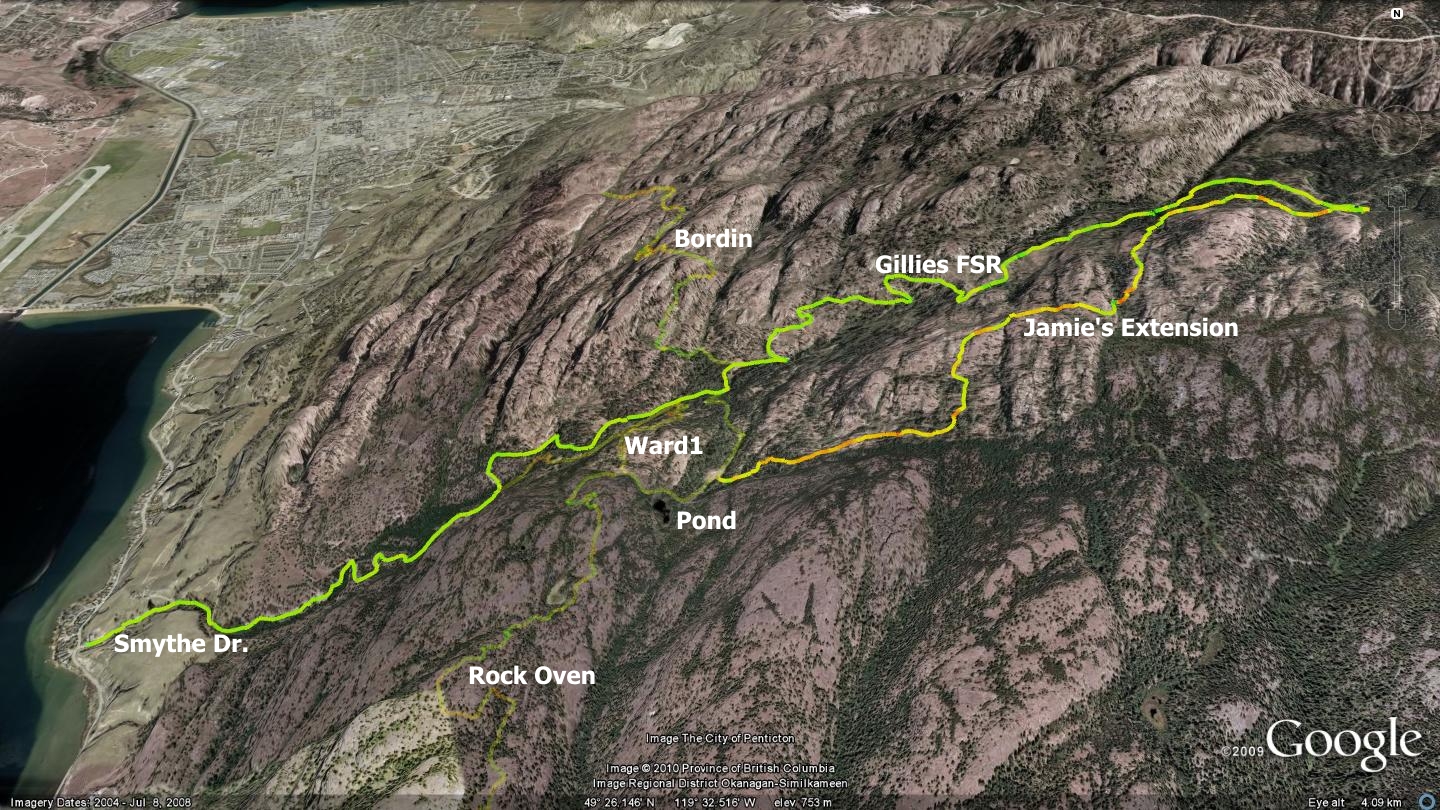
Jamie’s Extension adds distance, character and some might say “pain”, to an already excellent trail; the Rock Oven singletrack. Thanks to the work of Jamie J. and companions, the Rock Oven singletrack trail, described elsewhere in this publication, is extended by this climb up Smythe Dr. and Gillies Creek Forest Service Road (FSR). I generally refer to this trail as an extension of the Rock Oven singletrack, but in reality, it can add to numerous trails that exist in the general area.
While exploring this route, one ascends beyond the classic Rock Oven turnoff, continuing on dual-track road for an additional five kilometers before hooking up with a technical singletrack trailhead; this is where the fun begins!
The route is exemplified by a tough grunt up Gillies Cr. FSR, followed by a maniacal descent and an array of trail options to choose from for your finish. The map accompanying this chapter depicts Jamie’s Extension in the regular, bold color that I employ for other maps in this publication. The map also includes faint indications of the Rock Oven singletrack, the Bordin Trail and WARD1. I have included them to help you envision the many ways that other area trails can be combined with Jamie’s Extension.
Though rather protracted, the ascent is a great cardio workout and warm-up for what you will face when you connect with the singletrack at the apex of the climb. The two-track forest service road used for the ascent features a firm, easy to navigate surface, while the singletrack descent back down to a small pond, marking the entry of the Rock Oven singletrack trail, is quite technical.
As mentioned on several occasions in this publication, while you are recreating in the Smythe Dr. and Gillies Creek area, you are in fact a guest of numerous environmental conservation groups. Through a cooperative agreement with these government and non-government bodies, we are allowed to enjoy non-motorized recreation within this valley, so long as we do not exhibit any impact on the flora and fauna. Basically, be respectful and responsible while you are using this area and we will enjoy a long and joyful access to this unique zone.
The significant climb to the trailhead weeds out the less skillful recreationalists, so in essence, the route features a built in natural selection system. Upon reaching the pond at the bottom of the singletrack descent, often just out of view and oftentimes behind low bush, you have three options:
- Return to the base of Smythe Rd. or to the Skaha Bluffs parking area, by heading right. Within 800m, you will connect with the dual-track road you rode up on in the first place. Descend it and remember that Smythe Rd. is now a busy route due to the existence of the new Skaha Bluffs climbing area parking lot.
If you would like to experience a singletrack trail down to the parking area instead of the two-track, seek out the WARD1 trail described elsewhere in this publication. If you examine the map accompanying this chapter you will notice that WARD1 appears as a faded multi-color GPS track.
- Ascend the Rock Oven singletrack trail by locating and navigating counter-clockwise around the pond which you will see at the base of Jamie’s Extension. See the chapter detailing the Rock Oven singletrack trail elsewhere in this publication.
- Make your way to the Bordin singletrack trail. This will allow you to cross a dividing ridge between trails that are based out of Gillies Creek and a group of others that originate from the end of Evergreen Drive and wind their way through the Wiltse Highlands. The Bordin and Wiltse trails are described in detail elsewhere in this publication.
Remember that this publication’s companion website; sweetsingletrack.ca hosts freely available maps, as well as Google Earth and GPS files. These will be of assistance to new users to this area.
Getting There From the Peach in downtown Penticton, take Martin St., which changes into Main St. Travel this route to Kinney Ave, head left on Kinney to Main Street South. Follow Main Street South all the way out of town. Smythe Dr. will appear on your left near a blind corner. Travel up Smythe to the Skaha Bluffs parking area. This road is particularly busy and narrow, so use caution while navigating it.
Low: 350m | High: 1170m | Length: ±16km | Water: Not potable | Cell Access: Mostly