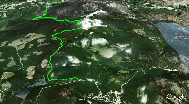
The Husky Trail is yet another route that I owe knowledge of to Peter Matthews and Jamie Johnson (the list is getting longer with these two). Click on the map above to see a larger version. you may also prefer the topographical edition found here.
On a hot August afternoon in 2011, Peter, Brent and I were dropped at this route's trailhead by Louise, with a plan at hand to ride north-northwest toward Isintok Lk. Peter and I had previously investigated the northern sections of this trail, but this was to be our first end-to-end exploration.
We sported the advantage of having Jamie Johnson's GPS track at hand, which was a great time-saver. I strongly recommend that those of you who tackle this adventure carry a GPS device and a backup (GPS trail drawn on a 50:1 paper map perhaps). As mountain bike ride, the trail should only be attempted from south to north; bike travel in the opposite direction would be absolutely grueling! Hikers may attempt it in either direction and equestrians likely need not apply due to a couple of extremely steep sections.
The route is comprised of forest service roads, quad trails and singletrack, with a bias toward quad trails. Should you choose to use the same drop site as we did, it has the benefit of a bullet hole riddled biffy - always a favorite after a long night and short sleep - and this one with enhanced ventilation!
Husky Trail is roughly 27km in length and might best be described as 'difficult'. Not because of the ascents / descents, but rather, due to it's inclusion of a variety of creek crossings and muddy zones as one nears the end of the trail. The overall theme is 'rugged'; folks who dig adventuresome rides will really love this trip.
There is a shipload of singletrack here, but also more quad trail than anything else on this site. This quad track is in quite good condition however, and more or less resembles 'dual singletrack trails'. I'd estimate that 98% of the Husky Trail is rideable.
I would suggest that it be attempted in late fall for best results; this will keep keep flying pests at bay and provide the most mud-free version of the route. Sections nearer the north end may even be slightly boggy all year around. I've seen the northern section in the spring and fall, and on both occasions the name of the game was 'moist'. The spring / summer of 2011 provided higher snow pack and more groundwater than any of the previous 10 years however, so its hard to say what the area 'normally' looks like.
Assuming that you begin where we did, drive to Apex Ski Resort, climbing Apex Mt. Rd. all the way through the village as though you were heading to the old top parking lot. When Apex Mt. Rd. makes a sharp, climbing left turn (to the top parking lot) ignore the turnoff and continue along the route straight ahead toward the Nickel Plate Lake Nordic Center / Hedley for a distance of perhaps 1.8km. The grouping of signs that you seek looks like this.
At this point you will find yourself at an intersection of sorts, with a road dropping down to your right (Hedley Creek / Nickel Plate Lake FSR) and a basic parking area on your left. A narrow two-track (Mt.Riordan Service Rd.) climbs into the forest from this parking area.
As few have trekked this route, I must strongly advise that you take a GPS device with you, along with the GPS file which is available on this website. Without these, you will likely become lost; there are just that many turnoffs and junctions in this trail. Ignore this warning at your own peril, as I am not going to elaborate on the route description; it would quickly deteriorate into a quagmire of "take this turn, ignore that turn" ad-nauseam.
I can only suggest that you bring extra water (in excess of two liters) more tire / chain / derailleur tools than you usually pack and perhaps an extra tire folded and bound to your frame. For back-country cycling adventures, I like to duct-tape a folded tire to the bike's handlebar stem; it provides peace of mind as well as an amazing nard-guard / chest protector :-)
Arrange to have someone pick you up at Isintok Lake, and be sure that they bring extra food / water for your arrival (watermelons are great!). The route will take advanced riders somewhere between three and four hours, depending on their riding skills and how easily they are distracted into investigating the (many) paths leading off the main route.
I'd suggest that you refrain from introducing beginner or intermediate riders to this trail, as there are just enough hike a bike / push bike sections that you will only dissuade then from pursuing future mountain biking adventures - or at the very least, any more with you!
Some of you may decide to camp at Isintok Lake, which sports a pretty cool little campground. If so, keep in mind that you are camping at elevation (1650m), so arrange to have warm cloths for the evening campfire and festivities
Operator or sponsor: BC Ministry of Tourism, Total free/unserviced campsites: 5, Tables provided at campsites, Pit toilets, Boat launch
Getting there: Drive up to Apex Ski Resort from Penticton via Green Mt. Rd., and follow the instructions above.
(Of the three cellular signal providers we tried, Telus seemed to offer the only reception, even then it was 'spotty')
