

Cow Highway Developed by wildlife & cattle, then introduced to me by local legend Howie Richardson (author of Skaha Rock-Climbs ISBN# 09682472-9-6) this excellent cross-country route rolls through nearly 20 kilometers of hillside above and just east of Vaseux Lake. Along the way, it provides numerous and impressive vantage points as well as immersion into the Okanagan‘s protected grasslands (BC Parks Grasslands Protected Area).
Howie was kind enough to show me the route early one morning in the summer of 08’. The trail is near and dear to him, thus it was with some trepidation about its future that he revealed its entrance and route. As such, I ask that anyone venturing out to enjoy its beauty please take extra care in navigating the trail. Treat it like it’s a gift from a good friend, to be cherished and respected - because that’s exactly what it is.
Folks on heavy downhill bikes will despise the route as there is a great deal of roller-coaster-like climbing and descending along its path. Don’t let the fact that we shuttled this ride allow you assume that it’s a ‘drop’. Even on a cross-country mountain bike, this trail can be a grunt.
Hikers will enjoy the Cow Highway as a foot route, albeit a slightly long one for beginners. While it could be navigated as a loop, most will choose to travel it via car-shuttle due to the 8K gravel-road trek required to reach the trailhead. In our case, we chose to drop a vehicle at the exit of the route, continuing up in a second vehicle to the starting point.
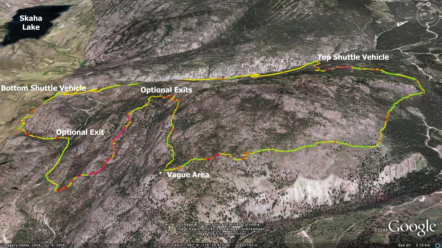
This trail sports many obscure intersections early on. As such this is one of the few trails in this publication which demands that you use a GPS device to ‘find’ the trail the first time through. Download the free universal file format GPS track which I have made available on the companion website (sweetsingletrack.ca). Install it on a GPS unit or smartphone and you are ‘good to go’.
This route isn’t for those disenchanted with adventurous trail-finding. Although the initial two-track route to the trailhead offers an easy warm-up on gently climbing, overgrown two-track, you will soon be facing a plethora of exits to various single & dual-track routes. The area has been subject to a great deal of ranching and exploration over the past century and this is reflected in the area’s wide variety of semi-overgrown access routes. There are so many junctioning tracks and trails along the way, that it would be nearly impossible for me to accurately describe the route without creating a situation where readers mistook what I saw as a “not worth mentioning”, for what they viewed as a legitimate path.
Using the GPS track described above, you will find the correct entrance and arrive at a fence across your route and a wooden loading ramp to your right. Cross the fence and be sure to leave it in whatever state you found it. Beyond the fence you will find that the road surface deteriorates and soon dissolves into a singletrack trail bearing right.
You soon find yourself passing through beautiful grasslands and forests with amazing views. At one point the trail seems to dissolve altogether. A scramble ensues and you find yourself heading west, over and down gentle chutes in a cliff band. Scrutinize the online maps to determine the exact location - I have marked it ‘indistinct’ on the GPS file. Terrain becomes quite rocky and technical beyond approximately three-quarters of the trail’s overall length. There, the track will be above the skill level of all but the most advanced cyclists. Hikers will be in their glory. When in doubt, remember that there is always the ‘just walk it’ option.
Use caution and note the three optional exits along the way (see the accompanying map and detailed files online at sweetsingletrack.ca). These exits will drop you back to the road which you used to access the top trailhead, allowing you to descend safely to the bottom vehicle on the gravel - assuming you conducted the loop as a shuttle. The last time that I was through the ‘easy-outs’ they sported numerous downed trees, so should only be used as a route of last resort.
Those who stick with the Cow Highway until the end will be rewarded with some of the most amazing singletrack in this area of the Okanagan. Near the bottom, you will find yourself gliding across the two-track known as ‘Shady Lane’ - grinning ear to ear and looking forward to your next trail exploration. This area is part of a wildlife conservation project and our presence here is officially ‘tolerated’ as long we do not make any major impact on the land. Be cool.
Getting there Depart the Peach in Penticton and drive south on Winnipeg St. to Fairview road. Continue south on Fairview until you reach the Channel Parkway (aka; Highway 97). Head south on 97’ to Okanagan Falls. Pass through OK Falls and hang a left on Weyerhaeuser road. Drive 920 meters to the point at which it intersects and crosses with Maple St. Set your odometer here as the parking area for the lower shuttle vehicle is approximately 3.6 kilometers beyond this point up Weyerhaeuser road. Once there, switch to the top shuttle vehicle and drive eight kilometers further up Wayerhauser Rd., where you will park and begin the dual-track section of the trail.
Low: 519m | High: 1263m | Length: 19.3k one way | Water: none | Cell Access: Most areas