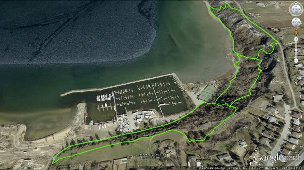
The name of Penticton’s ‘Hobo Jungle’ comes from its popularity with transients seeking cost-free camping; although it's illegal in this particular area, and those attempting it risk a curt visit from the local constabulary.
The Hobo Jungle is a fun, albeit small, mountain biking and hiking area within city limits. It features a plethora of trails that wind up, down and along the clay banks northeast of the Okanagan Lake marina. These trails appear in two forms; a legitimate city designated path known as the Esplanade Trail and a group of random routes; colloquially known as ‘social trails’, which crisscross the clay banks above it. This chapter addresses both options.
Though there are three main entrances into the Hobo Jungle’s social trail network, the one shown on the map above suggests a route offering the longest travel as well as the best views.
The city parks board prefers that recreationalists enter the Hobo Jungle via their Esplanade Trail Network. This trailhead is accessed by making your way to the tennis courts located at the end of Marina Way. There, a well-signed trail enters the forest to the right of the tennis court parking lot and gently meanders along Okanagan Lake’s shore. It dead-ends less than a kilometer in, at the former location of a large pier - long since removed. This entry and accompanying trail represents the easiest introduction to the area.
On the other hand, the social trail network which I will describe below allows one to experience the wild and winding ‘off the record’ singletrack trails which exists along the clay banks, far above the Esplanade Trail. Please be aware that this area is not for beginners - due to its steep and oftentimes dangerous side-hill trail construction as well as its aggressive pitches and rolls.
In order to access the trailhead, follow Marina Way until you arrive at 250 Marina Way; a gargantuan structure with numerous statues and fountains decorating its premises. This building also houses my favorite coffee shop; Bean On The Beach; which you really should check out!
This large structure encompasses the entire hillside between Vancouver St. above and Marina Way below, so one really cannot miss it. Note that the map accompanying this chapter is tilted on-edge - north to the left.
Immediately east of this massive building is Abbot St. Turn right off Marina Way and head up Abbot St. approximately 20 meters, at which point you will see an obvious trail leading off to the left and up.
A short climb up this trail will put you onto a field from which you can enjoy impressive views of the marina, Okanagan Lake, and beyond. Continue along the edge of the field some 270m, at which point the trail plunges steeply straight ahead into the forest; ignore it. Instead, turn right and travel 30m, at which point you face a plunging trail lined with sagebrush.
Dive right in and enjoy the gravity buzz, but be aware that at the bottom, the trail snaps hard to the left and begins to climb steeply to a ridgeline above the clay banks, reaching the highest point of the trail. Though you may be tempted to stay high along the bank, continuing along the uppermost edge is not permissible, as property owners have blocked the route for reasons of privacy and liability.
If you happen upon the No Trespassing signs, simply backtrack a few meters and you will see an obvious path dropping down into a forest of Russian olive trees and the main body of the Hobo Jungle. Speaking of Russian olive trees, the area is overrun with them and their spiky branches.
Once within the forest, stay on the area’s higher trails in order to avoid quickly losing the available vertical. Ignore for now the many crisscrossing trails, most short and steep, which drop off to your left; they are worth exploring later, but will find you back at the pavement below in short order.
You will eventually enter a clearing and face an incredibly steep up-slope to your right. This trail ascends to a lookout point and connects with the Kettle Valley Railway. As much as it is a tough slog to attain this elevation, it is worth the climb to view several interesting historical railroad artifacts and read the set of plaques mounted there.
Climbing up to this point also affords you the access to the KVR, which leads to a wide variety of destinations, including the popular Three Blind Mice trail network described elsewhere in this publication. If on the other hand, you wish to avoid the ascent and KVR, drop down and wind your way onto the various paths near Okanagan’s lakeshore.
Heading too far north will find you at a dead-end, as the clay banks beyond are too steep to support trails. Explore the area, and then head back along the mellow but impressive Promenade Trail. You might also wish to enjoy some of the cheapest beer in town at the Yacht Club, located adjacent to the tennis courts.
Getting there: From the Peach by Lake Okanagan in downtown Penticton, travel along Lakeshore Drive until you reach Front St. Hang a left on Front St. and cross the bridge. Enter the traffic circle, and turn left onto Marina Way.
Low: 342m | High: 395m | Length: Varies | Water: None | Cell Access: Full
.
