

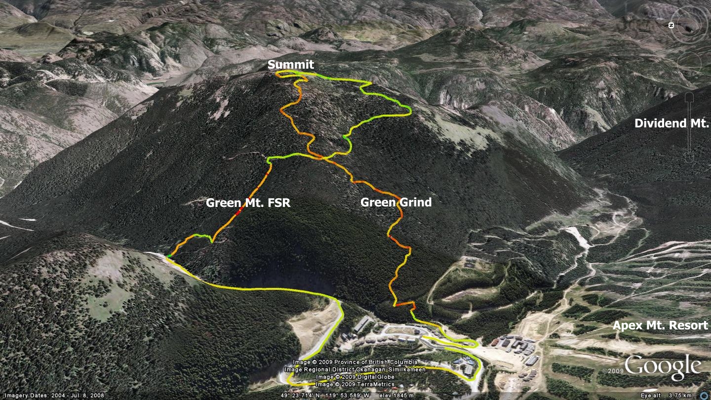
Green Mountain, located across the valley from Apex Ski Resort and village, offers several access routes to its summit, two of which I describe here. These are presented in the accompanying image, crossing each other in a figure-eight pattern. One is a steep forest service road (FSR) which begins at the final cattle-guard on the way up Apex Mt. Rd., prior to Apex village. The other is an enjoyable section of singletrack known locally as the Green Grind.
While dual-track roads tend to be an easier way up significant ascents when compared to singletrack climbs on similar slopes, in this case it proves to be every bit as difficult. The Green Mt. FSR surface is strewn with small boulders of all shape and size and is relentlessly steep. If hiking or snow-shoeing, either route is a good workout. Cyclists will frequently need to push their bikes either way.
If cycling the two-track road up, begin your journey at Apex village. The distance quoted in this chapter assumes a FSR access and singletrack trail egress. Take advantage of the brief warm-up provided by the paved road between the resort's main (lower) parking area and trailhead, a distance of perhaps 2.4 kilometers. The first of many imposing pitches begins immediately upon reaching the Green Mt. FSR trailhead (cattleguard). I have snow-shoed, hiked and cycled the route; all three are challenging!
What lies ahead is 3.5km of aggressive climbing to the summit. Along the way are cattle-trails which crisscross the main route, many of which invite future investigation. A dirt bike excursion via an old mining road on Green Mt.’s backside demonstrates that at least one other route exists to the summit of Green Mt. (Klohtelt Creek - see the Keremeos Creek chapter)
As you near the summit, the terrain flattens and the FSR improves significantly. I suggest that you visit mid-summer, when the mountains are carpeted in flowers. The incredibly strong scent emanating from the vast expanse of wildflowers will leave a lasting impression. Stunning vantages greet you from the large, relatively flat summit, inviting casual exploration.
Take some time to circumnavigate it, checking out the vistas which unfold in every direction. The singletrack trailhead for the downward journey isn’t immediately obvious, so study the maps here and online for hints to its whereabouts. Downloading and installing the GPS track for this route on a hand-held GSP or smartphone greatly assist in locating it.
You may optionally wish to ascend Green Mt. via the singletrack. It can be accessed from a vague trail located directly opposite of the lower / overflow parking lot behind theSaddleback Lodge
Said parking area is visually located in the centre of this map-link. The singletrack trailhead is located across the FSR / directly north and a little to the right of this parking are,
The 2.7-kilometer Green Grind singletrack trail is every bit as steep as the two-track FSR. You will find yourself pushing your bike in many spots should you choose to attempt a ride to the summit. 'Walk-Mode' on an eBike is mandatory... Hiking and snowshoe access is challenging but enjoyable for those in good physical shape. Along the way you will happen upon the dual-track road described earlier – cross it and continue up.
Despite the aggressive ascent up either route, the singletrack descent via mountain bike is absolutely first class - with the exception of a major 'V-out' near the bottom. Check your speed in order to avoid hard braking, which inevitably leads to skidding and unnecessary erosion. There are three sections that absolutely need switchbacks added; locals builder / maintainers please take note...
Please pitch in with maintenance as every little bit helps. Note that the accompanying image is set on edge, with north to the left of the map.
Getting there; Start from the Peach, downtown Penticton; drive south on Winnipeg St. until it intersects with Fairview Rd. Stay on Fairview to the major intersection with the Channel Parkway (Hwy 97). Cross the highway into the Penticton Indian Reserve and onto Green Mt. Rd. Follow Green Mt. Rd. to the intersection with Apex Mt. Rd. Follow Apex Mt. Road to Apex village.
Low: 1722m | High: 2108m | Length: 6.5k return | Water: none | Cell Access: Total