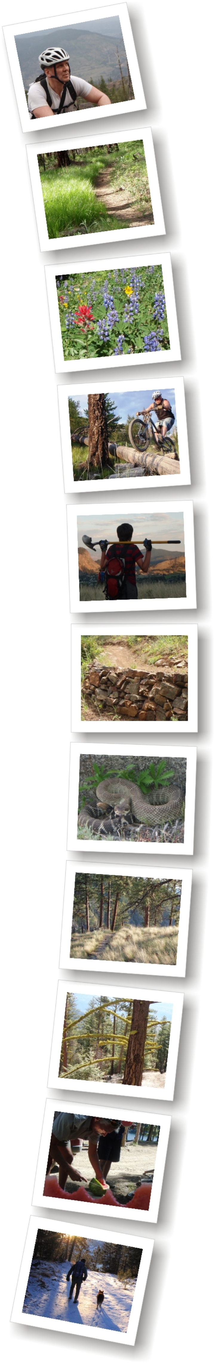
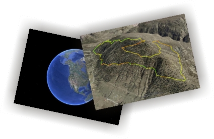
The following links are to digital files representative of each of the trails described in the 'Read Chapters Online' link on the main page.  They are recorded in a file format that is only readable by the free Google Earth software application.  Feel free to sample as many as you like, but I ask that you do not repost them to any commercial sites such as 'everytrail.com' etc.

Web browsers differ in how they handle these files; Internet Explorer flat-out makes a mess of them, while Google Chrome appears to be the best of the lot; (including Firefox & Safari).

With Internet Explorer, one has to first download, and then 'unzip' the file; a technical hurdle for most computer users.  I suggest that you download and install the free Google Chrome web browser and use it for the task.

With Chrome, one simply left-clicks and releases on any link below, waits while the file downloads, then clicks on the file which soon appears at the bottom left-hand side of the web browser's screen.  Google Chrome fetches Google Earth and viola!, a fantastic 3D representation of the trail appears!


Angel Springs / KLO Trail

Apex Bowls & Orange Trail

Apex Ski Resort (summer)

Apex Resort Fat-Bike Loop

Apex Winter Trails

Arawana Beer Run

Balsam Route

Baldy Mountain Resort

Bear Creek

Bedford Trail Network

Bordin Trail & WARD1

Brent Mt.

Campbell Mt. Switchback

Campbell Mt. Classic

Campbell Mt. - Full Data Set

Carmi Recreational Trails

Cartwright Mt. - Three Loops

China Ridge - Princeton Rail Trail

City of Penticton - Surfaced Routes

Climax

Code 4 & Knuckle-Duster

Crawford (Myra-Bellevue Prov. Park)

Crow Pass

Damage Case

Davidson Creek Trail (aka: Carrot Mt. Trail)

Derenzy Lake Loop

Ellis Creek Canyon Trails

Ellis Creek Reservoir

Fur Brigade Trail (Summerland to Peachland)

G-Spot

G to the T and Rustler

Giant's Head Mt.

Gladstone Trail

Glen Canyon (Lower)

Glen Canyon (Upper)

Goats Peak Regional Park

Green Mt.

Guy's Cache

Hidden Canyon Falls

Hobo Jungle

Howie's Cow Highway

Husky Trail

Jamie's Extension

Jodinge Trail

Kalamoir Regional Park

Kelowna Nordic XC-Ski Trails

Kelowna Nordic Snowshoe Trails

Keremeos Creek FSRS

Knox Mountain

Kraut

Lacoma Lake (Trepanier Protected Area)

Little White Mt.

Lookout Mt.

McDougall Rim ("Bylands Loop)

Manitou Park Track

MacIntyre Bluff

Mahoney - White Lake Loop

McKinney Nordic XC-Ski / Snowshoe Trails

Midway Trail Network

Mill Creek Regional Park

Mission Park Greenway

Morel Loop

Mount Boucherie

Mount Brent

Mount Conkle

Mount Eneas

Mount Hawthorne

Mount Keogan (G.E.O.M, Dogtown & L.J Trails)

Mount Kobau

Mount Laidlaw

Mount McLellaN

Mt.Riordan (Apex)

Nickel Plate Lake & Apex Lowlands

Ocher & Eagle Bluffs

Okanagan Mt. Park - South Okanagan Mt. Park Loop

Oliver Hike & Bike Path

Palmer's Cow-Trail

Pancho's Revenge

Peach Cliff / Goldfish Pond / Fire Mt.

Pincushion Mt. - Trepanier Trails

Powers Creek Trail Network

Rail Beds - Local Sections

Rattlesnake Lake

Rattlesnake Mt.

Ridgedale Ave.

Revelstoke - Frisbee Ridge + Keystone Standard Basin - Road Trip!

Rock Oven

Rose Valley

Sage & Sparrow Protected Area

Sheeprock Mt.

Silver Buck (incl. G-Spot up)

Skaha Bluff

Smith Creek

Spion Kop

Summerland Centennial Trail

Telemark Nordic Club

Test of Humanity Race Course

Three Blind Mice

Trout Creek Stroll

Vaseux Lake Wildlife Centre (boardwalk and lookout tower)

West Apex Trail Network

White Lake Lookoff trail

Wilson Lakes

Wiltse Highlands Trail

Woodwacker's Trail

Wright's Passage

Yellow Lake Trail


Click to enlarge