

The Ellis Creek Reservoir features an interesting bit of history, one that is irrevocably tied to the history of Penticton. In the middle of the night on May 19th, 1941, after a hot day succeeded by a heavy rain, a rush of water and what seemed the peak of the flood came down both Penticton and Ellis creeks. This initial rise in the creeks was however, only the result of the high mountain watersheds channeling their bounty of rainfall.
Later that evening, Penticton’s new Ellis Creek Dam #3 (Dufresne dam) broke high above the town. The Dufresne dam failure poured approximately 370,050 m3 of water over the land. The failure was caused by floating anchor ice, which carried back fill and tamped earth to the surface with it. The 82.5m long dam structure was only about one year old and had a cement core 13.2m wide and 6m deep in the centre.
The following morning Ellis Creek overflowed the channel banks in many places. Floodwaters covered Main St. for nearly a kilometer as the now wild Ellis Creek flowed down to the Channel parkway in half a dozen different paths. Noon on the 20th found the floodwaters threatening the bridge on Main St.
It was hard to keep Ellis Creek confined to any particular route as it relocated its many historical means of reaching the channel. Debris and rocks continually formed dams, throwing the creek into new courses and causing more damage. The creek uprooted many trees, including a pine over a meter in diameter. May 21st found Ellis Creek higher than ever in the history of the municipality, and despite efforts made during the previous two weeks to provide protection against high water, the flood rush swept across roadways, through orchards and open spaces.
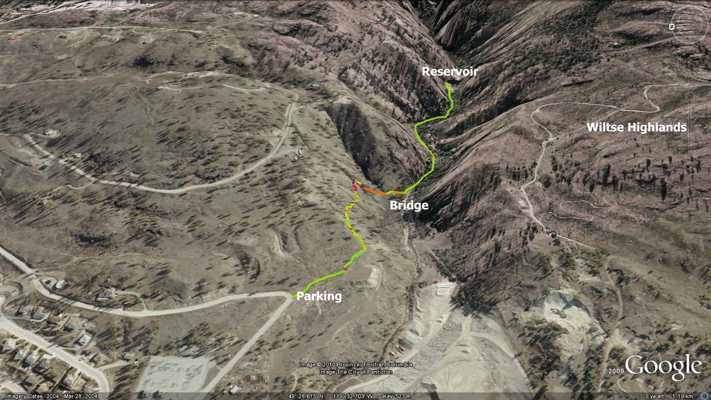
What does any of this have to do with trails? Thanks to the kindness of one private landowner, we enjoy legal access to this same valley bottom via a steep, rocky singletrack trail on Penticton’s east side. The trail presented in the accompanying image traces a path along a precipitous side-slope, down a steep spine of land and into the valley floor where Ellis Creek innocuously meanders out of the canyon and into the city.
There are several methods of accessing the area, but the one presented in this chapter offers the only route that I know of that does not involve trespassing issues. I have spoken with the landowner and received his blessing on the trail; please repay his generosity by being very careful while crossing his land and respect the area by keeping it clear of litter. The route features several [extremely] difficult to navigate sections just beyond its trailhead; take this as fair warning!
The Ellis Creek Reservoir trail begins at the first sharp left hand corner atop Carmi Ave. There exists a small parking area overlooking the peat bog storage facility at the trailhead. Proceed approximately 200m to the canyon edge where you will notice a narrow singletrack trail heading east across the steep, rocky embankment.
This steeply pitched slope represents the private land mentioned earlier. This area is also the reason for the black-diamond rating; it is potentially deadly to those lacking experience, endurance and proper hiking gear. This aggressively side sloped and rocky trail carries on for approximately 275 meters before meeting a steep ridgeline that drops to the valley. Here the trail changes direction and begins descending along a footpath toward Ellis Creek.
People and wildlife have frequented this path to the point that it is more or less established and occasionally marked by rock cairns. Descend to the valley floor and your ultimate destination; a two-track trail leading to the city’s agricultural intake reservoir. Your return trip mirrors the descent, and is a challenging route due to the significant ascending required.
This is among the city’s closest hikes and is somewhat of a dichotomy, as it offers a potentially dangerous access route, together with some of the mellowest two-track trail around. Once you arrive in the valley floor, the hiking is quite literally no more difficult than a stroll in the park. The two-track road adjacent to the creek runs slightly under a kilometer before it meets the water reservoir. This is not the dam described in the story above, it is only a short term storage facility.
You will marvel at the incredibly steep and visually striking canyon walls and the beauty of the meandering creek that runs nearby for most of the lowland portion of the hike. The area is especially beautiful in the fall, when the deciduous trees shake off their cornucopia of color. I was unable to locate trails beyond the dam, and I would be surprised to learn that any existed due to the incredibly steep canyon walls beyond it. Note that the accompanying map is tilted to the left.
Getting there From the Peach in Penticton, head south on Martin St. It morphs into Main St. and caries on to a point where Carmi Ave. junctions with it on the left. Travel Carmi Ave. east out of Penticton as far as the first major left hand turn; this is the trailhead. Use caution in parking as Carmi Ave. tends to be driven above the speed limit.
Low: 515m | High: 533m | Length: 3.2km Return | Water: Not potable | Cell Access: Most areas