

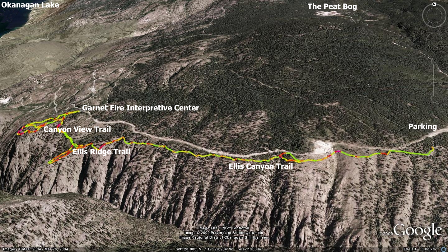
Ellis Creek Canyon, whose waterway is named after Tom Ellis, the first white settler, postmaster and cattle-baron in Penticton, offers numerous interesting recreational trail areas to explore, including several which appear elsewhere in this book. The trails described in this chapter were constructed by various groups including those under the supervision of what was then known as Canada Manpower, along with help from local forest fire-fighters. This particular trail network consists of three components: a pair of loops to the edge of a steep, scenic canyon and a linear trail which shadows the Beaverdell Rd.
The images included with this chapter, including the 'click to enlarge' image above, provide an excellent overview of the area - however, if you wish to see an inset of just the two canyon loops, click here.
This main trail connects not only the aforementioned trail loops, but also upper and lower parking areas along the road and trail. The lower of the two parking area is titled ‘Garnet Fire Interpretive Site’ and is located directly across from the Lost Moose Lodge driveway. The upper parking area is located approximately 3.5 kilometers further east on the Beaverdell road and marks the entrance to the Carmi Recreational Trail system - which is described elsewhere in this publication. The linear trail connecting the two parking areas doesn’t appear to have an official title, so I’ve chosen to describe it as the Ellis Canyon Trail.
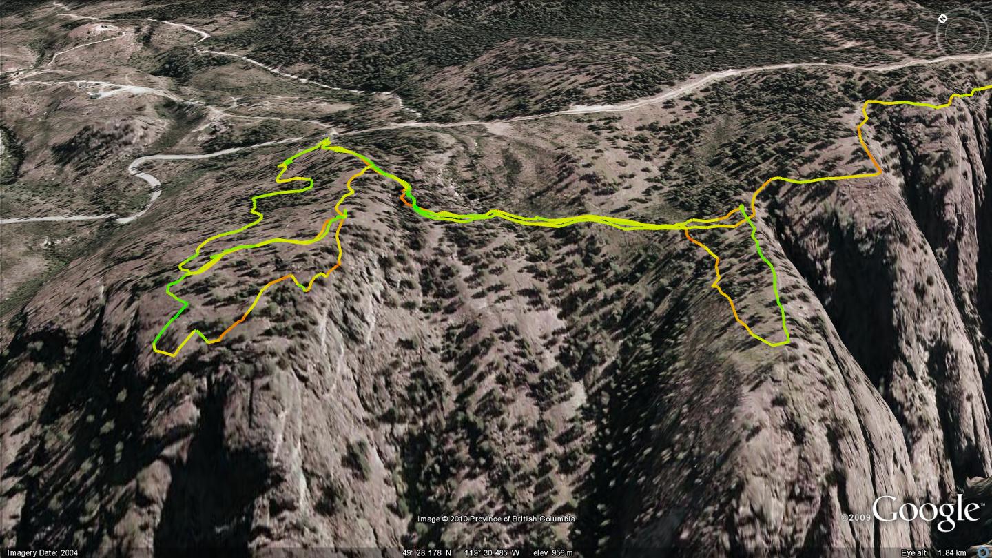
Canyon View Trail is a 2.2km long looping trail which begins at the Garnet Fire Interpretive Site and navigates a section of Ellis Creek Canyon in a perfect loop back to your starting point. Notice in the accompanying map that there are several trails within this loop; an unauthorized loop trail that departs the parking lot and heads for the unprotected cliffs strait ahead, as well as the actual trail which also heads in the same direction, but takes a right turn just shy of the edge (marked with a small rock-pile).
The unauthorized route peters out in a boulder-strewn field and leaves you wandering aimlessly, while the actual route continues in a loop back to the parking lot, popping out behind the info-kiosks you may have stopped at when you started your journey. Speaking of which, take a moment to read the information provided on the kiosk as you will learn a great deal about the area from it. A little more than three-quarters of the way through the Canyon View Trail loop you’ll happen upon a trail which crosses at right-angle to your path. Unfortunately, this unmarked downhill route to the valley soon begins to cross private property and is thus excluded from this publication.
Ellis Ridge Trail can be navigated by heading south, south-east from the Garnet Fire Interpretive Site as if you were heading out to navigate the Canyon View Trail described above. Instead of carrying on toward the edge of the canyon however, take a left turn at the Ellis Ridge Trail sign. This will find you on the Ellis Canyon Trail which connects the upper and lower parking areas as well as the two looping trails.
Make your way through the wooden man-gate, over the rambling rocks in the trail and you’ll soon see the Ellis Ridge Trail singletrack junction. The first of two entrances to the Ellis Ridge trailhead exists as a descending singletrack trail which appears on your right hand side some 500 meters along the Ellis Canyon Trail. It drops smoothly to the edge of a peninsula of land 300 meters to the southwest. At this point you’ll be greeted by a hefty picnic table and just beyond it, absolutely stunning views. This is a great place to rest and relax before carrying on.
If you are keen to experience the balance of the Ellis Canyon Trail, return to it via the route you arrived on the other ‘arm’ of the looping Ellis Ridge trail. Both obviously reconnect with the Ellis Canyon Trail, but the one you dropped in on is slightly easier to ascend. Continue 3k south-east on your way to the top parking area and Carmi Recreational Trail system trailhead.
You will climb moderately for the next 230 vertical meters, punctuated by several steep, albeit brief ascents on its way to connect with the aforementioned top parking area.
The Ellis Canyon Trail is in great condition and includes settings such as the cover photo of this book. For hikers the trail is a breeze either way. Mountain bike riders however need be hardy and open to a couple of push-bike sections if climbing up from the lower parking lot. You might also consider a car-shuttle or pedal up the gravel road to the top and enter there for a flowing downhill. Either way, this trail isn’t for the faint of heart as it offers a great deal of exposure to vertical side hill and oftentimes sports downed trees across the path.
Getting there From the Peach in downtown Penticton, drive up Winnipeg St. to Fairview, stay on Fairview to Duncan Ave. W. Hang a left on Duncan Ave. W. to Main St. and turn right on Main St. Drive one block & turn left on Carmi Ave. Drive Carmi to the parking lot across from the Lost Moose Lodge.
Low: 1027m | High: 1235m | Length: 11k return (varies) | Water: none | Cell Access: Full