

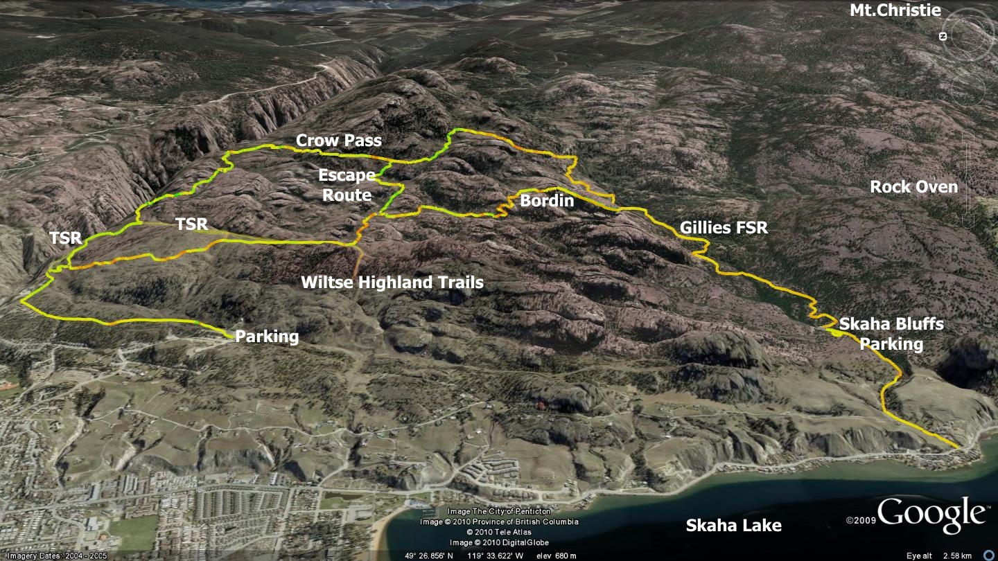
The Crow Pass trail is located high on the rocky eastern slopes overlooking Penticton. Access begins on the city’s eastern outskirts at the end of Evergreen Dr. The route follows a roughly oval loop as it runs first north, then east up the mountainside, south along a rough notch in the land, and north again, returning one to their starting point. I both have hiked and cycled this route; it presents an excellent, if slightly longish hike and a moderately brutal bike ride. The route includes a midpoint escape route for those who find the going too tough.
There are many trails and methods of accessing the area; Crow Pass is but one example of a convenient route that loops back to its point of origin. Other sections of this southwestern flank of Mt.Christie are detailed elsewhere in this publication. See the Wiltse Highland, Rock Oven, Bordin Trail and WARD1 chapters for additional adventures in the vicinity.
Mount Christie (named after Okanagan pioneer J.R. Christie) encompasses terrain between Shuttleworth Creek in the south, to Ellis Creek in the north; Skaha Lake in the west and Okanagan Falls forest service road in the east. The Mt.Christie routes presented in this book represent less than ten percent of the single and dual-track trails available on-mountain.
Many of Mt.Christie’s trails are in need of minor clearing and maintenance, but overall the surface material is quite rocky, thus capable of supporting trail use without erosion. The fact that this area is so close to town leads me to believe that trail user groups should expend some effort in maintaining and improving the existing legacy trail network.
There are areas of the mountain that must be avoided during the spring due to bighorn sheep calving, they include canyon edges and very steep side slopes. Also be aware that the lowest reaches of this route cross private property owned by the Wiltse family. They have posted signage that indicates a tolerance of non-motorized trail use. Keep the Wiltse Highlands / Crow Pass areas clear of litter and be respectful to the residents on Evergreen Dr. This will go a long way toward keeping relations between trail users, landowners and local residents on good terms.
The entrance to the Crow Pass trail lays hidden high along the mountainside, and while it is accessible from many directions, in this chapter I describe it as accessed via the Wiltse Highlands mountain biking route.
Park at the southernmost end of Evergreen Dr., indicated as Crow Pl. on the latest Penticton city map - although circa 2010, only an empty field exists there. Enter the field and head north. You will soon see a several meter wide footpath entering the forest.
As you travel this path, you will notice many singletrack and quad-trails crisscrossing it. Stay on the main trail until it forks into two, this split occurs at an area where the hydro line is overhead. Both routes eventually arrive at the same terminus - the Terasen service road (TSR). You will eventually ascend this TSR a short distance in order to locate the Crow Pass trailhead.
The right hand path under the power lines junctions with the TSR higher along its route, thus avoiding several hundred meters of steep and loose TSR roadway. The tradeoff is that the left hand path offers more shade in the heat of summer.
Travel either route north until you ‘T’ into the aforementioned TSR, if you become confused by the many trails in the area, simply follow under the power lines as closely as possible, this will inevitably lead you to the TSR. Ascend this gravel service road, watching for a well-worn singletrack that exits the road on your right, switching back and ascending to the south.
This singletrack trail weaves back and forth several times before junctioning with another singletrack that runs horizontally across the mountain. A right turn here leads to the Wiltse Highland trails, while a left turn heads for Crow Pass. You will eventually return to this singletrack intersection near the end of your loop, approaching it from the south. In order to follow the Crow Pass trail, head left (north). 250m along, you will again intersect with the TSR.
You ascended this same TSR prior to that short stint of singletrack. You could have stayed on the road to gain the vertical, but singletrack is always more enjoyable than roads! Ascend the TSR for another kilometer, at which point you will find that it levels out and becomes a strait roadway running north to south. The Crow Pass trailhead exits this road on your left; the body of the trail should be obvious as it crosses a grassy field, making for the forest to the northeast. You may have to hunt around for this singletrack when the grass is long in midsummer.
The Crow Pass singletrack leads several hundred meters into the forest, running across generally level terrain as it shadows the Ellis Cr. Canyon. What initially appears to be an easy to navigate trail soon begins to develop into a much more aggressive series of climbs and plateaus. Dirt bikers may have originally developed this route; thus explaining the testosterone induced pitches that you will soon encounter.
The area that this trail soon enters has been designated a Vehicle Restricted Zone by the provincial government. This stipulation relates to the region’s significance as a sheep lambing enclave. Coupled with the ban on motorized vehicles crossing the Wiltse lands below, I believe that we will see less dirt bikes and quads here in the future.
Vigorous climbing, or hike-a-bike if you ride this trail, followed by brief respites, continues for nearly a kilometer; thereafter gradients begin to mellow and the singletrack takes on a more enjoyable nature.
Approximately 5km from the trailhead, you will arrive at an obvious junction in the road. Here a right hand trail descends steeply to the west; returning to the Terasen service road and a small, oftentimes dried up body of water known as Lays Pond. This trail represents an escape route of sorts, as immediately beyond this point the trail begins to ascend more aggressively than at any previous point. It does so along a loose, rocky two-track trail for a distance of nearly a kilometer.
If you decide to descend the escape route option, be aware that the trail is quite steep and bikers will likely have to walk sections. The escape route trail places you back on the TSR, approximately 1.6km south of the point at which you met the Crow Pass trailhead and exited the service road. Those who familiarize themselves with the Wiltse Highland Trails (see chapter in this publication) will notice that they have numerous alternate routes to choose from in order to return to their vehicle or further explore the area. In this case, I will direct you up and over a ridgeline to the west, dropping you back to a singletrack junction that you visited earlier.
After dropping along the escape route and meeting the TSR, head right (north). 300m along this narrow service road, you will see a trail exiting and ascending on your left. Climb this trail for 500m, at which point you will have a commanding view of the city below. Continue over and down the west face of this height of land, descending the narrow pathway.
Stick to this main route for 1.3km, at which point you will find yourself at the same three-way singletrack intersection that you passed bye during your ascent. Hang a left and continue to descend, following under the power lines in order to return to your vehicle.
Those who choose to forego the optional escape route trail, continuing instead along the balance of the Crow Pass, are in for some steep ascents. A small swamp exists just south of the escape route trailhead, and during the spring or particularly moist summers, it can pose a challenge to bypass. Those willing to put their mettle to the test can savor the fact that the swamp is small, the brutal steeps are brief, and you will soon arrive at the route’s highest point of 1025m. There you are welcomed by outstanding views of the valley and a sense of satisfaction that can only be gained by pushing oneself to the limit.
A measure of rest and relaxation later and you are ready to see why I enjoyed riding this admittedly tough route; the descent and optional connection with the Smythe Rd. / Gillies Cr. trails alluded to earlier in this chapter. Upon descending from the summit, the Crow Pass singletrack turns into dual-track and soon merges with the Gillies Creek FSR. Turn right at this junction and descend the FSR.
Upon meeting with the Gillies Cr. FSR, set your odometer. The entrance to the Bordin trailhead is located 1.5km down this FSR. It appears as a singletrack trail that crosses the FSR in an open, generally level field; go right onto the singletrack at this crossing point. This trail is actually a short connector; the ‘trailhead proper’ is located 350m to the northwest along it. There you will see what appears to be a quad-trail rising steeply on your right; this is the Bordin trailhead. You may notice a trail that continues southwest beyond this three-way junction, this decommissioned route remains closed due to erosion and creek crossing issues; please avoid using it.
Much of the Gillies valley is owned and managed by a consortium of environmental organizations, in conjunction with BC Parks. This group have generously agreed to allow recreationalists access to several trails that were created ‘under the radar’ by locals. Considering that conservation, not recreation, is this environmental groups mandate; we must work to strengthen this agreement by respecting the few trails that they wish to decommission.
Crow Pass follows the Bordin trail (described elsewhere in this publication) back to your parking spot on Evergreen Dr. Once you have entered the Gillies Cr. valley, the geographical lay of the land dictates that the Bordin trail is one of the few valid high routes to your vehicle, short of dropping to the valley and then ascending through town. One could slip through the Skaha Bluffs climbing area, but I would discourage cyclists from employing this option.
Follow the Bordin trail north for 1km, at which point it meets the escape route trail described earlier. Descend to the left for 650m, where you will again meet the Terasen service road. From there, follow along the escape route described earlier in this chapter. That, or study the Wiltse Highland Trails chapter in order to devise your own loop back to your vehicle; a wide variety of trail options exist.
If upon reaching the Gillies FSR, you choose to descend to Lakeshore Rd., be aware that significant traffic exists below the Skaha Bluffs parking lot. The paved road is narrow and potentially dangerous if descending on a mountain bike. I suggest that you study or download and employ the many different digital files available at sweetsingletrack.ca in order to gain valuable insights into the complex and interconnected nature of trails in this area.
I would only recommend the Crow Pass trail for those in excellent physical condition; multiple pushbike sessions will put off all but the heartiest mountain bikers and many hikers will find it to be a very long loop. Remember to bring plenty of food and water as well as a medical kit. This trail places one in difficult to reach areas and very rough terrain.
Getting There From the Peach in downtown Penticton, take Martin St. all the way south to a point at which a set of lights in front of the Cherry Lane Shopping Centre allow you to turn left. Head left onto Kinney Ave, drive for 50m, and then take a right onto Main St. south. Follow Main St. south for a distance of 300m and turn left onto Pineview Rd. Ascend Pineview Rd. to a point where Evergreen Dr. meets on your right.
Follow Evergreen Dr. to its dead-end and park out of the way. A tubular-metal gate on your left, with a large flat field beyond it marks your starting point. This area represents the Wiltse Highland Trail entrance circa 2010, I have no idea how it will appear in the coming decade as the area is scheduled for residential construction and addition overhead power lines will be installed during 2010/2011.
Note the orientation of the map that appears with this chapter; north has been tilted to the left hand side of the page in order to present a better visual overview of the trails.
Low: 526m | High: 1025m | Length: 18km Bordin loop | Water: Not potable | Cell Access: Full