

Sought out by black diamond bike riders from around the Okanagan, Code 4 and Knuckleduster; aka; ‘The Peat Bog’ due to the trails proximity to a commercial peat bog operation, is where local downhill adrenaline junkies get their fix of technical riding. Similar to each other, but with unique terrain features, both Code 4 and Knuckleduster impress with their collections of rock drops, ‘skinnys’, logs, ladder-onto-rock setups and ramps.
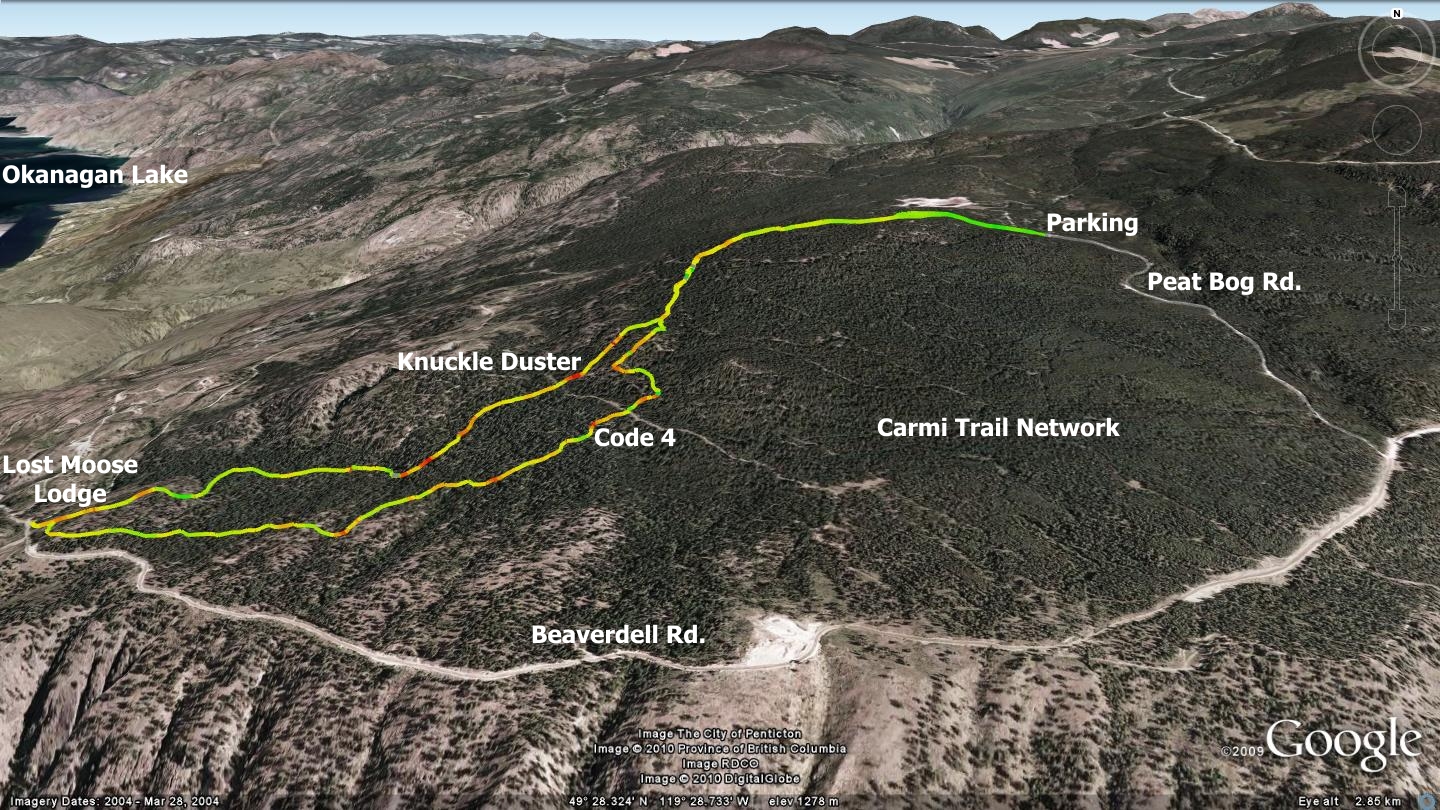
Both trails originate from the same point, split as they cross the top of the Carmi Recreational Trail System, and then merge at the bottom, near the Lost Moose Lodge. Peat Bog riding trails are definitely double-black diamond material. Do not venture onto these trails unless you are an extremely confident rider and possess proper downhill riding attire. If this sounds like you, and time allows - try out both trails.
The bottom parking area, known as the Garnet Fire Interpretive Site, is located directly across from the driveway to the Lost Moose Lodge. The top parking area is located 2.1 kilometers along the Peat Bog road, on the left hand side. Peat Bog Rd. appears as a left turn, 4.5 kilometers beyond the Garnet Fire Interpretive Site. The combined Code 4 / Knuckleduster trailhead is accessed by the following means:
- Park at the Garnet Fire Interpretive Site, then ride your bike up the gravel road to the Peat Bog Rd. turnoff. Follow this road to the left hand trailhead. Two large concrete blocks on your left mark the entrance to the Peat Bog road. This option allows you to start and a finish at your vehicle
- Use two vehicles and shuttle to the top parking area. You avoid the initial road climb, but require a second shuttle vehicle, which is not always possible or convenient
No matter which option you choose, use extreme caution while travelling the Peat Bog Rd. It is a commercial transportation route, and as such, is frequented by trucks and other heavy equipment hauling peat moss between the harvesting site and Penticton. Traffic may be on-route seven days a week, at all hours of the day. Each trail is fairly short, but with a little planning and a lot of sweat, taken together, they make for a great day.
The area is laden with wooden stunts; at the time of writing, most of them are of questionable stability. If intending to ride any of these stunts, it is critical that you thoroughly check out each one prior to ‘launch’.
Getting there Beginning at the Peach in Penticton, drive up Winnipeg St. to Eckhardt Ave. Turn left on Eckhardt and drive to Government St. Turn right on Government St. and continue to Carmi Ave. Take a left onto Carmi and stay on it to the intersection with Beaverdell Rd., turn right on Beaverdell. Stay on Beaverdell to the cattle guard / Garnet Fire Interpretive Site parking lot.
Low: 1030m | High: 1475m | Length: ±5km per trail | Water: Not potable | Cell Access: Spotty