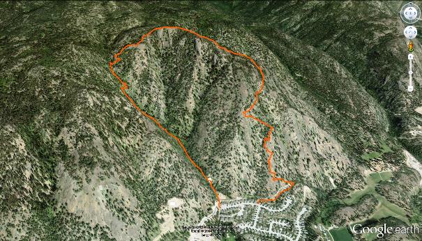
Carrot Mountain hosts several excellent trails, including the multi-use Smith Creek trail network on the south face of the height of land, and this hiking-specific route, the Davidson Cr. trail on its east slope. I’ve been meaning to get around to experiencing this adventure for several years, but it wasn’t until the HikingAddiction.ca group invited me to join them in April of 2014 that I finally explored the area.
This difficult and often strenuous hike takes you on a steady, steep incline to a spectacular view over West Kelowna, Shannon Lake and Okanagan Lake. Depending on the time of year that you enjoy the trail, you may face either a partially water-covered ascent as the spring freshet engorges the small creek, a dry trail mid-to-late summer or an icy adventure during the winter. Based on the overall slope of the route, I’d suggest that you skip the winter option. Early spring, just before Davidson Creek becomes too strong, might be best, as it’s crossable at all required points and the waterfalls - dried up much of the summer and fall - are beautiful.
The Davidson Cr. trail will take all of your quadriceps power - front and back, so wear sturdy footwear, bring hiking poles and take your time enroute. Bear, elk and deer compliment Fireweed and Indian Paintbrush along with Saskatoon berries, Ponderosa pine, arnica, clematis, wild strawberry, balsamroot, penstemon and prickly pear cactus.
I’d suggest that you enjoy the route in a clockwise direction. Its trailhead begins at the end of Shannon Height’s Place, or alternately, the end of Paramount Drive, depending on the streets that you used to reach this position - only a gate separates the two roads. The start position presents a steep two-track service road heading up the mountainside.
The route rises approximately 581 meters, and you will find yourself aggressively gaining elevation from the very outset. Two hundred meters up a service road you’ll pass an in-ground water storage tank, from there you are on singletrack all the way to the top and back down the opposite slope. The trail hugs the creek for much of the steep ascent, providing scant hope of keeping your feet dry in the spring.
There are numerous look-offs along the well-flagged trail, with the most spectacular being the summit, 2.4km along. Though this sounds like a short jaunt, it’ll likely be one of the most arduous 2.4kmkm of you hiking careers :-) The descent, located on an opposing ridgeline to the northwest, is equally as challenging, with many steep and loose sections. Hiking poles at hand, patience as your guide, this should however, be doable for anyone in decent physical condition. I’d suggest skipping the canine companionship on this hike due to cliffs and cactus.
You will pop out onto Shannon Heights Place via a paved path between homes, and find your vehicles located a short distance uphill to your right.
From the intersection of Hwy.97 and Bartley Rd., head north on Bartley, left on Shannon Lk. Rd., right on Mountain Hollow Lane, right on Paramount Dr., follow it all the way to it’s terminus.
Vertical: 591m | Length: 5.3km | Water: Not Potable | Cell: Full
