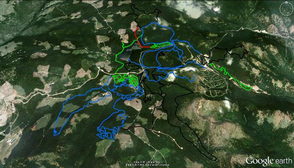
Apex Ski Resort and surrounding area are a popular location for cross-country and back-country ('off-track') skiing, as well as snowshoeing. The area sees some of the deepest, road-accessible snowfall zones in the Okanagan, and has been 'trailed' by various groups since way before there was a downhill ski resort on the height of land known as Beaconsfield Mountain. Click the map above to enlarge it.
Which brings up an interesting point; Apex Ski Resort, the popular downhill ski resort, is actually built upon Beaconsfield Mt. The actual Apex Mountain is referred to as "Apex Proper", and lies immediately south of Beaconsfield Mt., separated by a dip in the land known as "The Saddle".
Those who know the area well, will have noticed that I left off quite a few back-country winter trails. This was done on purpose, as I am not keen to see folks wandering into avalanche areas...
Which is not to say that avalanches can't happen on shallow slopes, and even in forested areas! Please read through the Canadian Avalanche Association website to learn the things that you need to know before you go off plunking around in the hills during the winter.
The Apex Winter Trails described here include the pay-to-use, track-set Nickel Plate Lake XC-trails, as well as a wide variety of free 'off-trail' networks. There exists a considerable amount of angst between off-trail skiers and snow-shoe enthusiasts in that snowshoers have a tendency to snowshoe upon the tracks laid down by back-country skiers.
The simplest way around this is for snowshoe enthusiasts to avoid trodding upon the trails of the skiers. This sounds easy and logical, but more often than not, the temptation to use the 'route-easier-followed' finds snowshoers in trouble with the skiers. I've heard some pretty loud arguments in the forest over this issue - which ruins everyone's beautiful day...
Do it right; make your own tracks and stick to them.
Please note the red-colored Google Earth track titled 'Burn to Lake' ("Active Log 126" in the .GPX file list). The GPS data for this track is not currently GPS-accurate. Please avoid this route for the short-term, I'll be back up Apex in the near future to record it and will update this site at that point.
Also note that, aside from the Nickel Plate Lake xc-ski trails, most of the other area trails are not well-marked (if at all). While the Apex Property Owners Association has gone to great lengths to mark some of the back-country ski trails, the rest are, well, "an unmarked free-for-all". As such, please download and use the Google Earth and / or GPS tracks from SweetSingletrack.ca in order to navigate with confidence.
Beaconsfield Mt. hosts a variety of cellular radio repeater towers, and thus, cell phone coverage in the area is pretty decent.
